Geography: Meaning, Scope, Importance and Basic Geographical Thinking
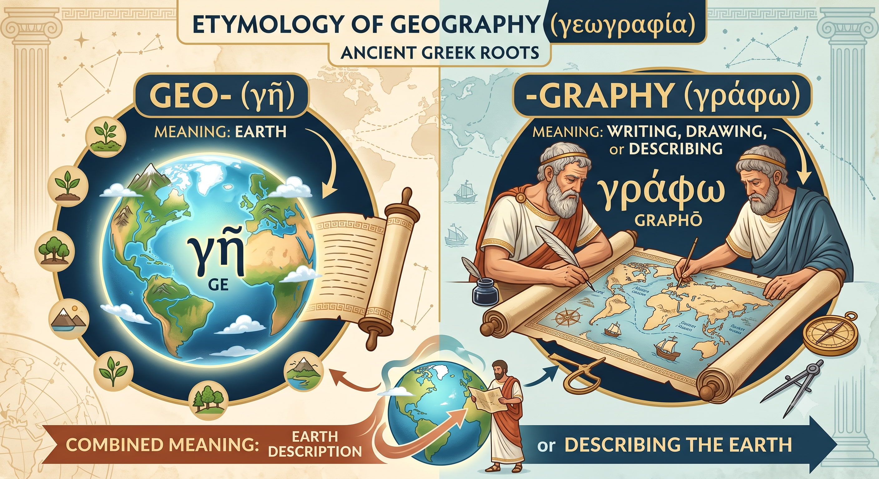
Geography is the story of Earth, nature and humans. It explains where things are, why they are there, how they are connected, and how they affect human life.
For UPSC, Geography is not a subject of isolated facts. It is a connecting subject that links the Universe, Earth systems, climate, resources, society, economy, environment, disasters and geopolitics.
1. What is Geography?
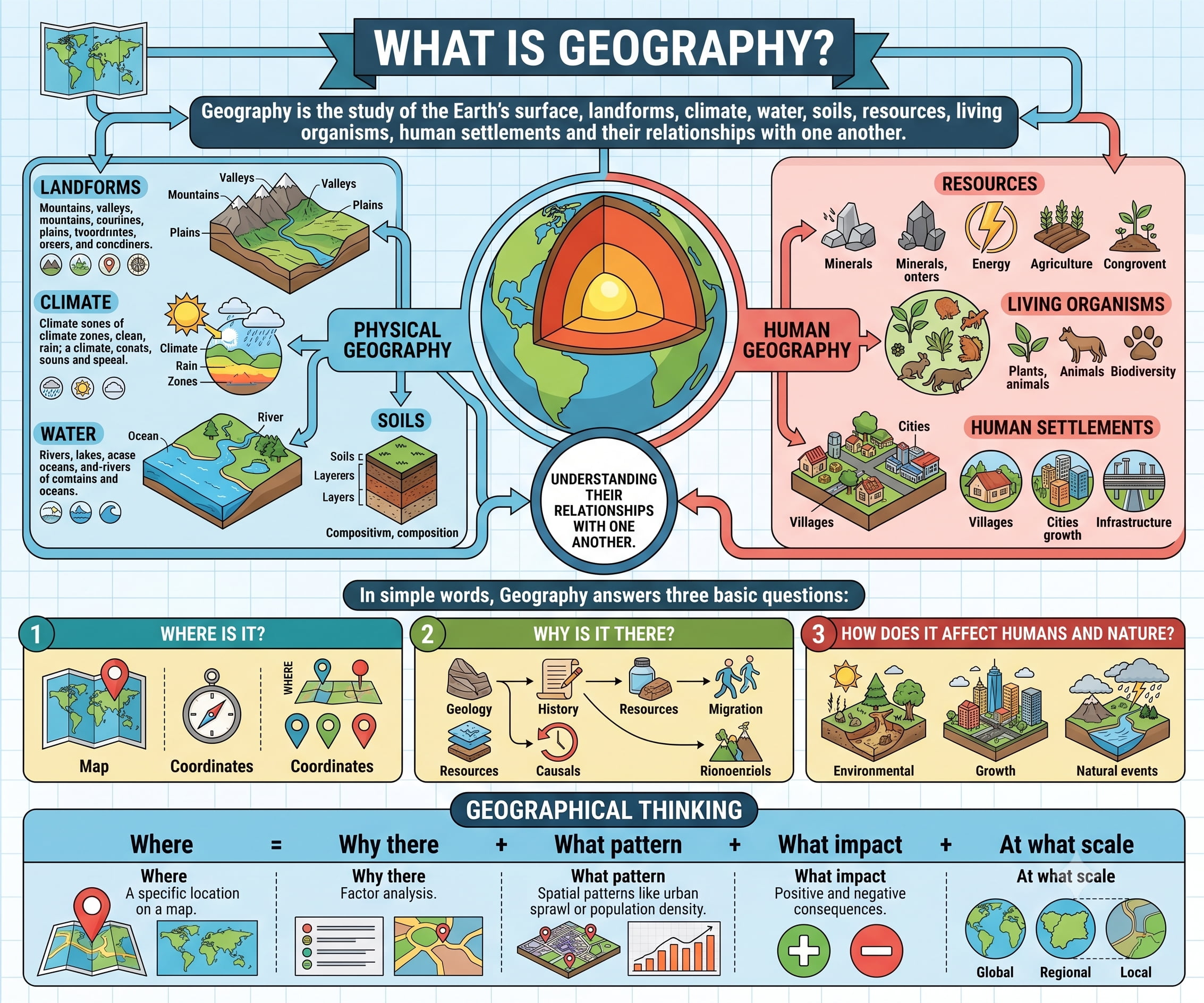
Geography is the study of the Earth’s surface, landforms, climate, water, soils, resources, living organisms, human settlements and their relationships with one another.
In simple words, Geography answers three basic questions: Where is it? Why is it there? and How does it affect humans and nature?
2. Geography is a Connecting Subject
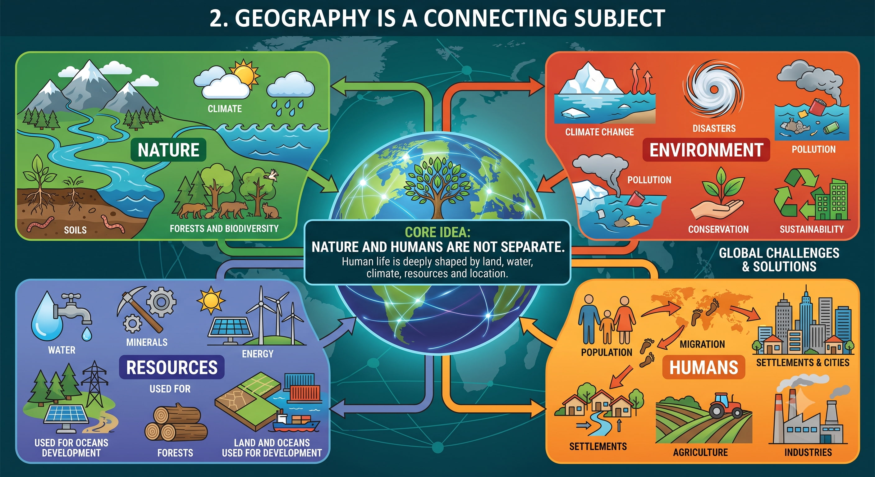
Nature
Mountains, rivers, oceans, climate, soils, forests and biodiversity.
Humans
Population, migration, settlements, agriculture, industries and cities.
Resources
Water, minerals, energy, forests, land and oceans used for development.
Environment
Climate change, disasters, pollution, conservation and sustainability.
Core Idea: Geography teaches that nature and humans are not separate. Human life is deeply shaped by land, water, climate, resources and location.
3. The Big Chain: Universe to Civilization
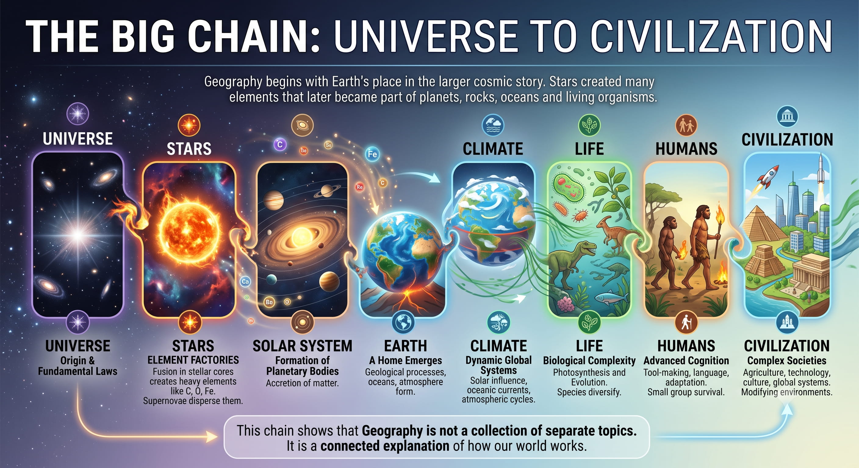
Geography begins with Earth’s place in the larger cosmic story. Stars created many elements that later became part of planets, rocks, oceans and living organisms.
This chain shows that Geography is not a collection of separate topics. It is a connected explanation of how our world works.
4. Earth as a System
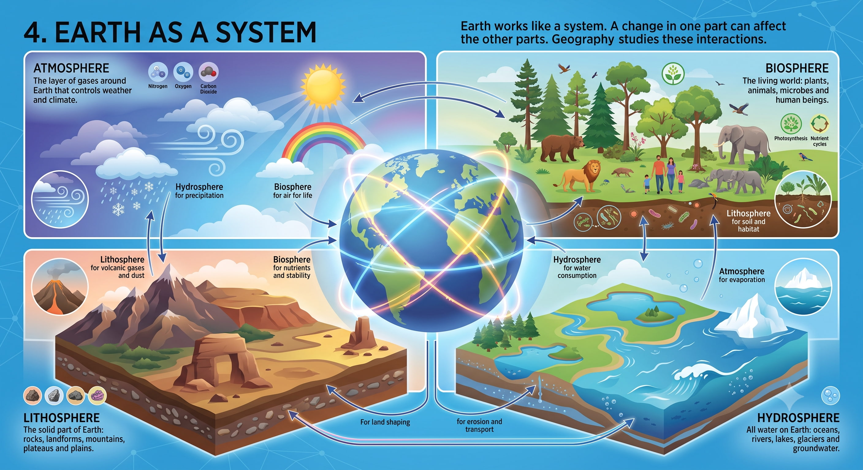
Earth works like a system. A change in one part can affect the other parts. Geography studies these interactions.
Lithosphere
The solid part of Earth: rocks, landforms, mountains, plateaus and plains.
Atmosphere
The layer of gases around Earth that controls weather and climate.
Hydrosphere
All water on Earth: oceans, rivers, lakes, glaciers and groundwater.
Biosphere
The living world: plants, animals, microbes and human beings.
5. Geography as a Bridge between Nature and Society
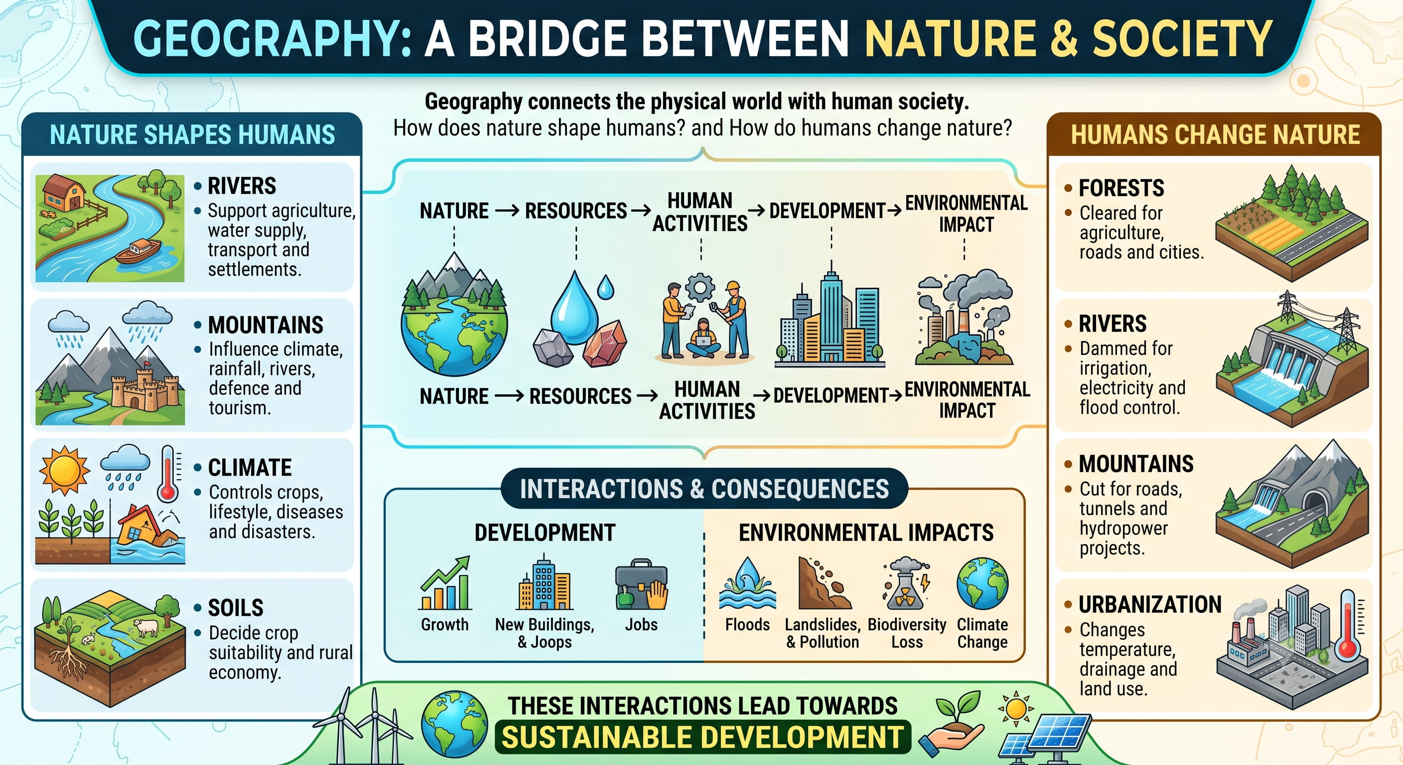
Geography connects the physical world with human society. It asks both: How does nature shape humans? and How do humans change nature?
Nature Shapes Humans
Rivers support agriculture, water supply, transport and settlements.
Mountains influence climate, rainfall, rivers, defence and tourism.
Climate controls crops, lifestyle, diseases and disasters.
Soils decide crop suitability and rural economy.
Humans Change Nature
Forests are cleared for agriculture, roads and cities.
Rivers are dammed for irrigation, electricity and flood control.
Mountains are cut for roads, tunnels and hydropower projects.
Urbanization changes temperature, drainage and land use.
These interactions create development, but they may also create floods, landslides, pollution, biodiversity loss and climate change. Therefore, Geography naturally leads us towards sustainable development.
6. Three Major Dimensions of Geography
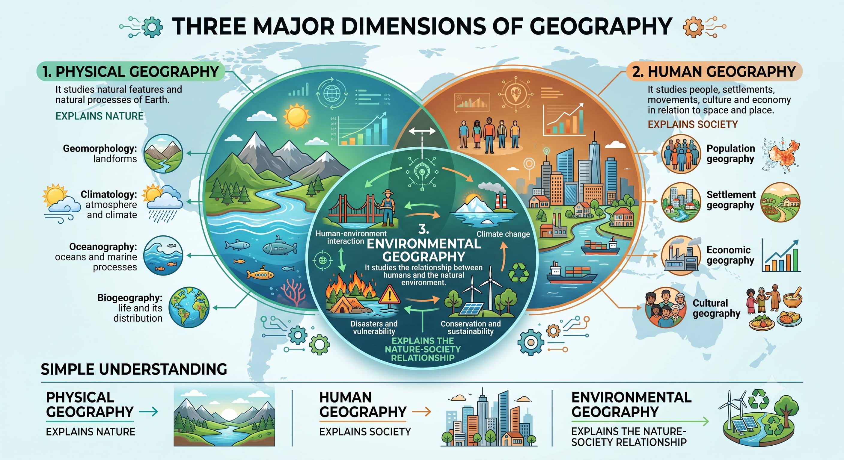
Physical Geography
It studies natural features and natural processes of Earth.
Geomorphology: landforms
Climatology: atmosphere and climate
Oceanography: oceans and marine processes
Biogeography: life and its distribution
Human Geography
It studies people, settlements, movements, culture and economy in relation to space and place.
Population geography
Settlement geography
Economic geography
Cultural geography
Environmental Geography
It studies the relationship between humans and the natural environment.
Human-environment interaction
Climate change
Disasters and vulnerability
Conservation and sustainability
Simple Understanding: Physical Geography explains nature, Human Geography explains society, and Environmental Geography explains the nature-society relationship.
7. Basic Geographical Thinking: Five Core Ideas
A normal learner may ask only “where is this place?” A Geography student asks: where, why there, what pattern, what impact and at what scale.
Space
The arrangement or distribution of things on Earth. Example: population is dense in the Ganga Plain due to fertile soil, water and flat land.
Place
A specific part of Earth with its own identity. Example: Varanasi is shaped by the Ganga, spirituality, culture and ancient urban history.
Region
An area with common features. Example: Himalayan Region, Thar Desert, Deccan Plateau, industrial belt or planning region.
Location
Where something is found. It may be absolute using latitude-longitude or relative in relation to other places.
Scale
The level of study: local, regional, national or global. The same issue can look different at different scales.
8. One Example: Heatwave Through Geographical Thinking
Location
Where is the heatwave occurring?
Space and Pattern
Is it limited to a city, a plain, a state or a wider region?
Place
How do urban concrete, land use and local conditions intensify heat?
Scale
How is it linked to local planning, regional climate and global warming?
9. Why Geography Matters for UPSC
Geography is useful in Prelims, Mains, Essay and Interview because it connects static concepts with current affairs and real-world problems.
Prelims
Maps, rivers, mountains, straits, seas, climate, soils, agriculture, minerals, biodiversity and places in news.
Mains GS Paper I
Physical geography, world geography, Indian geography, population, migration and urbanization.
Mains GS Paper III
Agriculture, resources, disasters, environment, conservation and climate change.
Essay and Interview
Development, sustainability, water crisis, cities, disasters, geopolitics and local area questions.
10. Geography Connects Static and Current Affairs
Red Sea Crisis
To understand it, we must know the Red Sea, Suez Canal, Bab-el-Mandeb and global trade routes.
Assam Floods
To understand them, we need Brahmaputra, Himalayas, rainfall, sediment load and floodplains.
Heatwaves
To understand them, we need temperature, pressure, urbanization, land use and climate change.
11. How to Study Geography Smartly
Geography becomes easy when we stop memorizing long paragraphs and start studying it visually and logically.
Use maps: Locate rivers, mountains, countries, ports, straits, currents and national parks immediately.
Use diagrams: Draw simple diagrams for monsoon, plate boundaries, cyclones, tides, river landforms and ocean currents.
Use examples: Connect every concept with Indian and world examples.
Use current affairs: Attach places in news with atlas, physical features and strategic importance.
12. Quick Revision
Geography studies Earth, nature, humans and their relationships.
Its core questions are: where, why there, what pattern, what impact and at what scale.
Geography connects the Universe, Earth systems, climate, life and civilization.
Earth has four major interacting systems: lithosphere, atmosphere, hydrosphere and biosphere.
Physical Geography studies nature; Human Geography studies society; Environmental Geography studies nature-society interaction.
Space, place, region, location and scale are the five basic ideas of geographical thinking.
For UPSC, Geography connects static concepts, maps, current affairs, environment, economy, disasters and geopolitics.
Best study method: map + diagram + example + impact + UPSC linkage.
13. Think Like UPSC
UPSC does not ask Geography only as factual knowledge. It often tests whether you can connect location, process, impact and solution.
Prelims Lens
Locate places, compare features, identify patterns, and connect static geography with current affairs.
Mains Lens
Explain causes, impacts, regional variation, examples, diagrams and sustainable solutions.
Interview Lens
Connect your district, state, local rivers, crops, industries, disasters and development issues with geography.
UPSC Mantra: Do not read Geography as “facts to remember”; read it as “relationships to understand”.
भूगोल: अर्थ, क्षेत्र, महत्त्व और आधारभूत भौगोलिक सोच
भूगोल पृथ्वी, प्रकृति और मानव की कहानी है। यह बताता है कि चीजें कहाँ हैं, वे वहाँ क्यों हैं, वे आपस में कैसे जुड़ी हुई हैं, और वे मानव जीवन को कैसे प्रभावित करती हैं।
UPSC के लिए भूगोल अलग-अलग तथ्यों का विषय नहीं है। यह एक जोड़ने वाला विषय है, जो ब्रह्मांड, पृथ्वी तंत्र, जलवायु, संसाधन, समाज, अर्थव्यवस्था, पर्यावरण, आपदाओं और भू-राजनीति को आपस में जोड़ता है।
1. भूगोल क्या है?
भूगोल पृथ्वी की सतह, स्थलरूपों, जलवायु, जल, मिट्टियों, संसाधनों, जीव-जंतुओं, मानव बस्तियों और इनके आपसी संबंधों का अध्ययन है।
सरल शब्दों में, भूगोल तीन मूल प्रश्नों का उत्तर देता है: यह कहाँ है? यह वहाँ क्यों है? और यह मानव तथा प्रकृति को कैसे प्रभावित करता है?
2. भूगोल एक जोड़ने वाला विषय है
प्रकृति
पर्वत, नदियाँ, महासागर, जलवायु, मिट्टियाँ, वन और जैव विविधता।
मानव
जनसंख्या, प्रवास, बस्तियाँ, कृषि, उद्योग और नगर।
संसाधन
जल, खनिज, ऊर्जा, वन, भूमि और महासागर, जिनका उपयोग विकास के लिए किया जाता है।
पर्यावरण
जलवायु परिवर्तन, आपदाएँ, प्रदूषण, संरक्षण और सततता।
मुख्य विचार: भूगोल यह सिखाता है कि प्रकृति और मानव अलग-अलग नहीं हैं। मानव जीवन भूमि, जल, जलवायु, संसाधनों और स्थान से गहराई से प्रभावित होता है।
3. बड़ी श्रृंखला: ब्रह्मांड से सभ्यता तक
भूगोल पृथ्वी की स्थिति को व्यापक ब्रह्मांडीय कहानी से जोड़कर समझना शुरू करता है। तारों ने अनेक तत्वों का निर्माण किया, जो बाद में ग्रहों, चट्टानों, महासागरों और जीवित प्राणियों का हिस्सा बने।
यह श्रृंखला दिखाती है कि भूगोल अलग-अलग विषयों का संग्रह नहीं है। यह इस बात की जुड़ी हुई व्याख्या है कि हमारा विश्व कैसे काम करता है।
4. पृथ्वी एक तंत्र के रूप में
पृथ्वी एक तंत्र की तरह काम करती है। इसके एक भाग में होने वाला परिवर्तन दूसरे भागों को प्रभावित कर सकता है। भूगोल इन्हीं अंतःक्रियाओं का अध्ययन करता है।
स्थलमंडल
पृथ्वी का ठोस भाग: चट्टानें, स्थलरूप, पर्वत, पठार और मैदान।
वायुमंडल
पृथ्वी के चारों ओर गैसों की परत, जो मौसम और जलवायु को नियंत्रित करती है।
जलमंडल
पृथ्वी का समस्त जल: महासागर, नदियाँ, झीलें, हिमनद और भूजल।
जीवमंडल
जीवित संसार: पौधे, पशु, सूक्ष्मजीव और मानव।
5. भूगोल: प्रकृति और समाज के बीच सेतु
भूगोल भौतिक संसार को मानव समाज से जोड़ता है। यह दोनों प्रश्न पूछता है: प्रकृति मानव को कैसे आकार देती है? और मानव प्रकृति को कैसे बदलता है?
प्रकृति मानव को आकार देती है
नदियाँ कृषि, जल आपूर्ति, परिवहन और बस्तियों को सहारा देती हैं।
पर्वत जलवायु, वर्षा, नदियों, रक्षा और पर्यटन को प्रभावित करते हैं।
जलवायु फसलों, जीवन-शैली, रोगों और आपदाओं को नियंत्रित करती है।
मिट्टियाँ फसल की उपयुक्तता और ग्रामीण अर्थव्यवस्था को निर्धारित करती हैं।
मानव प्रकृति को बदलता है
कृषि, सड़कों और शहरों के लिए वनों की कटाई की जाती है।
सिंचाई, बिजली और बाढ़ नियंत्रण के लिए नदियों पर बाँध बनाए जाते हैं।
सड़कों, सुरंगों और जलविद्युत परियोजनाओं के लिए पर्वतों को काटा जाता है।
नगरीकरण तापमान, जल निकासी और भूमि उपयोग को बदल देता है।
ये अंतःक्रियाएँ विकास लाती हैं, लेकिन इनके कारण बाढ़, भूस्खलन, प्रदूषण, जैव विविधता की हानि और जलवायु परिवर्तन जैसी समस्याएँ भी पैदा हो सकती हैं। इसलिए भूगोल स्वाभाविक रूप से हमें सतत विकास की ओर ले जाता है।
6. भूगोल के तीन प्रमुख आयाम
भौतिक भूगोल
यह पृथ्वी की प्राकृतिक विशेषताओं और प्राकृतिक प्रक्रियाओं का अध्ययन करता है।
भू-आकृति विज्ञान: स्थलरूप
जलवायु विज्ञान: वायुमंडल और जलवायु
समुद्र विज्ञान: महासागर और समुद्री प्रक्रियाएँ
जैव भूगोल: जीवन और उसका वितरण
मानव भूगोल
यह लोगों, बस्तियों, आवागमन, संस्कृति और अर्थव्यवस्था का स्थान और क्षेत्र के संदर्भ में अध्ययन करता है।
जनसंख्या भूगोल
बस्ती भूगोल
आर्थिक भूगोल
सांस्कृतिक भूगोल
पर्यावरणीय भूगोल
यह मानव और प्राकृतिक पर्यावरण के संबंधों का अध्ययन करता है।
मानव-पर्यावरण अंतःक्रिया
जलवायु परिवर्तन
आपदाएँ और संवेदनशीलता
संरक्षण और सततता
सरल समझ: भौतिक भूगोल प्रकृति को समझाता है, मानव भूगोल समाज को समझाता है, और पर्यावरणीय भूगोल प्रकृति-समाज संबंध को समझाता है।
7. आधारभूत भौगोलिक सोच: पाँच मुख्य विचार
एक सामान्य विद्यार्थी केवल यह पूछ सकता है कि “यह स्थान कहाँ है?” लेकिन भूगोल का विद्यार्थी पूछता है: कहाँ, वहाँ क्यों, क्या पैटर्न है, क्या प्रभाव है और किस स्तर पर है।
स्थानिक विस्तार
पृथ्वी पर चीजों की व्यवस्था या वितरण। उदाहरण: गंगा के मैदान में उपजाऊ मिट्टी, जल और समतल भूमि के कारण जनसंख्या घनी है।
स्थान
पृथ्वी का कोई विशिष्ट भाग, जिसकी अपनी पहचान होती है। उदाहरण: वाराणसी गंगा, आध्यात्मिकता, संस्कृति और प्राचीन नगरीय इतिहास से निर्मित है।
प्रदेश
समान विशेषताओं वाला क्षेत्र। उदाहरण: हिमालयी क्षेत्र, थार मरुस्थल, दक्कन का पठार, औद्योगिक पट्टी या नियोजन क्षेत्र।
स्थिति
कोई चीज कहाँ पाई जाती है। यह अक्षांश-देशांतर के आधार पर निरपेक्ष हो सकती है या अन्य स्थानों के संबंध में सापेक्ष हो सकती है।
स्तर
अध्ययन का स्तर: स्थानीय, क्षेत्रीय, राष्ट्रीय या वैश्विक। एक ही मुद्दा अलग-अलग स्तरों पर अलग दिखाई दे सकता है।
8. एक उदाहरण: लू को भौगोलिक सोच से समझना
स्थिति
लू कहाँ चल रही है?
स्थानिक विस्तार और पैटर्न
क्या यह केवल किसी शहर तक सीमित है, किसी मैदान तक, किसी राज्य तक या बड़े क्षेत्र तक फैली है?
स्थान
शहरी कंक्रीट, भूमि उपयोग और स्थानीय परिस्थितियाँ गर्मी को कैसे बढ़ाती हैं?
स्तर
यह स्थानीय नियोजन, क्षेत्रीय जलवायु और वैश्विक तापन से कैसे जुड़ी है?
9. UPSC के लिए भूगोल क्यों महत्त्वपूर्ण है?
भूगोल प्रारंभिक परीक्षा, मुख्य परीक्षा, निबंध और साक्षात्कार में उपयोगी है, क्योंकि यह स्थिर अवधारणाओं को समसामयिक घटनाओं और वास्तविक दुनिया की समस्याओं से जोड़ता है।
प्रारंभिक परीक्षा
मानचित्र, नदियाँ, पर्वत, जलडमरूमध्य, समुद्र, जलवायु, मिट्टियाँ, कृषि, खनिज, जैव विविधता और समाचारों में रहे स्थान।
मुख्य परीक्षा GS पेपर I
भौतिक भूगोल, विश्व भूगोल, भारत का भूगोल, जनसंख्या, प्रवास और नगरीकरण।
मुख्य परीक्षा GS पेपर III
कृषि, संसाधन, आपदाएँ, पर्यावरण, संरक्षण और जलवायु परिवर्तन।
निबंध और साक्षात्कार
विकास, सततता, जल संकट, नगर, आपदाएँ, भू-राजनीति और स्थानीय क्षेत्र से जुड़े प्रश्न।
10. भूगोल स्थिर विषय और समसामयिक घटनाओं को जोड़ता है
लाल सागर संकट
इसे समझने के लिए लाल सागर, स्वेज नहर, बाब-अल-मंदेब और वैश्विक व्यापार मार्गों को जानना आवश्यक है।
असम की बाढ़
इसे समझने के लिए ब्रह्मपुत्र, हिमालय, वर्षा, अवसाद भार और बाढ़ मैदानों को समझना आवश्यक है।
लू
इसे समझने के लिए तापमान, वायुदाब, नगरीकरण, भूमि उपयोग और जलवायु परिवर्तन को समझना आवश्यक है।
11. भूगोल को समझदारी से कैसे पढ़ें?
भूगोल तब आसान हो जाता है, जब हम लंबे पैराग्राफ याद करना छोड़कर उसे दृश्यात्मक और तार्किक ढंग से पढ़ना शुरू करते हैं।
मानचित्रों का उपयोग करें: नदियों, पर्वतों, देशों, बंदरगाहों, जलडमरूमध्यों, धाराओं और राष्ट्रीय उद्यानों को तुरंत atlas/map में देखें।
आरेखों का उपयोग करें: मानसून, प्लेट सीमाएँ, चक्रवात, ज्वार-भाटा, नदी स्थलरूप और महासागरीय धाराओं के सरल आरेख बनाएं।
उदाहरणों का उपयोग करें: हर अवधारणा को भारत और विश्व के उदाहरणों से जोड़ें।
समसामयिक घटनाओं का उपयोग करें: समाचारों में रहे स्थानों को atlas, भौतिक विशेषताओं और सामरिक महत्त्व से जोड़ें।
12. त्वरित पुनरावृत्ति
भूगोल पृथ्वी, प्रकृति, मानव और उनके संबंधों का अध्ययन करता है।
इसके मुख्य प्रश्न हैं: कहाँ, वहाँ क्यों, क्या पैटर्न, क्या प्रभाव और किस स्तर पर।
भूगोल ब्रह्मांड, पृथ्वी तंत्र, जलवायु, जीवन और सभ्यता को जोड़ता है।
पृथ्वी के चार प्रमुख अंतःक्रियाशील तंत्र हैं: स्थलमंडल, वायुमंडल, जलमंडल और जीवमंडल।
भौतिक भूगोल प्रकृति का अध्ययन करता है; मानव भूगोल समाज का अध्ययन करता है; पर्यावरणीय भूगोल प्रकृति-समाज अंतःक्रिया का अध्ययन करता है।
स्थानिक विस्तार, स्थान, प्रदेश, स्थिति और स्तर भौगोलिक सोच के पाँच आधारभूत विचार हैं।
UPSC के लिए भूगोल स्थिर अवधारणाओं, मानचित्रों, समसामयिक घटनाओं, पर्यावरण, अर्थव्यवस्था, आपदाओं और भू-राजनीति को जोड़ता है।
सबसे अच्छा अध्ययन तरीका: मानचित्र + आरेख + उदाहरण + प्रभाव + UPSC लिंक।
13. UPSC की तरह सोचें
UPSC भूगोल को केवल तथ्यात्मक ज्ञान के रूप में नहीं पूछता। वह अक्सर यह परखता है कि आप स्थिति, प्रक्रिया, प्रभाव और समाधान को जोड़ सकते हैं या नहीं।
प्रारंभिक परीक्षा दृष्टिकोण
स्थानों को पहचानना, विशेषताओं की तुलना करना, पैटर्न को समझना और स्थिर भूगोल को समसामयिक घटनाओं से जोड़ना।
मुख्य परीक्षा दृष्टिकोण
कारण, प्रभाव, क्षेत्रीय विविधता, उदाहरण, आरेख और सतत समाधान समझाना।
साक्षात्कार दृष्टिकोण
अपने जिले, राज्य, स्थानीय नदियों, फसलों, उद्योगों, आपदाओं और विकास से जुड़े मुद्दों को भूगोल से जोड़ना।
UPSC मंत्र: भूगोल को “याद रखने वाले तथ्यों” के रूप में न पढ़ें; इसे “समझने योग्य संबंधों” के रूप में पढ़ें।