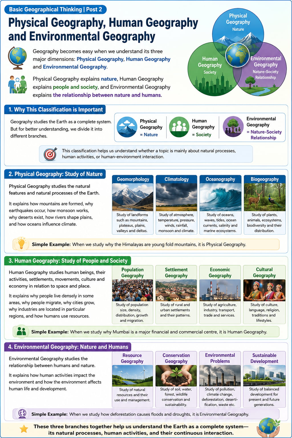
Physical Geography, Human Geography and Environmental Geography
Geography becomes easy when we understand its three major dimensions: Physical Geography, Human Geography and Environmental Geography.
Physical Geography explains nature, Human Geography explains people and society, and Environmental Geography explains the relationship between nature and humans.
📌 View Visual Roadmap: Three Major Dimensions of Geography
This visual summary explains how Physical Geography studies nature, Human Geography studies society, and Environmental Geography studies the relationship between nature and humans.
1. Why This Classification is Important
Geography studies the Earth as a complete system. But for better understanding, we divide it into different branches.
This classification helps us understand whether a topic is mainly about natural processes, human activities, or human-environment interaction.
2. Physical Geography: Study of Nature
Physical Geography studies the natural features and natural processes of the Earth.
It explains how mountains are formed, why earthquakes occur, how monsoon works, why deserts exist, how rivers shape plains, and how oceans influence climate.
Geomorphology
Study of landforms such as mountains, plateaus, plains, valleys and deltas.
Climatology
Study of atmosphere, temperature, pressure, winds, rainfall, monsoon and climate.
Oceanography
Study of oceans, waves, tides, ocean currents, salinity and marine ecosystems.
Biogeography
Study of plants, animals, ecosystems, biodiversity and their distribution.
Simple Example: When we study why the Himalayas are young fold mountains, it is Physical Geography.
3. Human Geography: Study of People and Society
Human Geography studies human beings, their activities, settlements, movements, culture and economy in relation to space and place.
It explains why people live densely in some areas, why people migrate, why cities grow, why industries are located in particular regions, and how humans use resources.
Population Geography
Study of population distribution, density, growth, age structure and migration.
Settlement Geography
Study of villages, towns, cities, urbanization and settlement patterns.
Economic Geography
Study of agriculture, industries, trade, transport, resources and development.
Cultural Geography
Study of language, religion, tribes, culture, traditions and regional identity.
Simple Example: When we study why people migrate from villages to cities, it is Human Geography.
4. Environmental Geography: Study of Human-Nature Interaction
Environmental Geography studies the relationship between humans and the natural environment.
It asks two major questions: How does nature influence human life? And how do human activities change nature?
Climate Change
Human activities increase greenhouse gases, leading to global warming and extreme events.
Deforestation
Forest loss affects biodiversity, rainfall, soil, rivers and tribal communities.
Disasters
Floods, landslides and cyclones become more harmful when vulnerability increases.
Sustainability
Balanced development protects resources for present and future generations.
Simple Example: When we study how urbanization increases flood risk, it is Environmental Geography.
5. How These Three Branches Work Together
In real life, Physical, Human and Environmental Geography are deeply connected. One topic often belongs to all three branches.
Example: River
Physical: Origin, course, basin, floodplain.
Human: Agriculture, settlements, transport.
Environmental: Pollution, floods, conservation.
Example: Monsoon
Physical: Wind, pressure, rainfall.
Human: Crops, water supply, economy.
Environmental: Droughts, floods, climate change.
Example: City
Physical: Site, drainage, climate.
Human: Population, transport, economy.
Environmental: Pollution, heat island, urban floods.
6. UPSC Relevance
UPSC questions often require combined understanding of all three branches.
- Prelims: Physical concepts, maps, environment, agriculture, resources and places in news.
- Mains GS Paper I: Physical geography, population, urbanization and world geography.
- Mains GS Paper III: Agriculture, resources, disasters, environment and climate change.
- Essay: Development, environment, sustainability, urbanization and climate crisis.
Quick Revision
- Physical Geography studies natural features and natural processes.
- Human Geography studies people, settlements, culture, economy and society.
- Environmental Geography studies human-nature interaction and sustainability.
- A single topic may involve all three branches of Geography.
- Rivers, monsoon, cities, agriculture and disasters are best understood through integrated geographical thinking.
- UPSC expects connected understanding, not isolated memorization.
Think Like UPSC: Whenever you study any geographical topic, ask three questions: What is the physical process? What is the human impact? What is the environmental consequence?
भौतिक भूगोल, मानव भूगोल और पर्यावरणीय भूगोल
भूगोल आसान हो जाता है जब हम उसके तीन प्रमुख आयामों को समझते हैं: भौतिक भूगोल, मानव भूगोल और पर्यावरणीय भूगोल।
भौतिक भूगोल प्रकृति को समझाता है, मानव भूगोल लोगों और समाज को समझाता है, और पर्यावरणीय भूगोल प्रकृति और मानव के संबंध को समझाता है।
📌 Visual Roadmap देखें: भूगोल के तीन प्रमुख आयाम
यह visual summary समझाती है कि भौतिक भूगोल प्रकृति का अध्ययन करता है, मानव भूगोल समाज का अध्ययन करता है, और पर्यावरणीय भूगोल प्रकृति और मानव के संबंधों का अध्ययन करता है।
1. यह वर्गीकरण क्यों महत्वपूर्ण है?
भूगोल पृथ्वी को एक पूर्ण प्रणाली के रूप में पढ़ता है। लेकिन बेहतर समझ के लिए हम इसे अलग-अलग शाखाओं में बाँटते हैं।
यह वर्गीकरण हमें समझने में मदद करता है कि कोई topic मुख्य रूप से प्राकृतिक प्रक्रियाओं, मानवीय गतिविधियों या मानव-पर्यावरण अंतःक्रिया से जुड़ा है।
2. भौतिक भूगोल: प्रकृति का अध्ययन
भौतिक भूगोल पृथ्वी की प्राकृतिक विशेषताओं और प्राकृतिक प्रक्रियाओं का अध्ययन करता है।
यह समझाता है कि पर्वत कैसे बनते हैं, भूकंप क्यों आते हैं, मानसून कैसे काम करता है, मरुस्थल क्यों पाए जाते हैं, नदियाँ मैदानों को कैसे आकार देती हैं और महासागर जलवायु को कैसे प्रभावित करते हैं।
भू-आकृति विज्ञान
पर्वत, पठार, मैदान, घाटियाँ और डेल्टा जैसे स्थलरूपों का अध्ययन।
जलवायु विज्ञान
वायुमंडल, तापमान, दाब, पवन, वर्षा, मानसून और जलवायु का अध्ययन।
समुद्र विज्ञान
महासागरों, तरंगों, ज्वार-भाटा, महासागरीय धाराओं, लवणता और समुद्री पारितंत्रों का अध्ययन।
जैव-भूगोल
पौधों, जानवरों, पारितंत्रों, जैव विविधता और उनके वितरण का अध्ययन।
सरल उदाहरण: जब हम पढ़ते हैं कि हिमालय युवा वलित पर्वत क्यों हैं, तो यह भौतिक भूगोल है।
3. मानव भूगोल: लोगों और समाज का अध्ययन
मानव भूगोल मानव beings, उनकी गतिविधियों, बसावटों, गतिशीलता, संस्कृति और अर्थव्यवस्था का अध्ययन space और place के संदर्भ में करता है।
यह समझाता है कि कुछ क्षेत्रों में लोग घनी संख्या में क्यों रहते हैं, लोग प्रवास क्यों करते हैं, शहर क्यों बढ़ते हैं, उद्योग विशेष क्षेत्रों में क्यों स्थित होते हैं और मानव संसाधनों का उपयोग कैसे करता है।
जनसंख्या भूगोल
जनसंख्या वितरण, घनत्व, वृद्धि, आयु संरचना और प्रवास का अध्ययन।
अधिवास भूगोल
गाँवों, कस्बों, शहरों, नगरीकरण और बसावट patterns का अध्ययन।
आर्थिक भूगोल
कृषि, उद्योग, व्यापार, परिवहन, संसाधन और विकास का अध्ययन।
सांस्कृतिक भूगोल
भाषा, धर्म, जनजातियों, संस्कृति, परंपराओं और क्षेत्रीय पहचान का अध्ययन।
सरल उदाहरण: जब हम पढ़ते हैं कि लोग गाँवों से शहरों की ओर प्रवास क्यों करते हैं, तो यह मानव भूगोल है।
4. पर्यावरणीय भूगोल: मानव-प्रकृति अंतःक्रिया का अध्ययन
पर्यावरणीय भूगोल मानव और प्राकृतिक पर्यावरण के बीच संबंधों का अध्ययन करता है।
यह दो प्रमुख प्रश्न पूछता है: प्रकृति मानव जीवन को कैसे प्रभावित करती है? और मानवीय गतिविधियाँ प्रकृति को कैसे बदलती हैं?
जलवायु परिवर्तन
मानवीय गतिविधियाँ greenhouse gases बढ़ाती हैं, जिससे global warming और extreme events बढ़ते हैं।
वनों की कटाई
वनों की हानि जैव विविधता, वर्षा, मिट्टी, नदियों और जनजातीय समुदायों को प्रभावित करती है।
आपदाएँ
जब vulnerability बढ़ती है, तो बाढ़, भूस्खलन और चक्रवात अधिक हानिकारक हो जाते हैं।
सततता
संतुलित विकास वर्तमान और भविष्य की पीढ़ियों के लिए संसाधनों की रक्षा करता है।
सरल उदाहरण: जब हम पढ़ते हैं कि नगरीकरण बाढ़ के खतरे को कैसे बढ़ाता है, तो यह पर्यावरणीय भूगोल है।
5. ये तीनों शाखाएँ मिलकर कैसे काम करती हैं?
वास्तविक जीवन में भौतिक, मानव और पर्यावरणीय भूगोल गहराई से जुड़े हुए हैं। एक topic अक्सर तीनों शाखाओं से संबंधित होता है।
उदाहरण: नदी
भौतिक: उद्गम, प्रवाह मार्ग, बेसिन, बाढ़ मैदान।
मानव: कृषि, बसावटें, परिवहन।
पर्यावरणीय: प्रदूषण, बाढ़, संरक्षण।
उदाहरण: मानसून
भौतिक: पवन, दाब, वर्षा।
मानव: फसलें, जल आपूर्ति, अर्थव्यवस्था।
पर्यावरणीय: सूखा, बाढ़, जलवायु परिवर्तन।
उदाहरण: शहर
भौतिक: स्थल, जल-निकास, जलवायु।
मानव: जनसंख्या, परिवहन, अर्थव्यवस्था।
पर्यावरणीय: प्रदूषण, heat island, urban floods।
6. UPSC में उपयोगिता
UPSC प्रश्नों में अक्सर तीनों शाखाओं की संयुक्त समझ की आवश्यकता होती है।
- Prelims: भौतिक अवधारणाएँ, maps, environment, agriculture, resources और places in news।
- Mains GS Paper I: भौतिक भूगोल, जनसंख्या, नगरीकरण और विश्व भूगोल।
- Mains GS Paper III: कृषि, संसाधन, आपदाएँ, पर्यावरण और जलवायु परिवर्तन।
- Essay: विकास, पर्यावरण, सततता, नगरीकरण और जलवायु संकट।
त्वरित पुनरावृत्ति
- भौतिक भूगोल प्राकृतिक विशेषताओं और प्राकृतिक प्रक्रियाओं का अध्ययन करता है।
- मानव भूगोल लोगों, बसावटों, संस्कृति, अर्थव्यवस्था और समाज का अध्ययन करता है।
- पर्यावरणीय भूगोल मानव-प्रकृति अंतःक्रिया और सततता का अध्ययन करता है।
- भूगोल का एक ही topic तीनों शाखाओं से जुड़ा हो सकता है।
- नदियाँ, मानसून, शहर, कृषि और आपदाएँ integrated geographical thinking से सबसे अच्छे तरीके से समझी जाती हैं।
- UPSC isolated memorization नहीं, बल्कि connected understanding चाहता है।
UPSC की तरह सोचें: जब भी आप कोई भौगोलिक topic पढ़ें, तीन प्रश्न पूछें: इसकी physical process क्या है? इसका human impact क्या है? इसका environmental consequence क्या है?