Earthquakes: Causes, Seismic Waves, Measurement, Distribution and Hazards
After understanding lithospheric plates and plate boundaries, earthquakes become easy to understand: tectonic movement creates stress, faults may remain locked, and sudden rupture releases stored energy as seismic waves.
1. Earthquake: Meaning and Basic Mechanism

An earthquake is the sudden shaking of the Earth produced by a sudden release of accumulated energy within the Earth.
Elastic Rebound Theory
Tectonic forces try to move rocks on opposite sides of a fault, but friction may keep them locked.
Stress gradually accumulates and the rocks deform.
When the accumulated stress becomes greater than friction and rock strength, the rocks suddenly slip and stored elastic energy is released.
2. Important Earthquake Terms
Fault
A fracture or break in rocks along which displacement occurs.
Focus / Hypocentre
Point inside Earth where earthquake rupture begins.
Epicentre
Point on Earth’s surface directly above the focus.
Foreshock
A smaller earthquake occurring before the main shock in the same region.
Aftershock
Smaller earthquakes following the main shock while the crust readjusts.
3. Types and Causes of Earthquakes
Tectonic Earthquake
Caused by sudden movement along faults due to tectonic stress. These are the most common earthquakes.
Volcanic Earthquake
Associated with movement of magma and volcanic activity.
Collapse Earthquake
Small earthquakes produced by collapse of underground mines, caves or cavities.
Explosion Earthquake
Tremors produced by large chemical or nuclear explosions.
Reservoir-Induced Earthquake
Filling of a large reservoir may alter stress and pore-water pressure and reactivate existing faults.
Indian example: Koyna region, Maharashtra.
Other Human-Induced Seismicity
Mining, fluid injection or extraction and some engineering activities may trigger seismic events.
4. Classification by Depth of Focus
Shallow-Focus
About 0–70 km.
Most earthquakes belong to this group and shallow earthquakes can be highly destructive.
Intermediate-Focus
About 70–300 km.
Deep-Focus
About 300–700 km.
Mainly associated with descending slabs at subduction zones.
5. Seismic Waves

Energy released at the focus travels outward in the form of seismic waves.
A. Body Waves
P Waves – Primary Waves
• Fastest seismic waves.
• Arrive first at seismic stations.
• Compressional or longitudinal.
• Particles vibrate parallel to wave direction.
• Produce compression and expansion.
• Travel through solids, liquids and gases.
S Waves – Secondary Waves
• Slower than P waves.
• Arrive after P waves.
• Shear or transverse waves.
• Particles vibrate perpendicular to wave direction.
• Travel only through solids.
• Cannot travel through liquids.
B. Surface Waves
Surface waves travel along or near Earth’s surface and are generally the most damaging earthquake waves.
Love Waves
Mainly produce horizontal side-to-side shearing motion.
Rayleigh Waves
Produce rolling motion involving both vertical and horizontal movement.
Generally Most Damaging: Surface Waves
6. Seismometer, Seismograph and Seismogram
Seismometer
Sensor used to detect ground motion.
Seismograph
System used to detect and record seismic waves.
Seismogram
Recorded trace of seismic-wave motion.
7. Reflection, Refraction and Wave Velocity
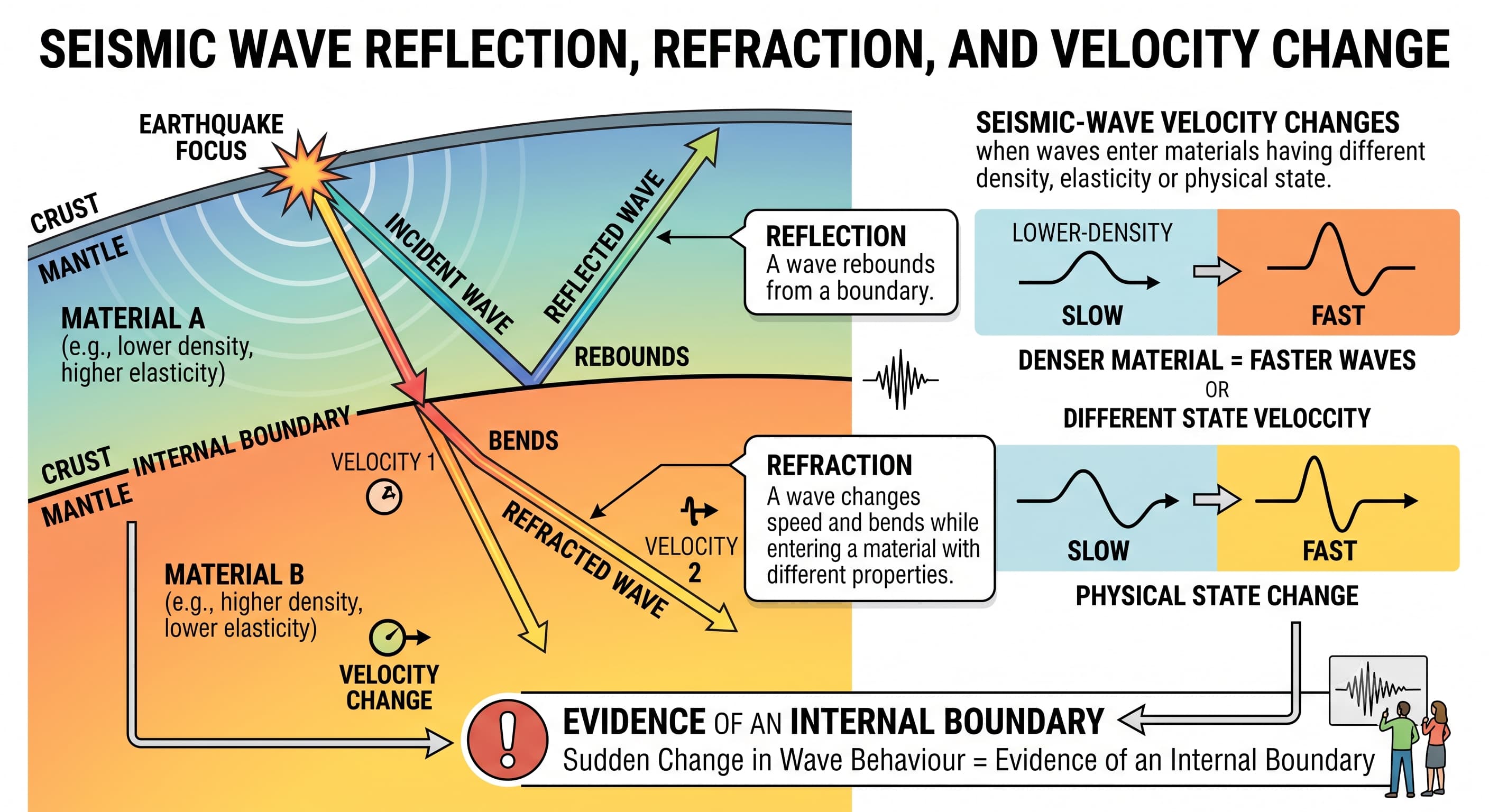
Seismic-wave velocity changes when waves enter material having different density, elasticity or physical state.
Reflection
A wave rebounds from a boundary.
Refraction
A wave changes speed and bends while entering material with different properties.
8. Seismic Shadow Zones
A shadow zone is a region where particular direct seismic waves from an earthquake are not recorded.
P-Wave Shadow Zone
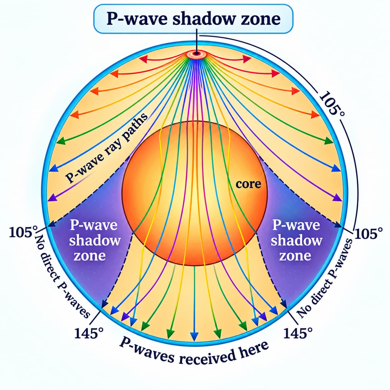
Direct P waves are not normally recorded approximately between 105° and 145°.
This results from strong refraction at the core-mantle boundary.
S-Wave Shadow Zone

Direct S waves are not recorded beyond approximately 105°.
This occurs because S waves cannot travel through the liquid outer core.
Link Back to Earth’s Interior
The behaviour of P and S waves is one of the strongest reasons we know that Earth is internally layered and that the outer core is liquid.
9. Measuring Earthquakes: Magnitude and Intensity
Intensity = Shaking and Damage at a Particular Place
A. Richter Magnitude Scale
The Richter Scale was developed by Charles F. Richter in 1935.
It was originally a local magnitude scale (ML) based mainly on recorded seismic-wave amplitude, corrected for distance.
Richter Scale is Logarithmic
↓
≈ 10× Greater Recorded Amplitude
↓
≈ 31–32× Greater Energy Release
Magnitude 5 → 7 = ≈ 100× Amplitude & ≈ 1,000× Energy
Does the Richter Scale End at 10?
No. Magnitude scales do not have a fixed 1–10 range. Very small earthquakes may even have negative magnitude values.
B. Moment Magnitude Scale (Mw)
Modern seismology generally uses the Moment Magnitude Scale (Mw), especially for significant and very large earthquakes.
It is based on seismic moment, which depends mainly on:
C. Modified Mercalli Intensity Scale
Intensity describes shaking and damage at a particular place.
The Modified Mercalli Intensity Scale ranges from I to XII.
I
Not felt.
II–III
Weak.
IV–V
Light to moderate.
VI–VII
Strong.
VIII–IX
Severe to violent.
X–XII
Extreme destruction.
Why Does Intensity Vary?
Isoseismal Lines
Lines joining places experiencing the same earthquake intensity are called isoseismal lines.
Modified Mercalli → INTENSITY
10. Global Distribution of Earthquakes
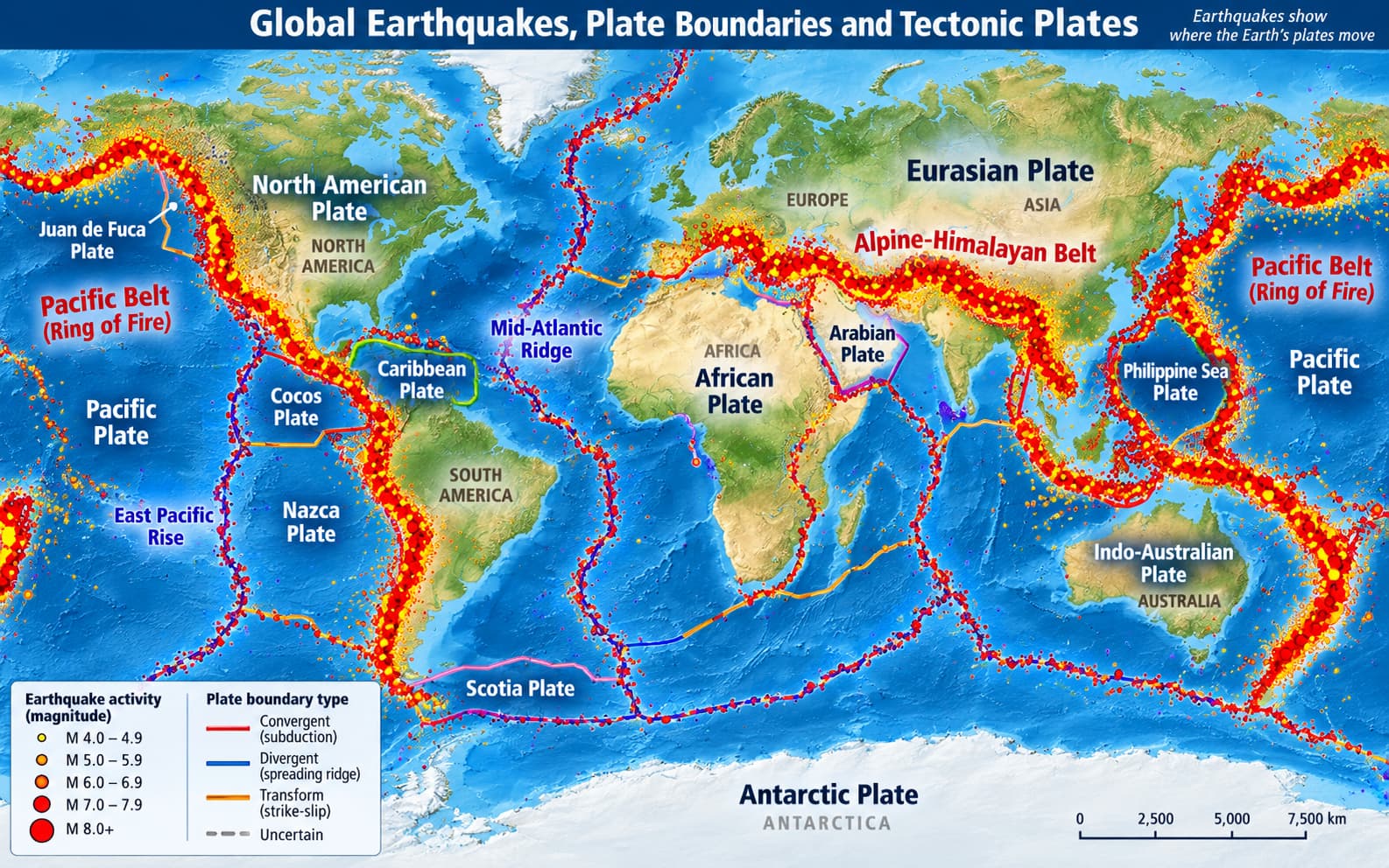
Earthquakes are strongly concentrated along tectonic plate boundaries.
Circum-Pacific Belt
Surrounds much of the Pacific and corresponds closely with the Ring of Fire.
Alpine-Himalayan Belt
Extends from the Mediterranean through West Asia and the Himalayas toward Southeast Asia.
Mid-Oceanic Ridges
Divergent plate boundaries are important zones of shallow earthquakes.
Plate Boundary Connection
Convergent: shallow, intermediate and deep earthquakes.
Divergent: mainly shallow earthquakes.
Transform: mainly shallow but potentially destructive earthquakes.
11. Earthquakes in India
Himalayan Region
Highly active because of continuing Indian–Eurasian convergence.
Northeastern India
Highly seismic because of complex tectonic interactions.
Kachchh
Major intraplate seismic region; site of the 2001 Bhuj earthquake.
Andaman & Nicobar
Highly active because of nearby subduction.
Peninsular India
Relatively stable but not earthquake-free; ancient faults can reactivate.
Seismic Zones of India
India is divided into Zones II, III, IV and V.
Zone II
Relatively lower hazard.
Zone III
Moderate hazard.
Zone IV
High hazard.
Zone V
Highest hazard.
Important Earthquakes Related to India
1897 Shillong • 1905 Kangra • 1934 Bihar–Nepal • 1950 Assam–Tibet • 1967 Koyna • 1993 Latur • 2001 Bhuj • 2004 Sumatra–Andaman earthquake and Indian Ocean Tsunami
12. Major Effects and Hazards
13. Prediction and Earthquake Early Warning
Scientists can identify earthquake-prone zones and estimate long-term seismic probability.
However, the exact time, place and magnitude of a future earthquake cannot currently be predicted reliably.
An Earthquake Early Warning System detects an earthquake after rupture has started. Because faster P waves arrive before more damaging waves, some places may receive a few seconds of warning.
14. Earthquake Risk Reduction
• Seismic hazard mapping and microzonation.
• Earthquake-resistant building design.
• Effective building codes.
• Retrofitting vulnerable structures.
• Safer land-use planning.
• Protection of critical infrastructure.
• Public awareness and emergency drills.
• Early-warning systems where feasible.
Quick Revision
• Focus lies inside Earth; epicentre lies above it on the surface.
• Tectonic earthquakes are the most common.
• Shallow: 0–70 km; intermediate: 70–300 km; deep: 300–700 km.
• P waves are fastest and pass through solids, liquids and gases.
• S waves pass only through solids.
• Surface waves are generally most destructive.
• P-wave shadow zone ≈ 105°–145°.
• S waves are absent beyond about 105°.
• Richter → magnitude; Modified Mercalli → intensity.
• +1 magnitude ≈ 10× amplitude and 31–32× energy.
• Mw is preferred for large earthquakes.
• Mercalli ranges from I–XII.
• Isoseismal lines join places of equal intensity.
• India has seismic Zones II, III, IV and V.
• Exact earthquake prediction is not currently reliable.
Think Like UPSC
Earthquakes should be linked directly with plate tectonics. Convergent, divergent and transform boundaries produce different earthquake patterns, while subduction zones can generate shallow, intermediate and deep earthquakes.
Also remember that magnitude describes the earthquake itself, whereas intensity describes its local effects. Therefore the same earthquake can produce very different damage in different places.