Structure of the Earth: Crust → Mantle → Core → Lithosphere → Asthenosphere → Major Discontinuities
The Earth may look like one solid body from outside, but its interior is divided into several layers that differ in composition, density, temperature and physical behaviour.
Understanding these layers is essential before studying plate tectonics, earthquakes and volcanoes.
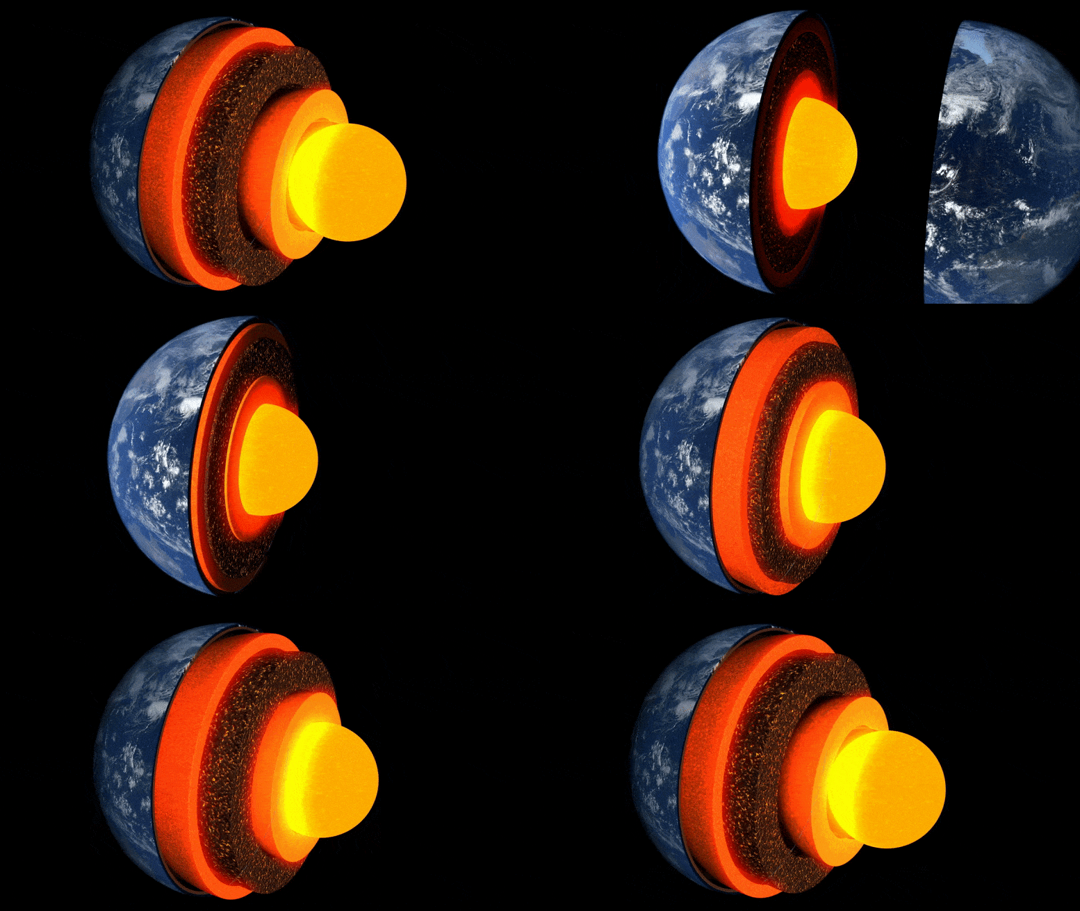
1. Two Ways to Divide the Earth's Interior
Scientists classify the Earth's interior in two different ways.
A. Compositional Classification
Based on what the Earth is made of.
B. Mechanical Classification
Based on how the material behaves — rigid, weak, plastic or liquid.
Most Important Concept: The crust and lithosphere are not the same. The lithosphere includes the entire crust plus the rigid uppermost part of the mantle.
2. Earth at a Glance
3. Journey from the Surface to the Centre
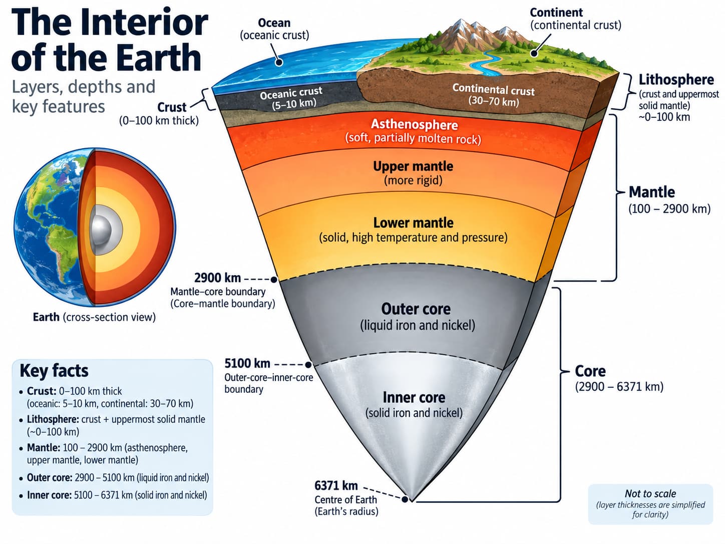
About 5–70 km
Extends to about 2,900 km depth
≈ 2,900–5,150 km | Liquid
≈ 5,150–6,371 km | Solid
4. Crust: The Thin Outer Skin of the Earth
The crust is the outermost solid and brittle layer of the Earth.
Compared with the total size of the Earth, it is extremely thin—similar to the thin skin of an apple.
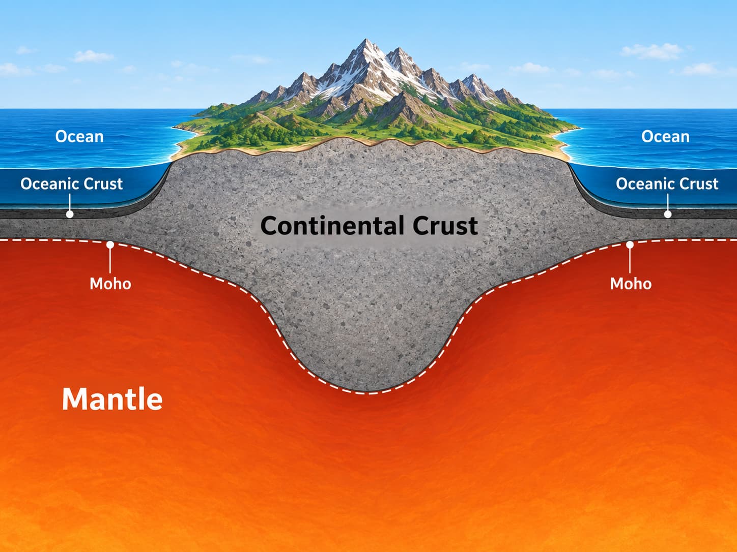
Continental Crust
Average thickness ≈ 30 km.
May reach around 70 km below major mountain systems such as the Himalayas.
Generally less dense.
Broadly granitic/felsic in character.
Contains some of the oldest rocks on Earth.
Oceanic Crust
Mean thickness ≈ 5 km.
Generally denser than continental crust.
Mainly basaltic/mafic in character.
Usually geologically younger than continental crust.
Continuously created and recycled through tectonic processes.
Traditional Exam Terms:
SIAL = Silica + Aluminium, traditionally associated with continental material.
SIMA = Silica + Magnesium, traditionally associated with denser oceanic material.
These are simplified traditional terms and should not be treated as exact modern compositional divisions.
5. Moho: Boundary between Crust and Mantle
The boundary between the crust and mantle is called the Mohorovičić Discontinuity, commonly known as the Moho.
It was identified through a sudden increase in the velocity of seismic waves, showing that the rocks below the crust were different from those above it.
It is named after Croatian seismologist Andrija Mohorovičić.
6. Mantle: The Thickest Major Layer
The mantle begins below the Moho and extends to approximately 2,900 km depth.
It forms roughly 84% of the Earth's volume, making it the largest major internal layer.
Composed mainly of silicate minerals rich in magnesium and iron.
Most mantle material is solid.
Because of extremely high temperature and pressure, mantle rocks can deform and flow very slowly over geological time.
Do not imagine the mantle as a giant sea of magma. Most of it is solid rock. Only certain regions may experience partial melting.
7. Upper Mantle and the Asthenosphere
The uppermost part of the mantle is relatively rigid, but below it lies a weaker zone called the asthenosphere.
The word astheno means weak.
NCERT broadly describes the asthenosphere as extending to about 400 km depth, although its exact depth and thickness vary from place to place.
It is mainly solid.
High temperature makes its rocks mechanically weak and capable of slow deformation.
A small amount of partial melting may occur in some regions.
The rigid lithosphere moves above this comparatively weaker zone.
8. Low Velocity Zone (LVZ)
A part of the upper mantle associated with the asthenosphere is known as the Low Velocity Zone.
Here, seismic-wave velocities become comparatively lower because the rocks are very hot and mechanically weak, and small amounts of partial melt may be present.
9. Mantle Transition Zone: 410–660 km
Between about 410 km and 660 km depth, mantle minerals undergo important changes because of increasing pressure.
This region is known as the mantle transition zone.
≈ 410 km
Important mineral phase changes begin.
≈ 660 km
Marks the major transition toward the lower mantle.
Older geography and competitive-examination texts may use the term Repetti Discontinuity for the broad upper–lower mantle transition. Modern geophysics more commonly refers to the 660-km discontinuity.
10. Lower Mantle
Below the transition zone lies the lower mantle, extending roughly from 660 km to 2,900 km.
Although temperature is very high, enormous pressure keeps the material mostly solid and mechanically stronger than the asthenosphere.
Advanced Term: In mechanical classifications, the stronger mantle below the asthenosphere is sometimes called the mesosphere. Do not confuse it with the atmospheric mesosphere.
11. Core: The Metallic Centre of the Earth
The core begins at approximately 2,900 km depth and extends to the centre of the Earth.
It is composed mainly of iron and nickel. In traditional geography terminology this is often remembered as NIFE = Nickel + Iron.
Outer Core
Depth: approximately 2,900–5,150 km.
Liquid in physical state.
Mainly iron and nickel with lighter elements.
Movement of electrically conducting liquid metal helps generate the Earth's magnetic field.
Inner Core
Depth: approximately 5,150–6,371 km.
Solid in physical state.
Mainly iron and nickel.
Extremely high pressure keeps it solid despite very high temperature.
Easy Logic: Outer Core = extremely hot + comparatively lower pressure → liquid.
Inner Core = even greater pressure → material remains solid.
12. Lithosphere: The Rigid Outer Shell
The lithosphere is the rigid outer mechanical layer of the Earth.
It is strong, rigid and brittle.
NCERT gives its thickness broadly as about 10–200 km.
Its thickness varies greatly from place to place.
It is divided into several large and small tectonic plates.
13. Lithosphere and Asthenosphere: Understand the Difference
Lithosphere
Rigid
Crust + uppermost rigid mantle
Broken into tectonic plates
Asthenosphere
Weak and deformable
Part of upper mantle
Allows slow movement of lithospheric plates above it
14. What is a Discontinuity?
A discontinuity is a boundary inside the Earth where the properties of material change significantly.
When seismic waves cross such a boundary, their speed, direction or behaviour changes.
15. Major Discontinuities of the Earth
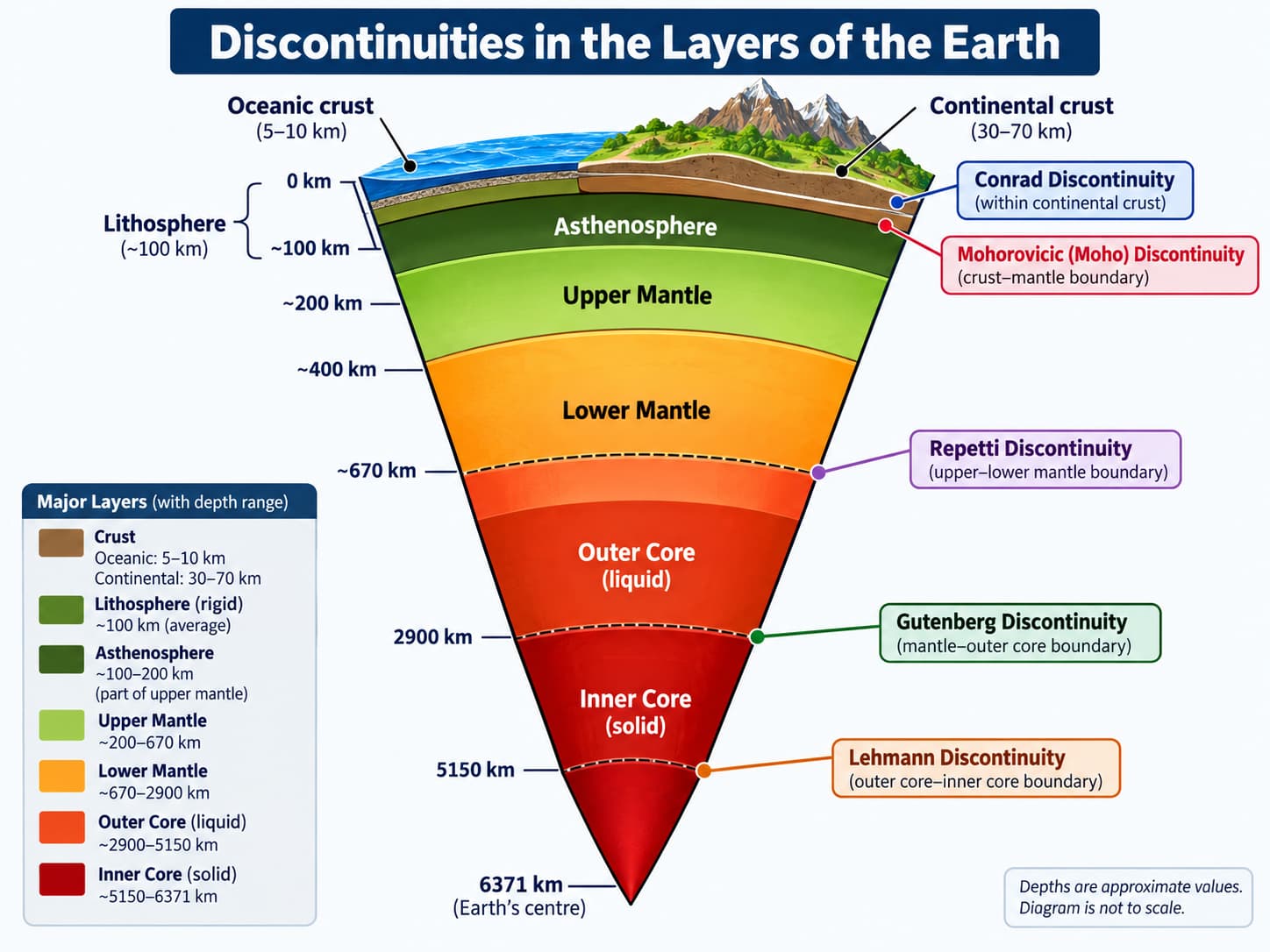
Conrad Discontinuity
Traditionally described as a boundary between upper and lower parts of the continental crust.
It is not a continuous global boundary and is generally not recognised beneath oceanic crust.
Mohorovičić Discontinuity — Moho
Separates the crust from the mantle.
It lies much deeper beneath continents and mountain systems than beneath oceans.
410 km and 660 km Discontinuities
Mark important mineral changes within the mantle transition zone.
Older exam literature may associate the broad upper–lower mantle transition with the Repetti Discontinuity.
Gutenberg Discontinuity
Located at about 2,900 km depth.
Separates the mantle from the liquid outer core.
S-waves do not pass through the liquid outer core, while P-waves undergo strong refraction.
Lehmann / Inner-Core Boundary
Located at about 5,150 km depth.
Separates the liquid outer core from the solid inner core.
The discovery of the solid inner core is closely associated with Danish seismologist Inge Lehmann.
Easy Boundary Sequence
Conrad → within continental crust
Moho → Crust–Mantle
410–660 km → Mantle Transition Zone
Gutenberg → Mantle–Outer Core
Lehmann → Outer Core–Inner Core
16. Put the Entire Structure Together
Weak and deformable upper mantle
to about 2,900 km
17. Common Confusions to Avoid
No. Lithosphere = crust + rigid uppermost mantle.
No. Most of the mantle is solid and flows only very slowly over geological time.
No. It is mainly solid but mechanically weak and deformable.
No. Outer core is liquid, while inner core is solid.
No. Extremely high pressure keeps the inner core solid.
18. Why the Earth's Internal Structure Matters
The Earth's internal heat and differences in physical behaviour of its layers are the foundation of many major geological processes.
We will study these processes separately in the coming posts so that concepts do not get mixed or repeated.
Quick Revision
Mean radius of Earth ≈ 6,371 km.
Compositional layers: Crust → Mantle → Core.
Oceanic crust ≈ 5 km; continental crust ≈ 30 km.
Continental crust may reach around 70 km beneath major mountain systems.
Moho separates crust and mantle.
Mantle extends to about 2,900 km.
Asthenosphere is weak, deformable and associated with the Low Velocity Zone.
NCERT broadly places the asthenosphere up to about 400 km.
410–660 km = mantle transition zone.
Lithosphere = Crust + rigid uppermost mantle.
NCERT gives lithosphere thickness broadly as 10–200 km.
Core is mainly iron + nickel (NIFE).
Outer Core = Liquid | Inner Core = Solid.
Gutenberg = Mantle–Outer Core boundary.
Lehmann = Outer Core–Inner Core boundary.
Think Like UPSC
If a statement says “Lithosphere consists only of the Earth's crust”, it is incorrect because the lithosphere also includes the rigid uppermost mantle.
If a statement says “Asthenosphere is a completely molten layer”, it is also incorrect. It is mainly solid but weak and capable of slow deformation.
Remember the most important physical-state sequence: Rigid Lithosphere → Weak Asthenosphere → Solid Deeper Mantle → Liquid Outer Core → Solid Inner Core.
पृथ्वी की संरचना: भूपर्पटी → मैंटल → क्रोड → स्थलमंडल → दुर्बलतामंडल → प्रमुख असांतत्य
बाहर से पृथ्वी एक ठोस पिंड जैसी दिखाई देती है, लेकिन इसका आंतरिक भाग कई परतों में विभाजित है, जो संरचना, घनत्व, तापमान और भौतिक व्यवहार में एक-दूसरे से भिन्न हैं।
प्लेट विवर्तनिकी, भूकंप और ज्वालामुखियों का अध्ययन करने से पहले इन परतों को समझना आवश्यक है।
1. पृथ्वी के आंतरिक भाग को विभाजित करने के दो तरीके
वैज्ञानिक पृथ्वी के आंतरिक भाग का वर्गीकरण दो अलग-अलग तरीकों से करते हैं।
A. संघटनात्मक वर्गीकरण
यह इस आधार पर किया जाता है कि पृथ्वी किन पदार्थों से बनी है।
B. यांत्रिक वर्गीकरण
यह इस आधार पर किया जाता है कि पदार्थ किस प्रकार व्यवहार करता है — कठोर, कमजोर, प्लास्टिक या द्रव।
सबसे महत्त्वपूर्ण अवधारणा: भूपर्पटी और स्थलमंडल एक ही नहीं हैं। स्थलमंडल में संपूर्ण भूपर्पटी के साथ मैंटल का सबसे ऊपरी कठोर भाग भी शामिल होता है।
2. पृथ्वी एक दृष्टि में
```
3. सतह से केंद्र तक की यात्रा
लगभग 5–70 किमी
लगभग 2,900 किमी की गहराई तक
≈ 2,900–5,150 किमी | द्रव
≈ 5,150–6,371 किमी | ठोस
4. भूपर्पटी: पृथ्वी की पतली बाहरी परत
भूपर्पटी पृथ्वी की सबसे बाहरी ठोस और भंगुर परत है।
पृथ्वी के कुल आकार की तुलना में यह अत्यंत पतली है—लगभग सेब के पतले छिलके के समान।
महाद्वीपीय भूपर्पटी
औसत मोटाई ≈ 30 किमी।
हिमालय जैसी प्रमुख पर्वत प्रणालियों के नीचे यह लगभग 70 किमी तक पहुँच सकती है।
सामान्यतः कम घनत्व वाली होती है।
व्यापक रूप से ग्रेनाइटिक/फेल्सिक प्रकृति की होती है।
पृथ्वी की कुछ सबसे प्राचीन चट्टानें इसी में पाई जाती हैं।
महासागरीय भूपर्पटी
औसत मोटाई ≈ 5 किमी।
सामान्यतः महाद्वीपीय भूपर्पटी की तुलना में अधिक घनत्व वाली होती है।
मुख्यतः बेसाल्टिक/मैफिक प्रकृति की होती है।
भूगर्भीय दृष्टि से सामान्यतः महाद्वीपीय भूपर्पटी से नई होती है।
विवर्तनिक प्रक्रियाओं द्वारा लगातार बनती और पुनर्चक्रित होती रहती है।
पारंपरिक परीक्षा शब्द:
SIAL = Silica + Aluminium, परंपरागत रूप से महाद्वीपीय पदार्थ से संबंधित।
SIMA = Silica + Magnesium, परंपरागत रूप से अधिक घनत्व वाले महासागरीय पदार्थ से संबंधित।
ये सरल पारंपरिक शब्द हैं और इन्हें आधुनिक संघटनात्मक विभाजनों का बिल्कुल सटीक रूप नहीं माना जाना चाहिए।
5. मोहो: भूपर्पटी और मैंटल के बीच की सीमा
भूपर्पटी और मैंटल के बीच की सीमा को मोहोरोविचिक असांतत्य (Mohorovičić Discontinuity) कहा जाता है, जिसे सामान्यतः मोहो (Moho) कहा जाता है।
इसकी पहचान भूकंपीय तरंगों के वेग में अचानक वृद्धि से हुई, जिससे ज्ञात हुआ कि भूपर्पटी के नीचे की चट्टानें ऊपर की चट्टानों से भिन्न हैं।
इसका नाम क्रोएशियाई भूकंप विज्ञानी आंद्रिजा मोहोरोविचिक (Andrija Mohorovičić) के नाम पर रखा गया है।
6. मैंटल: सबसे मोटी प्रमुख परत
मैंटल मोहो के नीचे से शुरू होता है और लगभग 2,900 किमी की गहराई तक फैला होता है।
यह पृथ्वी के आयतन का लगभग 84% भाग बनाता है, इसलिए यह पृथ्वी की सबसे बड़ी प्रमुख आंतरिक परत है।
यह मुख्यतः मैग्नीशियम और लौह से समृद्ध सिलिकेट खनिजों से बना है।
मैंटल का अधिकांश पदार्थ ठोस होता है।
अत्यधिक तापमान और दाब के कारण मैंटल की चट्टानें भूगर्भीय समय में बहुत धीरे-धीरे विकृत होकर प्रवाहित हो सकती हैं।
मैंटल को मैग्मा के विशाल समुद्र के रूप में न समझें। इसका अधिकांश भाग ठोस चट्टानों का है। केवल कुछ क्षेत्रों में आंशिक गलन हो सकती है।
7. ऊपरी मैंटल और दुर्बलतामंडल
मैंटल का सबसे ऊपरी भाग अपेक्षाकृत कठोर होता है, लेकिन इसके नीचे एक अपेक्षाकृत कमजोर क्षेत्र पाया जाता है जिसे दुर्बलतामंडल (Asthenosphere) कहा जाता है।
Astheno शब्द का अर्थ कमजोर होता है।
NCERT के अनुसार दुर्बलतामंडल मोटे तौर पर लगभग 400 किमी की गहराई तक विस्तृत माना जाता है, यद्यपि इसकी वास्तविक गहराई और मोटाई स्थान-स्थान पर भिन्न हो सकती है।
यह मुख्यतः ठोस होता है।
उच्च तापमान इसकी चट्टानों को यांत्रिक रूप से कमजोर और धीरे-धीरे विकृत होने योग्य बनाता है।
कुछ क्षेत्रों में थोड़ी मात्रा में आंशिक गलन हो सकती है।
कठोर स्थलमंडल इसी अपेक्षाकृत कमजोर क्षेत्र के ऊपर गति करता है।
8. निम्न वेग क्षेत्र (Low Velocity Zone — LVZ)
दुर्बलतामंडल से संबंधित ऊपरी मैंटल के एक भाग को निम्न वेग क्षेत्र (Low Velocity Zone) कहा जाता है।
यहाँ भूकंपीय तरंगों का वेग तुलनात्मक रूप से कम हो जाता है क्योंकि चट्टानें अत्यधिक गर्म और यांत्रिक रूप से कमजोर होती हैं तथा कुछ मात्रा में आंशिक गलन भी उपस्थित हो सकती है।
9. मैंटल संक्रमण क्षेत्र: 410–660 किमी
लगभग 410 किमी से 660 किमी की गहराई के बीच बढ़ते दाब के कारण मैंटल के खनिजों में महत्त्वपूर्ण परिवर्तन होते हैं।
इस क्षेत्र को मैंटल संक्रमण क्षेत्र (Mantle Transition Zone) कहा जाता है।
≈ 410 किमी
महत्त्वपूर्ण खनिजीय अवस्था परिवर्तन प्रारंभ होते हैं।
≈ 660 किमी
निम्न मैंटल की ओर प्रमुख संक्रमण को दर्शाता है।
पुराने भूगोल और प्रतियोगी परीक्षा के ग्रंथों में ऊपरी और निम्न मैंटल के व्यापक संक्रमण के लिए रेपेटी असांतत्य (Repetti Discontinuity) शब्द का प्रयोग किया जा सकता है। आधुनिक भूभौतिकी में सामान्यतः 660-किमी असांतत्य का उल्लेख किया जाता है।
10. निम्न मैंटल
संक्रमण क्षेत्र के नीचे निम्न मैंटल स्थित है, जो लगभग 660 किमी से 2,900 किमी तक फैला हुआ है।
यद्यपि यहाँ तापमान अत्यंत अधिक होता है, फिर भी अत्यधिक दाब पदार्थ को अधिकांशतः ठोस बनाए रखता है और यह दुर्बलतामंडल की तुलना में यांत्रिक रूप से अधिक मजबूत होता है।
उन्नत शब्द: यांत्रिक वर्गीकरण में दुर्बलतामंडल के नीचे स्थित अधिक मजबूत मैंटल को कभी-कभी मध्यमंडल (Mesosphere) कहा जाता है। इसे वायुमंडल के मध्यमंडल से भ्रमित न करें।
```
11. क्रोड: पृथ्वी का धात्विक केंद्र
क्रोड लगभग 2,900 किमी की गहराई से प्रारंभ होता है और पृथ्वी के केंद्र तक विस्तृत है।
यह मुख्यतः लौह और निकेल से बना है। पारंपरिक भूगोल में इसे अक्सर NIFE = Nickel + Iron के रूप में याद किया जाता है।
बाह्य क्रोड
गहराई: लगभग 2,900–5,150 किमी।
भौतिक अवस्था में द्रव।
मुख्यतः लौह और निकेल के साथ कुछ हल्के तत्व।
विद्युत चालक द्रव धातु की गति पृथ्वी के चुंबकीय क्षेत्र के निर्माण में सहायता करती है।
आंतरिक क्रोड
गहराई: लगभग 5,150–6,371 किमी।
भौतिक अवस्था में ठोस।
मुख्यतः लौह और निकेल से बना है।
अत्यधिक तापमान के बावजूद अत्यधिक दाब इसे ठोस बनाए रखता है।
सरल तर्क: बाह्य क्रोड = अत्यधिक तापमान + तुलनात्मक रूप से कम दाब → द्रव।
आंतरिक क्रोड = और भी अधिक दाब → पदार्थ ठोस बना रहता है।
12. स्थलमंडल: कठोर बाहरी आवरण
स्थलमंडल पृथ्वी की कठोर बाहरी यांत्रिक परत है।
यह मजबूत, कठोर और भंगुर होता है।
NCERT इसकी मोटाई व्यापक रूप से लगभग 10–200 किमी बताती है।
इसकी मोटाई स्थान-स्थान पर बहुत भिन्न होती है।
यह कई बड़ी और छोटी विवर्तनिक प्लेटों में विभाजित है।
13. स्थलमंडल और दुर्बलतामंडल: अंतर समझें
स्थलमंडल
कठोर
भूपर्पटी + सबसे ऊपरी कठोर मैंटल
विवर्तनिक प्लेटों में विभाजित
दुर्बलतामंडल
कमजोर और विकृत होने योग्य
ऊपरी मैंटल का भाग
ऊपर स्थित स्थलमंडलीय प्लेटों की धीमी गति को संभव बनाता है
14. असांतत्य क्या है?
असांतत्य (Discontinuity) पृथ्वी के भीतर वह सीमा है जहाँ पदार्थ के गुणों में महत्त्वपूर्ण परिवर्तन होता है।
जब भूकंपीय तरंगें ऐसी सीमा को पार करती हैं, तो उनकी गति, दिशा या व्यवहार बदल जाता है।
15. पृथ्वी के प्रमुख असांतत्य
कॉनराड असांतत्य
पारंपरिक रूप से इसे महाद्वीपीय भूपर्पटी के ऊपरी और निचले भागों के बीच की सीमा माना जाता है।
यह निरंतर वैश्विक सीमा नहीं है और सामान्यतः महासागरीय भूपर्पटी के नीचे मान्यता प्राप्त नहीं है।
मोहोरोविचिक असांतत्य — मोहो
यह भूपर्पटी को मैंटल से अलग करता है।
महासागरों की तुलना में महाद्वीपों और पर्वतीय क्षेत्रों के नीचे यह अधिक गहराई पर स्थित होता है।
410 किमी और 660 किमी असांतत्य
ये मैंटल संक्रमण क्षेत्र के भीतर महत्त्वपूर्ण खनिजीय परिवर्तनों को दर्शाते हैं।
पुराने परीक्षा साहित्य में ऊपरी और निम्न मैंटल के व्यापक संक्रमण को रेपेटी असांतत्य से जोड़ा जा सकता है।
गुटेनबर्ग असांतत्य
यह लगभग 2,900 किमी की गहराई पर स्थित है।
यह मैंटल को द्रव बाह्य क्रोड से अलग करता है।
S-तरंगें द्रव बाह्य क्रोड से होकर नहीं गुजरतीं, जबकि P-तरंगों का तीव्र अपवर्तन होता है।
लेहमैन / आंतरिक क्रोड सीमा
यह लगभग 5,150 किमी की गहराई पर स्थित है।
यह द्रव बाह्य क्रोड को ठोस आंतरिक क्रोड से अलग करता है।
ठोस आंतरिक क्रोड की खोज डेनमार्क की भूकंप विज्ञानी इंगे लेहमैन (Inge Lehmann) से निकटता से जुड़ी है।
सीमाओं का आसान क्रम
कॉनराड → महाद्वीपीय भूपर्पटी के भीतर
मोहो → भूपर्पटी–मैंटल
410–660 किमी → मैंटल संक्रमण क्षेत्र
गुटेनबर्ग → मैंटल–बाह्य क्रोड
लेहमैन → बाह्य क्रोड–आंतरिक क्रोड
16. संपूर्ण संरचना को एक साथ समझें
कमजोर और विकृत होने योग्य ऊपरी मैंटल
लगभग 2,900 किमी तक
17. सामान्य भ्रम जिनसे बचना चाहिए
नहीं। स्थलमंडल = भूपर्पटी + सबसे ऊपरी कठोर मैंटल।
नहीं। मैंटल का अधिकांश भाग ठोस है और भूगर्भीय समय में केवल बहुत धीरे-धीरे प्रवाहित होता है।
नहीं। यह मुख्यतः ठोस है, लेकिन यांत्रिक रूप से कमजोर और विकृत होने योग्य है।
नहीं। बाह्य क्रोड द्रव है, जबकि आंतरिक क्रोड ठोस है।
नहीं। अत्यधिक दाब आंतरिक क्रोड को ठोस बनाए रखता है।
18. पृथ्वी की आंतरिक संरचना क्यों महत्त्वपूर्ण है?
पृथ्वी की आंतरिक ऊष्मा और इसकी विभिन्न परतों के भौतिक व्यवहार में अंतर कई प्रमुख भूगर्भीय प्रक्रियाओं का आधार है।
इन प्रक्रियाओं का अध्ययन आने वाले पोस्टों में अलग-अलग किया जाएगा, ताकि अवधारणाएँ आपस में न मिलें और अनावश्यक पुनरावृत्ति न हो।
त्वरित पुनरावृत्ति
पृथ्वी की औसत त्रिज्या ≈ 6,371 किमी।
संघटनात्मक परतें: भूपर्पटी → मैंटल → क्रोड।
महासागरीय भूपर्पटी ≈ 5 किमी; महाद्वीपीय भूपर्पटी ≈ 30 किमी।
महाद्वीपीय भूपर्पटी प्रमुख पर्वतीय क्षेत्रों के नीचे लगभग 70 किमी तक पहुँच सकती है।
मोहो भूपर्पटी और मैंटल को अलग करता है।
मैंटल लगभग 2,900 किमी की गहराई तक फैला है।
दुर्बलतामंडल कमजोर, विकृत होने योग्य और निम्न वेग क्षेत्र से संबंधित है।
NCERT दुर्बलतामंडल को व्यापक रूप से लगभग 400 किमी तक मानती है।
410–660 किमी = मैंटल संक्रमण क्षेत्र।
स्थलमंडल = भूपर्पटी + सबसे ऊपरी कठोर मैंटल।
NCERT स्थलमंडल की मोटाई व्यापक रूप से 10–200 किमी बताती है।
क्रोड मुख्यतः लौह + निकेल (NIFE) से बना है।
बाह्य क्रोड = द्रव | आंतरिक क्रोड = ठोस।
गुटेनबर्ग = मैंटल–बाह्य क्रोड सीमा।
लेहमैन = बाह्य क्रोड–आंतरिक क्रोड सीमा।
UPSC की तरह सोचें
यदि किसी कथन में कहा जाए कि “स्थलमंडल केवल पृथ्वी की भूपर्पटी से मिलकर बना है”, तो यह गलत है क्योंकि स्थलमंडल में मैंटल का सबसे ऊपरी कठोर भाग भी शामिल होता है।
यदि किसी कथन में कहा जाए कि “दुर्बलतामंडल पूर्णतः पिघली हुई परत है”, तो यह भी गलत है। यह मुख्यतः ठोस है, लेकिन कमजोर है और धीरे-धीरे विकृत हो सकता है।
सबसे महत्त्वपूर्ण भौतिक अवस्था क्रम याद रखें: कठोर स्थलमंडल → कमजोर दुर्बलतामंडल → ठोस गहरा मैंटल → द्रव बाह्य क्रोड → ठोस आंतरिक क्रोड।
```
```