Isostasy: Why Mountains Stand High and the Crust Adjusts Vertically
The Earth's crust is not simply resting on a fixed solid foundation. The rigid lithosphere is supported by the weaker, slowly deforming mantle beneath it.
The tendency of different parts of the Earth's crust to maintain gravitational balance is called isostasy.
1. What is Isostasy?
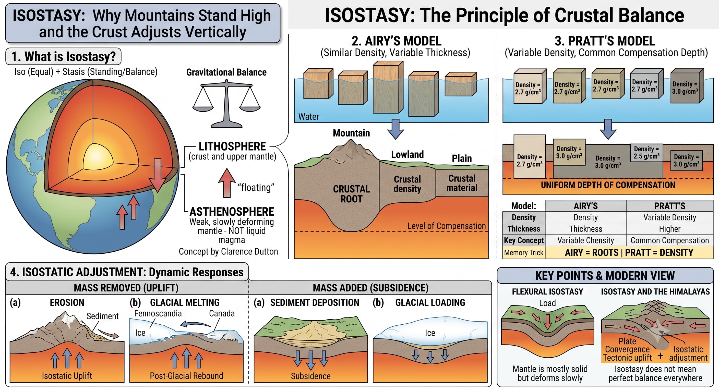
Isostasy is the state of gravitational balance in which blocks of the Earth's lithosphere are supported by the weaker material beneath them.
In very simple terms, the lithosphere behaves somewhat like objects floating at different levels according to their thickness and density.
2. Meaning of the Word
The term Isostasy was introduced by American geologist Clarence Dutton in the late nineteenth century.
It comes from Greek words broadly meaning:
Equal
Standing / Balance
3. Understand Isostasy with a Simple Example
Imagine pieces of wood floating in water.
A thick wooden block rises higher above water but also extends deeper below it.
A thinner block remains lower and has a shallower submerged portion.
Their final position depends on their thickness and density.
But remember: Earth's continents are not literally floating on an ocean of liquid magma. The mantle is mainly solid, but it can deform extremely slowly over geological time.
4. Why Do High Mountains Need Deep Roots?
Large mountain ranges such as the Himalayas contain enormous volumes of relatively low-density continental crust.
Their visible height above the surface is therefore accompanied by a thickened crust extending downward into the mantle.
This deep crustal root helps maintain gravitational balance.
5. Level of Compensation
Classical theories of isostasy imagine a depth below which the pressure produced by overlying crustal columns becomes approximately balanced.
This conceptual depth is called the level or depth of compensation.
6. Two Classical Models of Isostasy
Two classical explanations are especially important for competitive examinations: Airy's Model and Pratt's Model.
Airy's Theory
Proposed by George Biddell Airy.
He assumed that crustal blocks have broadly similar density but different thicknesses.
Therefore, high mountains possess deep crustal roots.
Pratt's Theory
Proposed by John Henry Pratt.
He explained relief mainly through differences in density, with crustal columns extending to a common depth of compensation.
Higher regions are made of comparatively lower-density material, while lower regions are relatively denser.
7. Airy's Model in the Easiest Possible Way
Think of several blocks made from the same type of wood floating in water.
Because their density is the same, the taller block must extend deeper into the water.
This model is particularly useful for understanding the thick continental crust beneath major mountain systems.
8. Pratt's Model in the Easiest Possible Way
Now imagine blocks reaching approximately the same depth, but having different densities.
The lower-density material occupies greater volume and therefore forms higher terrain.
Lower Region → Greater Density
9. Airy vs Pratt: Never Confuse Them
Airy
Density: broadly same
Thickness: varies
Mountain: deep root
Key idea: relief due mainly to thickness
Pratt
Density: varies
Compensation depth: broadly common
High region: lower density
Key idea: relief due mainly to density
Memory Trick: AIRY = ROOT | PRATT = DENSITY
10. Modern View: Flexural Isostasy
In reality, the lithosphere is not made of completely independent vertical blocks.
It has strength and can bend over a broad region when loaded. This behaviour is called flexural isostasy.
Load removed → Lithosphere tends to rise
Airy and Pratt remain very useful conceptual models, but actual Earth behaviour may involve both density differences and lithospheric flexure.
11. Isostatic Adjustment
Isostatic equilibrium can be disturbed when large amounts of mass are added or removed.
The crust then moves vertically to establish a new balance. This process is known as isostatic adjustment.
Mass Removed
Erosion or melting of glaciers reduces the load → crust tends to rise.
Mass Added
Thick sediments, ice or volcanic material add load → lithosphere tends to subside.
12. Erosion and Isostatic Uplift
Mountains continuously lose material through weathering and erosion.
As mass is removed, the crust becomes lighter and may rise slowly to restore equilibrium.
This is one reason old mountain regions may continue to experience uplift even while erosion lowers their surface.
13. Deposition and Subsidence
Rivers transport enormous amounts of sediments from mountains and deposit them in plains, deltas and ocean basins.
This additional weight can bend or push the lithosphere downward.
14. Glacial Isostatic Adjustment
During the Ice Ages, enormous ice sheets covered parts of northern Europe and North America.
Their weight pushed the lithosphere downward.
↓
Ice melts → Load removed → Crust slowly rises
This slow uplift after removal of ice is called post-glacial rebound or glacial isostatic adjustment.
It is especially evident in regions such as Fennoscandia and parts of Canada.
15. Isostasy and the Himalayas
The Himalayas have exceptionally thick continental crust produced by the collision of the Indian and Eurasian plates.
Much of this thickened crust extends downward as a deep crustal root.
At the same time, rivers continuously remove enormous quantities of material from the Himalayas.
Himalayan uplift is not caused by isostasy alone.
Plate convergence is the fundamental tectonic cause, while isostatic adjustment contributes to vertical crustal response as material is thickened or removed.
16. Isostasy and Gravity Anomalies
If mountains consisted simply of huge masses sitting above normal crust, gravity over them should be much stronger than observed.
Measurements showed that many mountain regions contain low-density crustal material extending to greater depth, helping explain these gravity anomalies.
Such gravity observations played an important role in the development of classical ideas of isostatic compensation.
17. Isostasy Does Not Mean Perfect Balance Everywhere
Earth is continuously changing because of:
Plate collision
Mountain building
Erosion
Sediment deposition
Glacial loading and melting
Volcanic loading
Therefore, some regions may temporarily be out of isostatic equilibrium and continue adjusting over thousands or millions of years.
18. Common Confusions to Avoid
Incorrect. The mantle is mostly solid but can deform slowly over geological time.
Incorrect. Isostasy mainly explains vertical gravitational adjustment; plate tectonics explains large-scale movement of lithospheric plates.
Incorrect. The crust may rise or sink while trying to restore gravitational balance.
Incorrect. Actual Earth behaviour combines crustal thickness, density variations and lithospheric flexure.
19. The Complete Concept in One Flow
↓
Weak mantle supports it
↓
Thickness + Density determine equilibrium
↓
Mass added → Subsidence
↕
Mass removed → Uplift
Quick Revision
Isostasy = gravitational balance of the lithosphere over weaker underlying mantle.
Term associated with Clarence Dutton.
Mountains generally have thick crustal material extending downward.
Airy: similar density, variable thickness.
Pratt: variable density, broadly common compensation depth.
Memory rule: Airy = Roots | Pratt = Density.
Modern understanding also includes flexural isostasy.
Removal of mass by erosion or melting of glaciers → isostatic uplift.
Addition of sediments, ice or volcanic load → subsidence.
Post-glacial uplift is prominent in Fennoscandia and Canada.
Himalayas involve both plate convergence and isostatic adjustment.
Think Like UPSC
Suppose a large ice sheet melts from a continental region. What should happen in the long term?
Similarly, continuous erosion of a mountain removes mass and may produce isostatic uplift, while heavy sediment accumulation may cause subsidence.
↓
Post 2: Crust, Mantle, Core, Lithosphere, Asthenosphere & Discontinuities
↓
Post 3: Isostasy & Isostatic Adjustment
समस्थिति (Isostasy): पर्वत इतने ऊँचे क्यों हैं और भूपर्पटी ऊर्ध्वाधर रूप से समायोजित क्यों होती है?
पृथ्वी की भूपर्पटी किसी स्थिर ठोस आधार पर केवल टिकी हुई नहीं है। कठोर स्थलमंडल (Lithosphere) को उसके नीचे स्थित अपेक्षाकृत कमजोर और अत्यंत धीमी गति से विकृत होने वाला मैंटल सहारा देता है।
पृथ्वी की भूपर्पटी के विभिन्न भागों की गुरुत्वीय संतुलन बनाए रखने की प्रवृत्ति को समस्थिति (Isostasy) कहा जाता है।
1. समस्थिति (Isostasy) क्या है?
समस्थिति गुरुत्वीय संतुलन की वह अवस्था है जिसमें पृथ्वी के स्थलमंडल के विभिन्न खंडों को उनके नीचे स्थित अपेक्षाकृत कमजोर पदार्थ द्वारा सहारा मिलता है।
बहुत सरल शब्दों में, स्थलमंडल कुछ हद तक ऐसे तैरते हुए पिंडों की तरह व्यवहार करता है जिनका स्तर उनकी मोटाई और घनत्व पर निर्भर करता है।
2. शब्द का अर्थ
Isostasy शब्द का प्रयोग अमेरिकी भूवैज्ञानिक क्लेरेंस डटन (Clarence Dutton) ने उन्नीसवीं शताब्दी के उत्तरार्ध में किया।
यह ग्रीक भाषा के शब्दों से बना है, जिनका व्यापक अर्थ है:
समान
स्थिति / संतुलन
3. एक सरल उदाहरण से समस्थिति को समझें
कल्पना कीजिए कि लकड़ी के कुछ टुकड़े पानी पर तैर रहे हैं।
लकड़ी का मोटा खंड पानी की सतह से अधिक ऊपर उठता है, लेकिन उसका बड़ा भाग पानी के भीतर भी अधिक गहराई तक जाता है।
पतला खंड अपेक्षाकृत नीचे रहता है और उसका डूबा हुआ भाग भी कम गहरा होता है।
उनकी अंतिम स्थिति उनकी मोटाई और घनत्व पर निर्भर करती है।
लेकिन याद रखें: महाद्वीप वास्तव में द्रव मैग्मा के महासागर पर नहीं तैर रहे हैं। मैंटल मुख्यतः ठोस है, लेकिन भूवैज्ञानिक समय में यह अत्यंत धीमी गति से विकृत हो सकता है।
4. ऊँचे पर्वतों को गहरी जड़ों की आवश्यकता क्यों होती है?
हिमालय जैसी विशाल पर्वत शृंखलाओं में अपेक्षाकृत कम घनत्व वाली महाद्वीपीय भूपर्पटी का बहुत बड़ा आयतन पाया जाता है।
इसलिए सतह के ऊपर दिखाई देने वाली उनकी विशाल ऊँचाई के साथ नीचे की ओर मैंटल में फैली हुई मोटी भूपर्पटी भी होती है।
यह गहरी भूपर्पटीय जड़ गुरुत्वीय संतुलन बनाए रखने में सहायता करती है।
5. क्षतिपूर्ति स्तर (Level of Compensation)
समस्थिति के शास्त्रीय सिद्धांत एक ऐसी गहराई की कल्पना करते हैं जिसके नीचे ऊपर स्थित विभिन्न भूपर्पटीय स्तंभों द्वारा उत्पन्न दबाव लगभग संतुलित हो जाता है।
इस काल्पनिक गहराई को क्षतिपूर्ति स्तर या क्षतिपूर्ति की गहराई (Level or Depth of Compensation) कहा जाता है।
6. समस्थिति के दो शास्त्रीय मॉडल
प्रतियोगी परीक्षाओं के लिए दो शास्त्रीय व्याख्याएँ विशेष रूप से महत्त्वपूर्ण हैं: एयरी का मॉडल (Airy's Model) और प्रैट का मॉडल (Pratt's Model)।
एयरी का सिद्धांत
इसे जॉर्ज बिडेल एयरी (George Biddell Airy) ने प्रस्तुत किया।
उन्होंने माना कि भूपर्पटीय खंडों का घनत्व लगभग समान होता है, लेकिन उनकी मोटाई अलग-अलग होती है।
इसलिए ऊँचे पर्वतों के नीचे गहरी भूपर्पटीय जड़ें होती हैं।
प्रैट का सिद्धांत
इसे जॉन हेनरी प्रैट (John Henry Pratt) ने प्रस्तुत किया।
उन्होंने स्थलाकृति की ऊँचाई में अंतर को मुख्यतः घनत्व में अंतर के आधार पर समझाया, जबकि विभिन्न भूपर्पटीय स्तंभ लगभग समान क्षतिपूर्ति गहराई तक विस्तृत माने गए।
ऊँचे क्षेत्र अपेक्षाकृत कम घनत्व वाले पदार्थ से बने होते हैं, जबकि नीचे स्थित क्षेत्र अपेक्षाकृत अधिक घनत्व वाले होते हैं।
7. एयरी के मॉडल को सबसे सरल तरीके से समझें
पानी में तैर रहे एक ही प्रकार की लकड़ी से बने कई खंडों की कल्पना कीजिए।
चूँकि उनका घनत्व समान है, इसलिए अधिक ऊँचा खंड पानी के भीतर भी अधिक गहराई तक जाएगा।
यह मॉडल प्रमुख पर्वतीय क्षेत्रों के नीचे पाई जाने वाली मोटी महाद्वीपीय भूपर्पटी को समझने में विशेष रूप से उपयोगी है।
8. प्रैट के मॉडल को सबसे सरल तरीके से समझें
अब ऐसे खंडों की कल्पना कीजिए जो लगभग समान गहराई तक पहुँचते हैं, लेकिन उनके घनत्व अलग-अलग हैं।
कम घनत्व वाला पदार्थ अधिक आयतन घेरता है और इसलिए अधिक ऊँचा भू-भाग बनाता है।
निचला क्षेत्र → अधिक घनत्व
9. एयरी बनाम प्रैट: कभी भ्रमित न हों
एयरी
घनत्व: लगभग समान
मोटाई: अलग-अलग
पर्वत: गहरी जड़
मुख्य विचार: स्थलरूप में अंतर मुख्यतः मोटाई के कारण
प्रैट
घनत्व: अलग-अलग
क्षतिपूर्ति गहराई: लगभग समान
ऊँचा क्षेत्र: कम घनत्व
मुख्य विचार: स्थलरूप में अंतर मुख्यतः घनत्व के कारण
याद रखने की ट्रिक: एयरी = जड़ | प्रैट = घनत्व
10. आधुनिक दृष्टिकोण: फ्लेक्सरल समस्थिति (Flexural Isostasy)
वास्तविकता में स्थलमंडल पूरी तरह स्वतंत्र ऊर्ध्वाधर खंडों से बना हुआ नहीं है।
इसमें दृढ़ता होती है और भार पड़ने पर यह एक विस्तृत क्षेत्र में झुक सकता है। इस व्यवहार को फ्लेक्सरल समस्थिति (Flexural Isostasy) कहा जाता है।
भार हटा → स्थलमंडल ऊपर उठने की प्रवृत्ति दिखाता है
एयरी और प्रैट के मॉडल अभी भी अवधारणा को समझने के लिए अत्यंत उपयोगी हैं, लेकिन वास्तविक पृथ्वी के व्यवहार में घनत्व के अंतर और स्थलमंडलीय झुकाव—दोनों शामिल हो सकते हैं।
11. समस्थितिक समायोजन (Isostatic Adjustment)
जब किसी क्षेत्र में बड़ी मात्रा में द्रव्यमान जोड़ा या हटाया जाता है, तो समस्थितिक संतुलन बिगड़ सकता है।
तब भूपर्पटी नया संतुलन स्थापित करने के लिए ऊर्ध्वाधर दिशा में गति करती है। इस प्रक्रिया को समस्थितिक समायोजन कहा जाता है।
द्रव्यमान हटाया गया
अपरदन या हिमनदों के पिघलने से भार कम होता है → भूपर्पटी ऊपर उठने की प्रवृत्ति दिखाती है।
द्रव्यमान जोड़ा गया
मोटे अवसाद, हिम या ज्वालामुखीय पदार्थ भार बढ़ाते हैं → स्थलमंडल नीचे धँसने की प्रवृत्ति दिखाता है।
12. अपरदन और समस्थितिक उत्थान
पर्वतों से अपक्षय और अपरदन के कारण लगातार पदार्थ हटता रहता है।
जैसे-जैसे द्रव्यमान हटता है, भूपर्पटी हल्की होती जाती है और संतुलन पुनः स्थापित करने के लिए धीरे-धीरे ऊपर उठ सकती है।
यही एक कारण है कि प्राचीन पर्वतीय क्षेत्रों में सतह के अपरदित होते रहने के बावजूद उत्थान की प्रक्रिया जारी रह सकती है।
13. निक्षेपण और अवतलन
नदियाँ पर्वतों से भारी मात्रा में अवसाद लाती हैं और उन्हें मैदानों, डेल्टाओं तथा महासागरीय बेसिनों में जमा करती हैं।
यह अतिरिक्त भार स्थलमंडल को नीचे की ओर झुका या धँसा सकता है।
14. हिमानी समस्थितिक समायोजन
हिमयुगों के दौरान उत्तरी यूरोप और उत्तरी अमेरिका के बड़े क्षेत्रों पर विशाल हिमचादरें फैली हुई थीं।
इनके भारी वजन ने स्थलमंडल को नीचे की ओर दबा दिया।
↓
हिम पिघलता है → भार हटता है → भूपर्पटी धीरे-धीरे ऊपर उठती है
हिम के हटने के बाद होने वाले इस धीमे उत्थान को हिमोत्तर पुनरुत्थान (Post-glacial Rebound) या हिमानी समस्थितिक समायोजन (Glacial Isostatic Adjustment) कहा जाता है।
यह प्रक्रिया विशेष रूप से फेनोस्कैंडिया (Fennoscandia) तथा कनाडा के कुछ भागों में स्पष्ट दिखाई देती है।
15. समस्थिति और हिमालय
भारतीय और यूरेशियाई प्लेटों के टकराव के कारण हिमालय के नीचे असाधारण रूप से मोटी महाद्वीपीय भूपर्पटी का निर्माण हुआ है।
इस मोटी भूपर्पटी का बड़ा भाग नीचे की ओर एक गहरी भूपर्पटीय जड़ के रूप में फैला हुआ है।
साथ ही, नदियाँ लगातार हिमालय से विशाल मात्रा में पदार्थ हटाती रहती हैं।
हिमालय का उत्थान केवल समस्थिति के कारण नहीं होता।
प्लेटों का अभिसरण इसका मूल विवर्तनिक कारण है, जबकि भूपर्पटी के मोटा होने या पदार्थ के हटने पर होने वाली ऊर्ध्वाधर प्रतिक्रिया में समस्थितिक समायोजन योगदान देता है।
16. समस्थिति और गुरुत्वीय विसंगतियाँ
यदि पर्वत केवल सामान्य भूपर्पटी के ऊपर रखे हुए विशाल द्रव्यमान होते, तो उनके ऊपर गुरुत्वाकर्षण का मान वास्तविक मापों की तुलना में बहुत अधिक होना चाहिए था।
मापों से पता चला कि अनेक पर्वतीय क्षेत्रों के नीचे कम घनत्व वाला भूपर्पटीय पदार्थ अधिक गहराई तक फैला हुआ है, जो इन गुरुत्वीय विसंगतियों (Gravity Anomalies) को समझाने में सहायता करता है।
ऐसे गुरुत्वीय प्रेक्षणों ने समस्थितिक क्षतिपूर्ति की शास्त्रीय अवधारणाओं के विकास में महत्त्वपूर्ण भूमिका निभाई।
17. समस्थिति का अर्थ हर स्थान पर पूर्ण संतुलन नहीं है
पृथ्वी निम्न कारणों से लगातार परिवर्तित होती रहती है:
प्लेटों का टकराव
पर्वत निर्माण
अपरदन
अवसादों का निक्षेपण
हिमानी भार और हिम का पिघलना
ज्वालामुखीय भार
इसलिए कुछ क्षेत्र अस्थायी रूप से समस्थितिक संतुलन से बाहर हो सकते हैं और हजारों या लाखों वर्षों तक समायोजित होते रह सकते हैं।
18. सामान्य भ्रम जिनसे बचना चाहिए
गलत। मैंटल मुख्यतः ठोस है, लेकिन भूवैज्ञानिक समय में यह धीरे-धीरे विकृत हो सकता है।
गलत। समस्थिति मुख्यतः ऊर्ध्वाधर गुरुत्वीय समायोजन को समझाती है, जबकि प्लेट विवर्तनिकी स्थलमंडलीय प्लेटों की बड़े पैमाने की गति को समझाती है।
गलत। गुरुत्वीय संतुलन पुनः स्थापित करने की प्रक्रिया में भूपर्पटी ऊपर उठ या नीचे धँस सकती है।
गलत। पृथ्वी के वास्तविक व्यवहार में भूपर्पटी की मोटाई, घनत्व में अंतर और स्थलमंडलीय झुकाव—तीनों का प्रभाव हो सकता है।
19. पूरी अवधारणा एक प्रवाह में
↓
नीचे का अपेक्षाकृत कमजोर मैंटल उसे सहारा देता है
↓
मोटाई + घनत्व संतुलन निर्धारित करते हैं
↓
द्रव्यमान बढ़ा → अवतलन
↕
द्रव्यमान हटा → उत्थान
त्वरित पुनरावृत्ति
समस्थिति (Isostasy) = नीचे स्थित अपेक्षाकृत कमजोर मैंटल पर स्थलमंडल का गुरुत्वीय संतुलन।
यह शब्द क्लेरेंस डटन से संबंधित है।
पर्वतों के नीचे सामान्यतः मोटी भूपर्पटी गहराई तक फैली होती है।
एयरी: समान घनत्व, अलग-अलग मोटाई।
प्रैट: अलग-अलग घनत्व, लगभग समान क्षतिपूर्ति गहराई।
याद रखने का नियम: एयरी = जड़ | प्रैट = घनत्व।
आधुनिक व्याख्या में फ्लेक्सरल समस्थिति (Flexural Isostasy) भी शामिल है।
अपरदन या हिमनदों के पिघलने से द्रव्यमान हटना → समस्थितिक उत्थान।
अवसाद, हिम या ज्वालामुखीय भार जुड़ना → अवतलन।
हिमोत्तर उत्थान फेनोस्कैंडिया और कनाडा में विशेष रूप से स्पष्ट है।
हिमालय में प्लेट अभिसरण और समस्थितिक समायोजन दोनों की भूमिका है।
UPSC की तरह सोचें
मान लीजिए कि किसी महाद्वीपीय क्षेत्र से एक विशाल हिमचादर पिघल जाती है। दीर्घकाल में क्या होना चाहिए?
इसी प्रकार, किसी पर्वत का लगातार अपरदन द्रव्यमान को कम करता है और इससे समस्थितिक उत्थान हो सकता है, जबकि भारी मात्रा में अवसादों का संचय अवतलन उत्पन्न कर सकता है।
↓
पोस्ट 2: भूपर्पटी, मैंटल, क्रोड, स्थलमंडल, दुर्बलतामंडल एवं प्रमुख असांतत्य
↓
पोस्ट 3: समस्थिति एवं समस्थितिक समायोजन