Sea-Floor Spreading, Mid-Ocean Ridges and Paleomagnetism
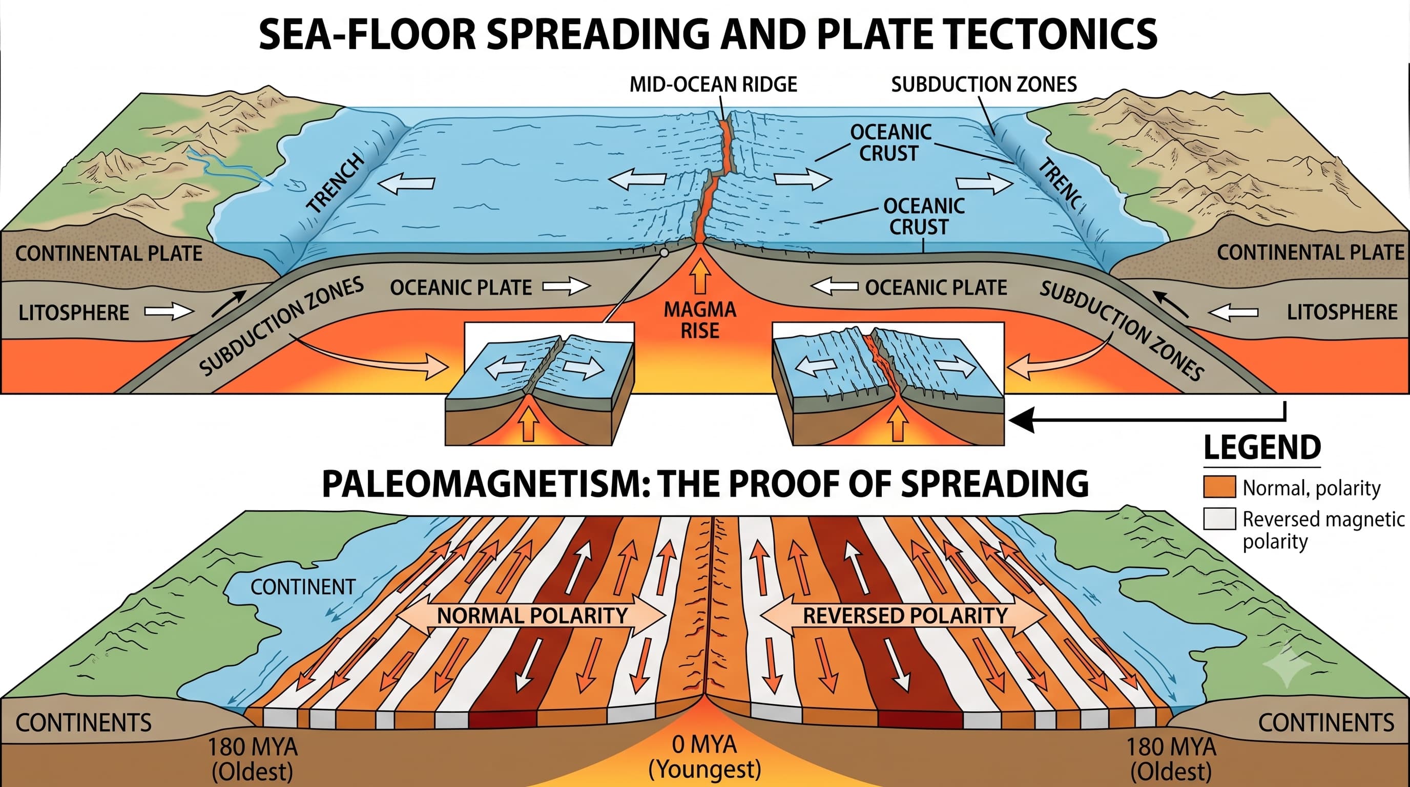
Wegener gave strong evidence that continents had moved, but he could not satisfactorily explain how they moved.
The answer began to emerge after scientists started exploring the ocean floor. They discovered enormous underwater mountain systems, deep trenches, young oceanic rocks and symmetrical magnetic patterns.
1. The Missing Piece after Wegener
Most of Wegener's evidence had come from the continents—matching coastlines, rocks, fossils and ancient glacial deposits.
Very little was known about the deep ocean floor in his time. This changed dramatically after the Second World War.
The new question was:
If continents move apart, what happens to the ocean floor between them?
2. Mapping the Ocean Floor Changed the Debate
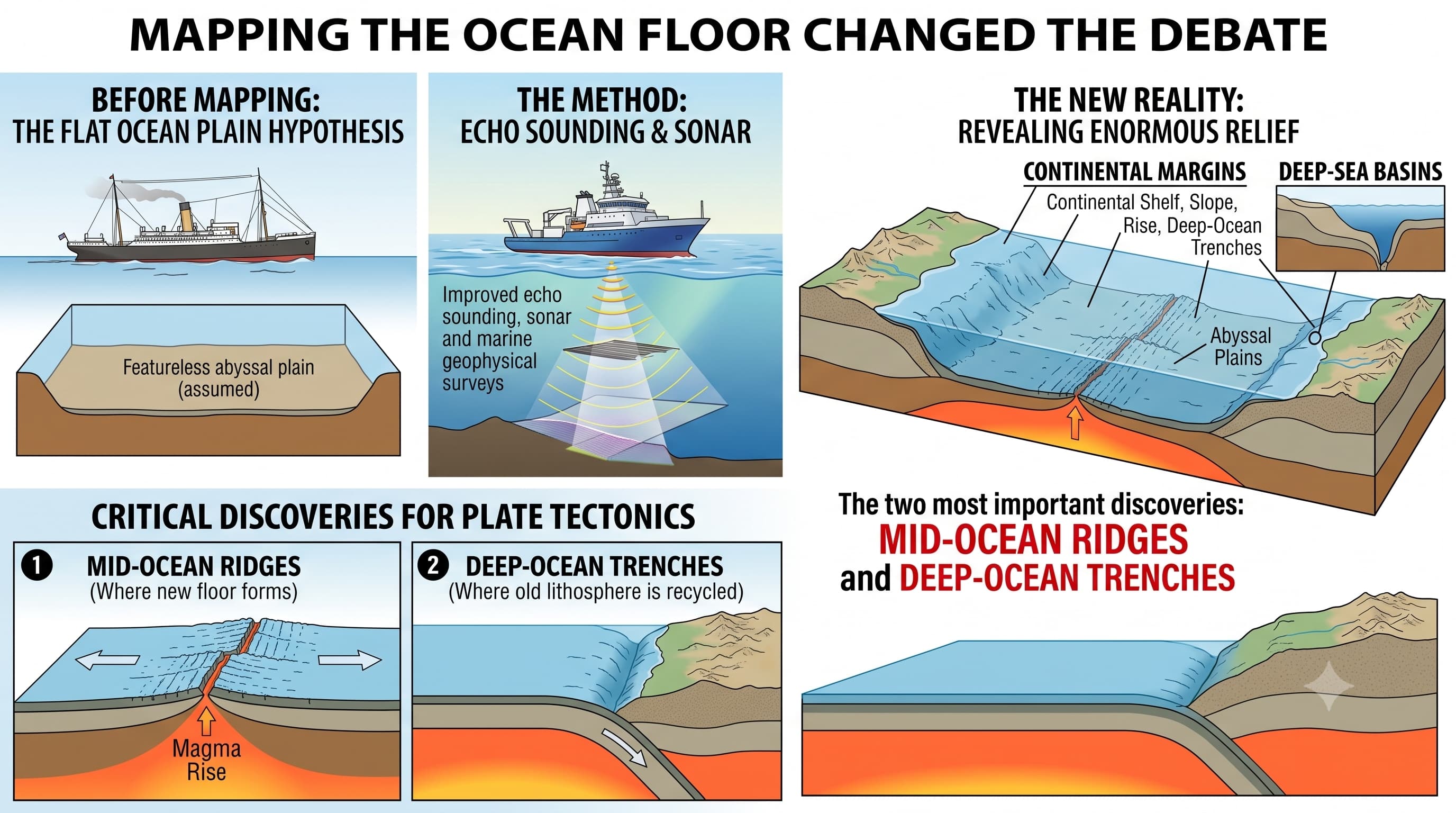
Improved echo sounding, sonar and marine geophysical surveys revealed that the ocean floor is not a flat, featureless plain.
It contains enormous relief features such as:
Continental margins include the continental shelf, slope, rise and deep-ocean trenches. Extensive flat areas between continental margins and mid-ocean ridges are called abyssal plains.
For plate tectonics, the two most important discoveries were the mid-ocean ridges, where new ocean floor forms, and deep-ocean trenches, where old oceanic lithosphere can be recycled into the mantle.
3. Mid-Ocean Ridges: Underwater Mountain Systems
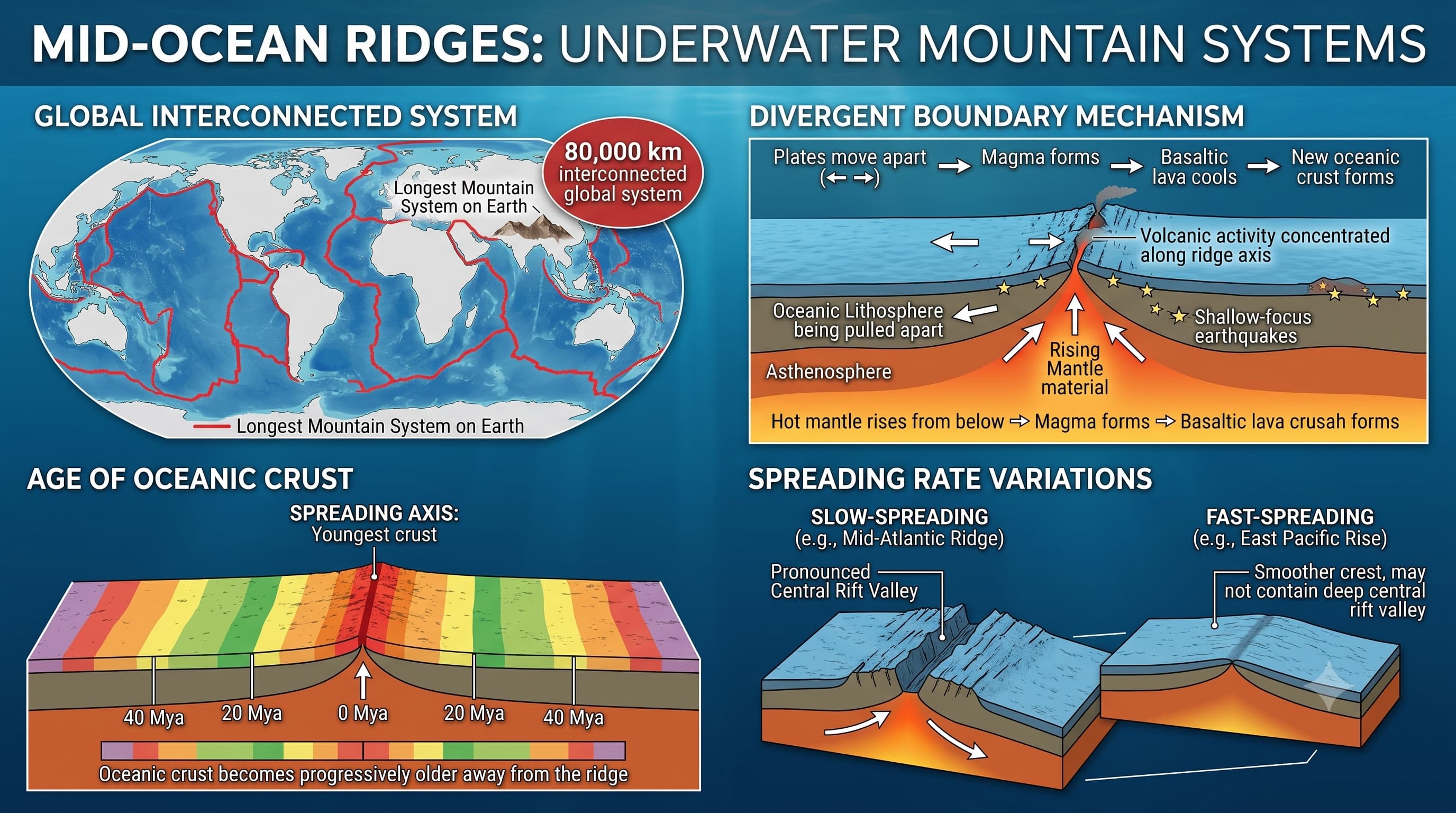
Mid-ocean ridges form an interconnected global system of submarine mountains. Together they constitute the longest mountain system on Earth, although most of it lies beneath ocean water.
They occur where the oceanic lithosphere is being pulled apart and hot mantle material rises from below.
Volcanic activity is concentrated along the ridge axis.
Earthquakes associated with ridges are generally shallow-focus.
The crust at or near the spreading axis is the youngest oceanic crust.
Oceanic crust becomes progressively older away from the ridge.
Many slow-spreading ridges have a pronounced central rift valley. At faster-spreading ridges the ridge crest may be smoother and may not contain a deep central rift valley.
4. Five Ocean-Floor Observations That Needed an Explanation
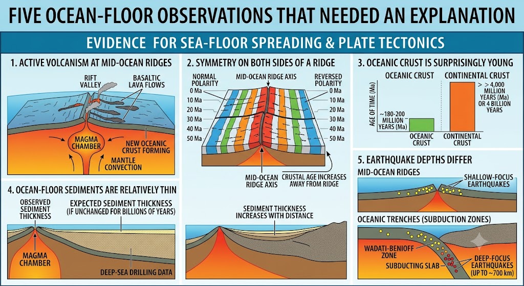
1. Active volcanism at mid-ocean ridges
Large quantities of basaltic material repeatedly reach the ocean floor along ridge systems.
2. Symmetry on both sides of a ridge
Rocks at similar distances on opposite sides of a ridge commonly show comparable age, composition and magnetic characteristics.
3. Oceanic crust is surprisingly young
Present oceanic crust is generally younger than about 180–200 million years, whereas continental rocks can be billions of years old.
4. Ocean-floor sediments are relatively thin
If present ocean basins had remained unchanged for billions of years, far thicker and much older sediment sequences would be expected.
5. Earthquake depths differ
Mid-ocean ridges mainly show shallow earthquakes, while oceanic trenches associated with subduction can show earthquakes extending to much greater depths.
5. Harry Hess and the Sea-Floor Spreading Hypothesis
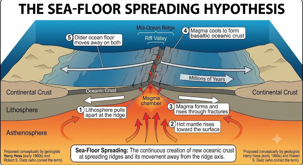
In the early 1960s, American geologist Harry Hess proposed that the ocean floor itself was continually being created and moved sideways.
Geologist Robert S. Dietz independently developed a similar idea and introduced the term “sea-floor spreading.”
6. If New Crust Is Continuously Created, Why Doesn't Earth Grow Larger?
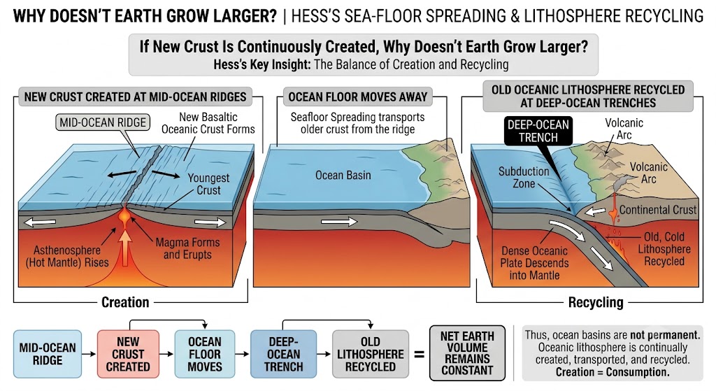
This was an important part of Hess's idea.
New oceanic crust is created at mid-ocean ridges, but old oceanic lithosphere can eventually descend into the mantle at deep-ocean trenches.
New Crust Created
↓
Ocean Floor Moves Away
↓
Deep-Ocean Trench
↓
Old Oceanic Lithosphere Recycled
Thus, ocean basins are not permanent structures. Oceanic lithosphere is continually created, transported and recycled.
We will study the full process of subduction and different types of convergent boundaries later. Here, the important point is simply that old oceanic crust can be consumed at trenches.
7. What is Paleomagnetism?
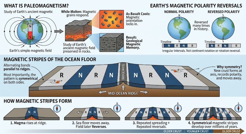
Paleomagnetism is the study of the record of the Earth's ancient magnetic field preserved in rocks.
Basalt forming the ocean floor contains magnetic minerals, especially magnetite.
In this way, volcanic rocks can act like a geological magnetic memory.
8. Normal and Reversed Magnetic Polarity
Earth's magnetic field has reversed many times during geological history.
Normal Polarity
Magnetic orientation is broadly the same as the Earth's present magnetic field.
Reversed Polarity
The magnetic field is oriented opposite to the present polarity.
These reversals occur at irregular intervals. They are not caused by continents physically turning around and they do not mean that Earth's rotation reverses.
9. The Magnetic Stripes of the Ocean Floor
Marine magnetometer surveys discovered alternating bands of normal and reversed magnetic polarity running roughly parallel to mid-ocean ridges.
Most importantly, the pattern on one side of a ridge closely mirrors the pattern on the other side.
N = Normal Polarity | R = Reversed Polarity
Why symmetry? New crust forms along the ridge axis and moves away in opposite directions. Each new band records the magnetic polarity that existed when it cooled.
10. How Magnetic Stripes Form
↓
Basalt cools and records current magnetic polarity
↓
Sea floor moves away from ridge
↓
Earth's magnetic field later reverses
↓
New basalt records the new polarity
↓
Repeated spreading + repeated reversals
↓
Symmetrical magnetic stripes develop on both sides
11. Vine–Matthews–Morley Explanation
In 1963, British geologists Frederick Vine and Drummond Matthews connected sea-floor spreading with repeated reversals of Earth's magnetic field.
Canadian geophysicist Lawrence Morley independently reached essentially the same explanation.
Their explanation showed why magnetic stripes are parallel to the ridge and symmetrical on both sides.
This became one of the strongest pieces of evidence for sea-floor spreading.
12. Age of the Ocean Floor: A Powerful Test
Farther from Ridge = Progressively Older Crust
This age pattern occurs on both sides of active spreading ridges and strongly supports continuous formation of new oceanic crust at the centre.
The oldest preserved oceanic crust in today's ocean basins is only about 180–200 million years old.
Continental crust is very different: it preserves rocks that are several billion years old.
Why the difference?
Oceanic lithosphere is continually produced at ridges and eventually recycled at subduction zones, whereas large parts of continental crust survive for much longer periods.
13. Sediments Provide Another Clue
Newly formed crust near a mid-ocean ridge has had very little time to accumulate sediment.
Farther away → Older crust → More time for sediment accumulation
The generally young age and limited thickness of ocean-floor sediments were therefore exactly what sea-floor spreading predicted.
14. Deep-Sea Drilling Confirmed the Pattern
Later deep-sea drilling allowed scientists to recover actual rock and sediment samples from the ocean floor.
Studies such as those conducted by the research vessel Glomar Challenger confirmed that:
Ocean-floor rocks are youngest near spreading ridges.
Their age increases away from the ridge.
Sediment generally becomes thicker with increasing distance and age.
15. Earthquakes and Volcanoes Also Reveal the Pattern
Earthquakes and volcanoes are not randomly distributed across the Earth.
Mid-Ocean Ridges
Intense submarine volcanism and mainly shallow earthquakes.
Subduction Margins
Strong earthquakes, including deeper earthquakes, together with major volcanic belts.
A major concentration of earthquakes and active volcanoes surrounds the Pacific Ocean—the famous Pacific Ring of Fire.
The Alpine-Himalayan belt is another major global seismic belt, although its tectonic setting differs from the oceanic subduction zones that dominate much of the Pacific margin.
16. Magnetic Stripes Can Measure the Rate of Spreading
Once the ages of magnetic reversals are known, scientists can compare them with the distance of magnetic stripes from the ridge.
This allows scientists to reconstruct how quickly different ocean basins have opened through geological time.
Different spreading centres move at different rates; some spread only a few centimetres per year, while fast-spreading systems such as parts of the East Pacific Rise spread much faster.
17. Why Sea-Floor Spreading Was So Convincing
18. From Wegener to Hess: What Changed?
Wegener
Correctly recognised that continents had moved.
Had strong continental evidence.
Could not provide a satisfactory mechanism.
Hess & Ocean-Floor Studies
Showed that the ocean floor itself is mobile.
New crust forms at oceanic ridges.
Old oceanic lithosphere is eventually recycled.
Sea-Floor Spreading: The ocean floor moves too.
Plate Tectonics: Entire lithospheric plates move.
19. Common Confusions to Avoid
No. “Mid-ocean ridge” is a geological term for an oceanic spreading ridge; its position need not be geometrically central in the ocean basin.
No. The oceanic lithosphere itself is created, moves and is recycled.
No. They are differences in magnetic signature detected using instruments such as magnetometers.
No. It refers only to reversal of the Earth's magnetic-field polarity.
No. Present oceanic crust is continually recycled and is mostly much younger.
Quick Revision
Post-war ocean-floor mapping revealed ridges, abyssal plains and deep trenches.
Mid-ocean ridges form the world's longest interconnected submarine mountain system.
New oceanic crust forms at spreading ridges.
Harry Hess developed the sea-floor spreading hypothesis in the early 1960s.
Robert Dietz independently advanced the idea and coined the term “sea-floor spreading”.
Oceanic crust is youngest at the ridge and becomes older away from it.
Present oceanic crust is generally no older than about 180–200 million years.
Paleomagnetism studies the ancient magnetic field recorded in rocks.
Magnetic minerals in cooling basalt preserve the direction of Earth's magnetic field.
Earth's field has repeatedly switched between normal and reversed polarity.
Symmetrical magnetic stripes on both sides of ridges provide powerful evidence for sea-floor spreading.
Vine–Matthews–Morley linked magnetic reversals with sea-floor spreading.
Ocean-floor sediments are relatively thin and generally become thicker away from spreading centres.
Old oceanic lithosphere is eventually recycled at subduction zones/trenches.
Magnetic stripes can also be used to calculate the rate of sea-floor spreading.
Think Like UPSC
Suppose samples are collected at increasing distances from an active mid-ocean ridge. What broad pattern should you expect?
If matching magnetic bands occur at equal distances on opposite sides of the ridge, they strongly indicate roughly symmetrical creation and outward movement of ocean floor.
सागर-तल प्रसरण, मध्य-महासागरीय कटक और पुराचुंबकत्व
वेगेनर ने इस बात के मजबूत प्रमाण दिए कि महाद्वीप खिसके हैं, लेकिन वे संतोषजनक रूप से यह नहीं समझा सके कि वे कैसे खिसके.
इसका उत्तर तब सामने आने लगा जब वैज्ञानिकों ने महासागरीय तलका अध्ययन शुरू किया। उन्होंने समुद्र के भीतर विशाल पर्वत प्रणालियाँ, गहरी खाइयाँ, युवा महासागरीय चट्टानें और सममित चुंबकीय प्रतिरूप खोजे।
1. वेगेनर के बाद बची हुई कड़ी
वेगेनर के अधिकांश प्रमाण महाद्वीपोंसे आए थे—मेल खाते तटरेखाएँ, चट्टानें, जीवाश्म और प्राचीन हिमानी निक्षेप।
उनके समय में गहरे महासागरीय तल के बारे में बहुत कम जानकारी थी। द्वितीय विश्व युद्ध के बाद यह स्थिति नाटकीय रूप से बदल गई।
नया प्रश्न था:
यदि महाद्वीप एक-दूसरे से दूर जाते हैं, तो उनके बीच के महासागरीय तल का क्या होता है?
2. महासागरीय तल के मानचित्रण ने बहस को बदल दिया
बेहतर इको साउंडिंग, सोनार और समुद्री भूभौतिकीय सर्वेक्षणों ने दिखाया कि महासागरीय तल कोई समतल और विशेषतारहित मैदान नहीं है।
इसमें विशाल उच्चावच स्थलरूप पाए जाते हैं, जैसे:
महाद्वीपीय किनारों में महाद्वीपीय शेल्फ, ढाल, उत्थान और गहरी महासागरीय खाइयाँशामिल होती हैं। महाद्वीपीय किनारों और मध्य-महासागरीय कटकों के बीच के विस्तृत समतल क्षेत्रों को अथाह मैदान.
प्लेट विवर्तनिकी के लिए दो सबसे महत्वपूर्ण खोजें थीं मध्य-महासागरीय कटक, जहाँ नया महासागरीय तल बनता है, और गहरी महासागरीय खाइयाँ, जहाँ पुराना महासागरीय स्थलमंडल पुनः मेंटल में समाहित हो सकता है।
3. मध्य-महासागरीय कटक: समुद्र के भीतर पर्वत प्रणालियाँ
मध्य-महासागरीय कटक समुद्र के भीतर स्थित पर्वतों की परस्पर जुड़ी वैश्विक प्रणाली बनाते हैं। मिलकर ये पृथ्वी की सबसे लंबी पर्वत प्रणालीबनाते हैं, यद्यपि इसका अधिकांश भाग महासागरीय जल के नीचे स्थित है।
ये वहाँ पाए जाते हैं जहाँ महासागरीय स्थलमंडल अलग खिंच रहा होता है और नीचे से गर्म मेंटल पदार्थ ऊपर उठता है।
ज्वालामुखीय गतिविधि कटक अक्ष के साथ केंद्रित होती है।
कटकों से जुड़े भूकंप सामान्यतः उथले केंद्र वाले होते हैं.
प्रसरण अक्ष पर या उसके पास की भूपर्पटी सबसे युवा महासागरीय भूपर्पटी होती है.
कटक से दूर जाने पर महासागरीय भूपर्पटी क्रमशः पुरानी होती जाती है।
कई धीमी गति से फैलने वाले कटकों में स्पष्ट केंद्रीय रिफ्ट घाटीहोती है। तेज गति से फैलने वाले कटकों में कटक शिखर अधिक समतल हो सकता है और वहाँ गहरी केंद्रीय भ्रंश घाटी नहीं भी हो सकती।
4. महासागरीय तल से जुड़ी पाँच बातें जिनकी व्याख्या आवश्यक थी
1. मध्य-महासागरीय कटकों पर सक्रिय ज्वालामुखिता
कटक प्रणालियों के साथ बड़ी मात्रा में बेसाल्टी पदार्थ बार-बार महासागरीय तल तक पहुँचता है।
2. कटक के दोनों ओर सममिति
कटक के विपरीत पक्षों पर समान दूरी पर स्थित चट्टानों में प्रायः समान आयु, संरचना और चुंबकीय विशेषताएँ पाई जाती हैं.
3. महासागरीय भूपर्पटी आश्चर्यजनक रूप से युवा है
वर्तमान महासागरीय भूपर्पटी सामान्यतः लगभग 18–20 करोड़ वर्षसे कम पुरानी है, जबकि महाद्वीपीय चट्टानें अरबों वर्ष पुरानी हो सकती हैं।
4. महासागरीय तल के अवसाद अपेक्षाकृत पतले हैं
यदि वर्तमान महासागरीय बेसिन अरबों वर्षों तक अपरिवर्तित रहे होते, तो कहीं अधिक मोटे और बहुत पुराने अवसादी क्रम मिलने चाहिए थे।
5. भूकंपों की गहराई अलग-अलग होती है
मध्य-महासागरीय कटकों पर मुख्यतः उथले भूकंप आते हैं, जबकि अधोगमन से जुड़ी महासागरीय खाइयों में भूकंप बहुत अधिक गहराई तक पाए जा सकते हैं।
5. हैरी हेस और सागर-तल प्रसरण परिकल्पना
आरंभिक 1960 के दशकमें अमेरिकी भूवैज्ञानिक हैरी हेस ने प्रस्तावित किया कि महासागरीय तल स्वयं लगातार बनता है और पार्श्व दिशा में खिसकता है।
भूवैज्ञानिक रॉबर्ट एस. डिट्ज़ ने स्वतंत्र रूप से इसी प्रकार का विचार विकसित किया और इस विचार के लिए “सागर-तल प्रसरण” शब्द प्रस्तुत किया।
6. यदि नई भूपर्पटी लगातार बन रही है, तो पृथ्वी का आकार बड़ा क्यों नहीं होता?
यह हेस के विचार का एक महत्वपूर्ण भाग था।
नई महासागरीय भूपर्पटी मध्य-महासागरीय कटकों पर बनती है, लेकिन पुराना महासागरीय स्थलमंडल अंततः मेंटल में नीचे जा सकता है, विशेषकर गहरी महासागरीय खाइयों पर।
नई भूपर्पटी का निर्माण
↓
महासागरीय तल दूर खिसकता है
↓
गहरी महासागरीय खाई
↓
पुराने महासागरीय स्थलमंडल का पुनर्चक्रण
इस प्रकार महासागरीय बेसिन स्थायी संरचनाएँ नहीं हैं। महासागरीय स्थलमंडल लगातार बनता, स्थानांतरित होता और पुनर्चक्रित होता है.
हम आगे अधोगमन की पूरी प्रक्रिया और विभिन्न प्रकार की अभिसारी सीमाओं का अध्ययन करेंगे। यहाँ महत्वपूर्ण बात केवल इतनी है कि पुरानी महासागरीय भूपर्पटी खाइयों पर समाप्त हो सकती है।
7. पुराचुंबकत्व क्या है?
पुराचुंबकत्व चट्टानों में संरक्षित पृथ्वी के प्राचीन चुंबकीय क्षेत्र के अभिलेख का अध्ययन है।
महासागरीय तल बनाने वाले बेसाल्ट में चुंबकीय खनिज पाए जाते हैं, विशेषकर मैग्नेटाइट.
इस प्रकार ज्वालामुखीय चट्टानें भूवैज्ञानिक चुंबकीय स्मृति की तरह काम कर सकती हैं.
8. सामान्य और विपरीत चुंबकीय ध्रुवता
पृथ्वी का चुंबकीय क्षेत्र भूवैज्ञानिक इतिहास में कई बार उलट चुका है ।
सामान्य ध्रुवता
चुंबकीय अभिविन्यास मोटे तौर पर पृथ्वी के वर्तमान चुंबकीय क्षेत्र जैसा होता है।
विपरीत ध्रुवता
चुंबकीय क्षेत्र वर्तमान ध्रुवता के विपरीत दिशा में उन्मुख होता है।
ये उलटाव अनियमित अंतरालोंपर होते हैं। इनका अर्थ यह नहीं है कि महाद्वीप भौतिक रूप से पलट जाते हैं या पृथ्वी का घूर्णन उलट जाता है।
9. महासागरीय तल की चुंबकीय पट्टियाँ
समुद्री मैग्नेटोमीटर सर्वेक्षणों में सामान्य और विपरीत चुंबकीय ध्रुवता की वैकल्पिक पट्टियाँ मिलीं, जो लगभग मध्य-महासागरीय कटकों के समानांतर चलती हैं।
सबसे महत्वपूर्ण बात यह है कि कटक के एक ओर का प्रतिरूप दूसरी ओर के प्रतिरूप का लगभग दर्पण प्रतिबिंब होता है।
N = सामान्य ध्रुवता | R = विपरीत ध्रुवता
सममिति क्यों? नई भूपर्पटी कटक अक्ष के साथ बनती है और विपरीत दिशाओं में दूर जाती है। प्रत्येक नई पट्टी उस समय की चुंबकीय ध्रुवता दर्ज करती है जब वह ठंडी हुई थी।
10. चुंबकीय पट्टियाँ कैसे बनती हैं
↓
बेसाल्ट ठंडा होकर वर्तमान चुंबकीय ध्रुवता दर्ज करता है
↓
महासागरीय तल कटक से दूर खिसकता है
↓
बाद में पृथ्वी का चुंबकीय क्षेत्र उलट जाता है
↓
नया बेसाल्ट नई ध्रुवता दर्ज करता है
↓
बार-बार प्रसरण + बार-बार चुंबकीय उलटाव
↓
दोनों ओर सममित चुंबकीय पट्टियाँ विकसित होती हैं
11. वाइन–मैथ्यूज़–मॉर्ले व्याख्या
1963में ब्रिटिश भूवैज्ञानिक फ्रेडरिक वाइन और ड्रमंड मैथ्यूज़ ने सागर-तल प्रसरण को पृथ्वी के चुंबकीय क्षेत्र के बार-बार होने वाले उलटावों से जोड़ा।
कनाडाई भूभौतिकविद् लॉरेंस मॉर्ले ने स्वतंत्र रूप से लगभग यही व्याख्या प्रस्तुत की।
उनकी व्याख्या ने बताया कि चुंबकीय पट्टियाँ कटक के समानांतर और दोनों ओर सममित क्यों होती हैं.
यह सागर-तल प्रसरण के सबसे मजबूत प्रमाणों में से एक बन गया।
12. महासागरीय तल की आयु: एक शक्तिशाली परीक्षण
कटक से दूर = क्रमशः पुरानी भूपर्पटी
यह आयु प्रतिरूप सक्रिय प्रसरण कटकों के दोनों ओर मिलता है और केंद्र पर नई महासागरीय भूपर्पटी के निरंतर निर्माण का मजबूत समर्थन करता है।
आज के महासागरीय बेसिनों में संरक्षित सबसे पुरानी महासागरीय भूपर्पटी केवल लगभग 18–20 करोड़ वर्ष पुरानी होती है.
महाद्वीपीय भूपर्पटी बिल्कुल अलग है: इसमें कई अरब वर्ष पुरानी चट्टानें सुरक्षित हैं.
चट्टानें सुरक्षित हैं। अंतर क्यों?
महासागरीय स्थलमंडल कटकों पर लगातार बनता है और अंततः अधोगमन क्षेत्रों में पुनर्चक्रित हो जाता है, जबकि महाद्वीपीय भूपर्पटी के बड़े हिस्से बहुत लंबे समय तक बने रहते हैं।
13. अवसाद एक और संकेत देते हैं
मध्य-महासागरीय कटक के पास नई बनी भूपर्पटी को अवसाद जमा करने के लिए बहुत कम समय मिला होता है।
दूर जाने पर → पुरानी भूपर्पटी → अवसाद जमा होने के लिए अधिक समय
इसलिए महासागरीय तल के अवसादों की सामान्यतः कम आयु और सीमित मोटाई ठीक वही थी जिसकी भविष्यवाणी सागर-तल प्रसरण ने की थी।
14. गहरे समुद्र की ड्रिलिंग ने प्रतिरूप की पुष्टि की
बाद में गहरे समुद्र की ड्रिलिंग से वैज्ञानिक महासागरीय तल से वास्तविक चट्टान और अवसाद के नमूने प्राप्त कर सके।
अनुसंधान पोत ग्लोमर चैलेंजर द्वारा किए गए अध्ययनों सहित कई अध्ययनों ने पुष्टि की कि:
महासागरीय तल की चट्टानें प्रसरण कटकों के पास सबसे युवा होती हैं।
कटक से दूर जाने पर उनकी आयु बढ़ती जाती है।
दूरी और आयु बढ़ने के साथ अवसाद सामान्यतः मोटा होता जाता है।
15. भूकंप और ज्वालामुखी भी प्रतिरूप दिखाते हैं
भूकंप और ज्वालामुखी पृथ्वी पर यादृच्छिक रूप से वितरित नहीं हैं।
मध्य-महासागरीय कटक
तीव्र समुद्री ज्वालामुखिता और मुख्यतः उथले भूकंप।
अधोगमन सीमाएँ
शक्तिशाली भूकंप, जिनमें गहरे भूकंप भी शामिल हैं, तथा प्रमुख ज्वालामुखीय पट्टियाँ।
भूकंपों और सक्रिय ज्वालामुखियों का एक प्रमुख संकेंद्रण प्रशांत महासागर के चारों ओर पाया जाता है—प्रसिद्ध प्रशांत अग्निवलय.
आल्प्स-हिमालयी पट्टी एक अन्य प्रमुख वैश्विक भूकंपीय पट्टी है, यद्यपि इसकी विवर्तनिक स्थिति उन महासागरीय अधोगमन क्षेत्रों से भिन्न है जो प्रशांत किनारे के बड़े भाग पर प्रमुख हैं।
16. चुंबकीय पट्टियाँ प्रसरण की दर माप सकती हैं
एक बार चुंबकीय उलटावों की आयु ज्ञात हो जाने पर, वैज्ञानिक उनकी तुलना कटक से चुंबकीय पट्टियों की दूरी से कर सकते हैं।
इससे वैज्ञानिक पुनर्निर्माण कर सकते हैं कि भूवैज्ञानिक समय में अलग-अलग महासागरीय बेसिन कितनी तेजी से खुले।
अलग-अलग प्रसरण केंद्र अलग-अलग दरों से फैलते हैं; कुछ केवल कुछ सेंटीमीटर प्रति वर्ष फैलते हैं, जबकि ईस्ट पैसिफिक राइज़ के कुछ भागों जैसी तेज-प्रसरण प्रणालियाँ कहीं अधिक तेजी से फैलती हैं।
17. सागर-तल प्रसरण इतना विश्वसनीय क्यों था
18. वेगेनर से हेस तक: क्या बदला?
वेगेनर
उन्होंने सही पहचाना कि महाद्वीप खिसके हैं।
उनके पास महाद्वीपीय प्रमाण मजबूत थे।
वे संतोषजनक क्रियाविधि नहीं बता सके।
हेस और महासागरीय तल के अध्ययन
दिखाया कि महासागरीय तल स्वयं गतिशील है।
महासागरीय कटकों पर नई भूपर्पटी बनती है।
पुराना महासागरीय स्थलमंडल अंततः पुनर्चक्रित होता है।
सागर-तल प्रसरण: महासागरीय तल भी खिसकता है।
प्लेट विवर्तनिकी: पूरी स्थलमंडलीय प्लेटें गतिशील होती हैं।
19. सामान्य भ्रम जिनसे बचें
नहीं। “मध्य-महासागरीय कटक” महासागरीय प्रसरण कटक के लिए भूवैज्ञानिक शब्द है; इसका महासागरीय बेसिन के ज्यामितीय केंद्र में होना आवश्यक नहीं है।
नहीं। महासागरीय स्थलमंडल स्वयं बनता है, चलता है और पुनर्चक्रित होता है।
नहीं। वे चुंबकीय संकेतों में अंतर हैं, जिन्हें मैग्नेटोमीटर जैसे उपकरणों से मापा जाता है।
नहीं। इसका अर्थ केवल पृथ्वी के चुंबकीय क्षेत्र की ध्रुवता का उलटना है।
नहीं। वर्तमान महासागरीय भूपर्पटी लगातार पुनर्चक्रित होती रहती है और अधिकांशतः बहुत युवा है।
त्वरित पुनरावृत्ति
युद्धोत्तर महासागरीय तल के मानचित्रण से कटक, अथाह मैदान और गहरी खाइयों का पता चला.
मध्य-महासागरीय कटक दुनिया की सबसे लंबी परस्पर जुड़ी समुद्री पर्वत प्रणाली बनाते हैं।
प्रसरण कटकों पर नई महासागरीय भूपर्पटी बनती है।
हैरी हेस ने सागर-तल प्रसरण परिकल्पना को 1960 के दशक के आरंभ में विकसित किया.
रॉबर्ट डिट्ज़ ने स्वतंत्र रूप से इस विचार को आगे बढ़ाया और “सागर-तल प्रसरण” शब्द दिया।
महासागरीय भूपर्पटी कटक पर सबसे युवा होती है और उससे दूर जाने पर पुरानी होती जाती है।
वर्तमान महासागरीय भूपर्पटी सामान्यतः लगभग 18–20 करोड़ वर्ष से अधिक पुरानी नहीं है।
पुराचुंबकत्व चट्टानों में दर्ज प्राचीन चुंबकीय क्षेत्र का अध्ययन करता है।
ठंडे होते बेसाल्ट के चुंबकीय खनिज पृथ्वी के चुंबकीय क्षेत्र की दिशा सुरक्षित रखते हैं।
पृथ्वी का चुंबकीय क्षेत्र बार-बार सामान्य और विपरीत ध्रुवता के बीच बदलता रहा है.
कटकों के दोनों ओर सममित चुंबकीय पट्टियाँ सागर-तल प्रसरण का शक्तिशाली प्रमाण हैं।
वाइन–मैथ्यूज़–मॉर्ले ने चुंबकीय उलटावों को सागर-तल प्रसरण से जोड़ा।
महासागरीय तल के अवसाद अपेक्षाकृत पतले होते हैं और सामान्यतः प्रसरण केंद्रों से दूर जाने पर मोटे होते जाते हैं।
पुराना महासागरीय स्थलमंडल अंततः अधोगमन क्षेत्रों/खाइयों में पुनर्चक्रित हो जाता है.
में पुनर्चक्रित हो जाता है। चुंबकीय पट्टियों का उपयोग सागर-तल प्रसरण की दर की गणना करने के लिए भी किया जा सकता है.
UPSC की तरह सोचें
मान लें कि किसी सक्रिय मध्य-महासागरीय कटक से बढ़ती दूरी पर नमूने एकत्र किए जाते हैं। आपको व्यापक रूप से कौन-सा प्रतिरूप मिलने की अपेक्षा होगी?
यदि कटक के विपरीत पक्षों पर समान दूरी पर मेल खाती चुंबकीय पट्टियाँ मिलें, तो वे स्पष्ट रूप से महासागरीय तल के लगभग सममित निर्माण और बाहर की ओर गति का संकेत देती हैं.