Continental Drift Theory: Wegener, Pangaea, Evidence and Limitations
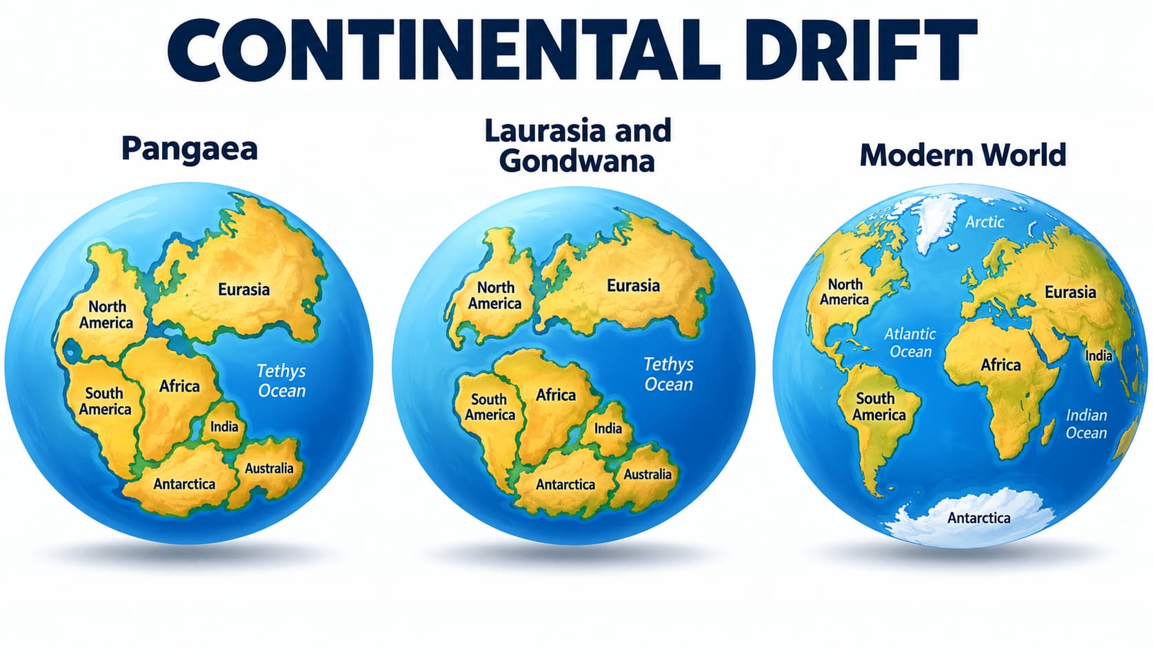
Continents and oceans have not always occupied their present positions. Over geological time, continental masses have repeatedly joined, separated and moved across the Earth's surface.
The first comprehensive scientific attempt to explain this movement was the Continental Drift Theory proposed by Alfred Wegener in 1912.
1. The Question That Started the Debate
Look carefully at the Atlantic Ocean on a world map. The eastern coast of South America and the western coast of Africa appear as if they could fit together.
This simple observation eventually changed our understanding of the Earth from a static planet to a dynamic planet.
2. The Idea Before Wegener
Abraham Ortelius — 1596
The Dutch map-maker suggested that Europe, Africa and the Americas might once have been joined.
Antonio Snider-Pellegrini
In the nineteenth century, he drew maps showing the American and African-European landmasses before and after separation.
However, these were mainly observations. Alfred Wegener was the scientist who brought together geological, fossil and climatic evidence into a systematic theory.
3. Alfred Wegener and Continental Drift
Alfred Lothar Wegener was a German meteorologist and polar researcher.
In 1912, he presented the theory of continental drift. He later developed it in his book The Origin of Continents and Oceans, first published in 1915.
Wegener's central idea was simple: continents are not permanently fixed; they have changed their positions through geological time.
4. Pangaea and Panthalassa
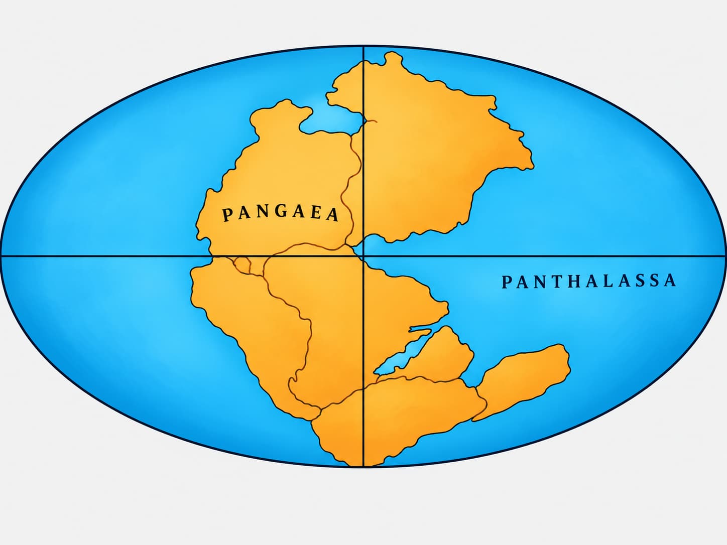
Wegener proposed that the present continents were once united into a single huge continental mass.
The giant supercontinent
“All Earth”
The enormous surrounding ocean
“All Water”
Wegener argued that Pangaea began to break apart roughly 200 million years ago.
5. Laurasia, Gondwanaland and Tethys
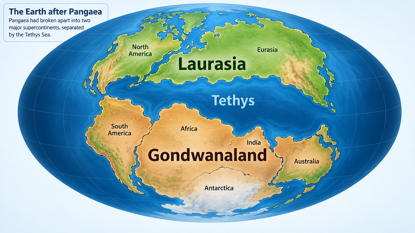
In the simplified reconstruction used in physical geography, Pangaea separated into two major continental groups.
Laurasia — North
Included the major northern continental masses that later contributed to North America, Europe and much of Asia.
Gondwanaland — South
Included South America, Africa, India, Madagascar, Australia and Antarctica.
Tethys: Tethyan waters occupied the broad region between the northern and southern continental masses. Its later history becomes very important when we study the formation of the Alpine-Himalayan mountain system.
6. The Continental Drift Story in One Flow

↓
Laurasia + Gondwanaland
↓
Further fragmentation
↓
Continental masses move apart
↓
Present-day distribution of continents develops
7. Evidence for Continental Drift
Wegener did not rely on only the shape of continents. He combined evidence from maps, rocks, fossils, glacial deposits and ancient climates.
8. Evidence 1: Jig-Saw Fit of the Continents
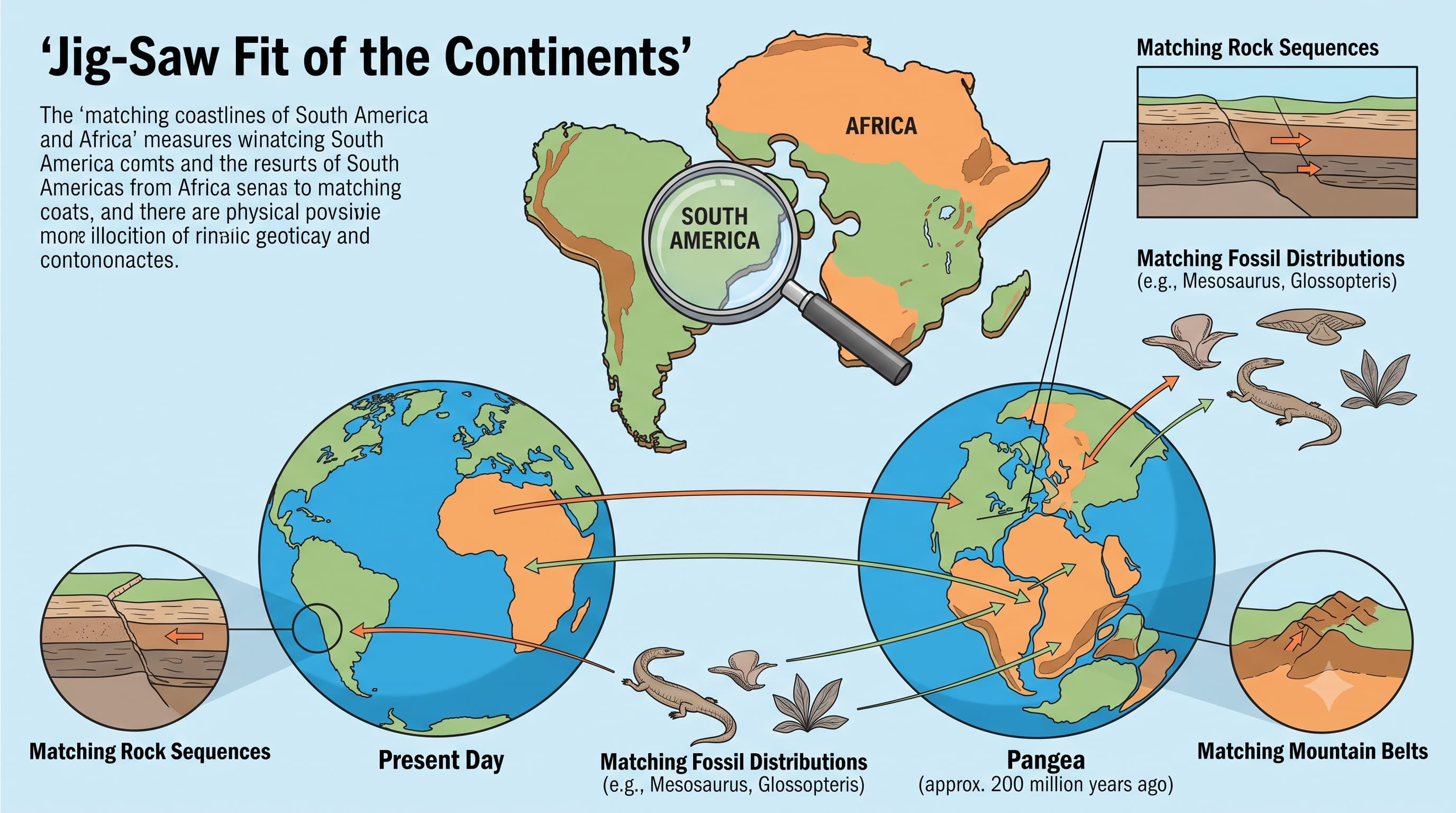
The most obvious example is the remarkable fit between the eastern margin of South America and the western margin of Africa.
Modern shorelines are affected by erosion, deposition and sea-level change, so they do not fit perfectly.
In 1964, Sir Edward Bullard and colleagues produced a much better computer-assisted fit of the Atlantic margins using approximately the 1,000-fathom line rather than the present coastline.
This is why the real evidence is better described as the matching of continental margins, not simply matching today's beach lines.
9. Evidence 2: Matching Rocks and Geological History
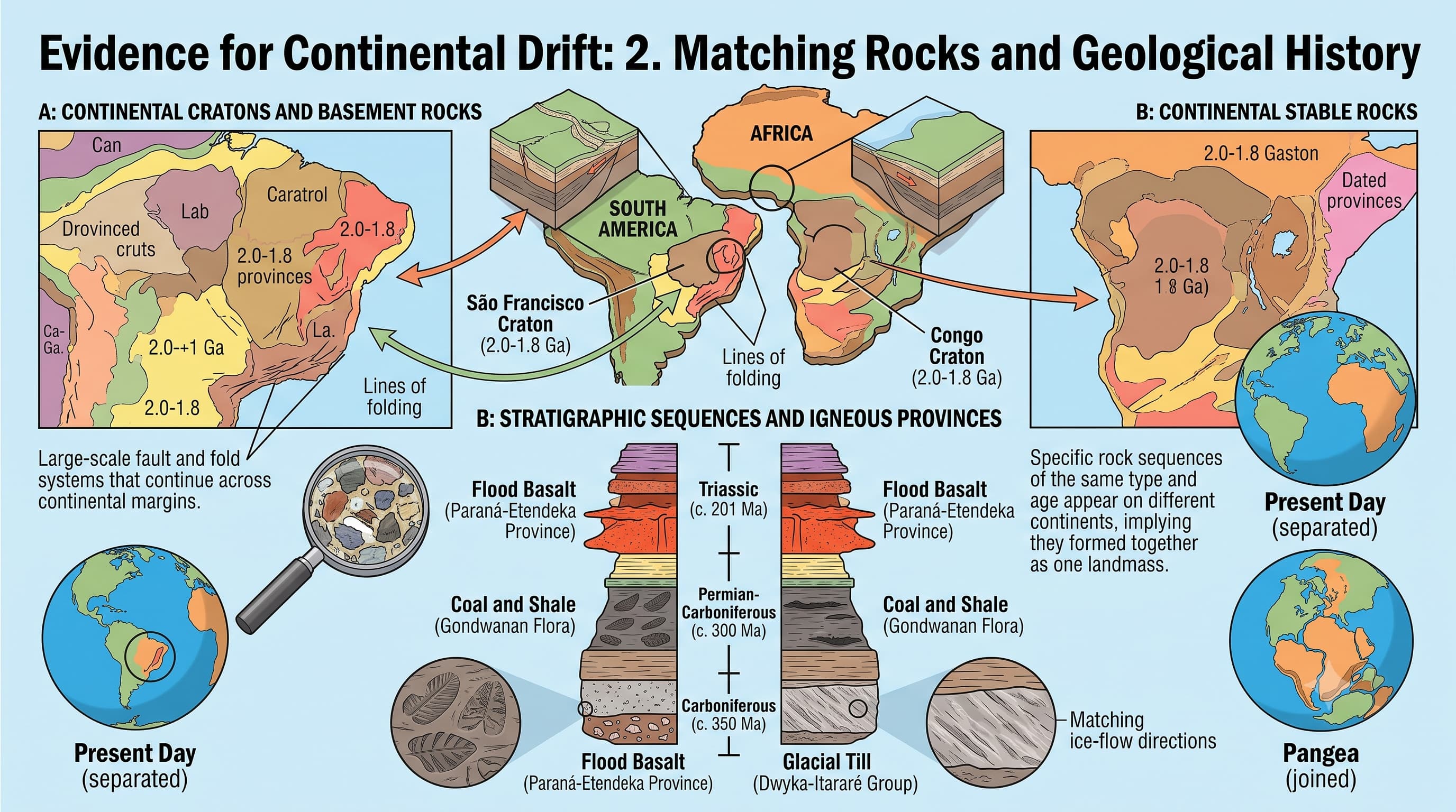
Rock formations on continents now separated by oceans often match in age, composition and geological history.
Ancient rocks approximately 2,000 million years old along the Brazilian coast correspond with rocks in western Africa.
The earliest marine deposits along parts of the South American and African Atlantic margins are of Jurassic age, indicating that the South Atlantic opened later in geological history.
If two continents were once connected, rock belts that were originally continuous should match when the continents are reconstructed—and many of them do.
10. Evidence 3: Tillite and Ancient Glaciation
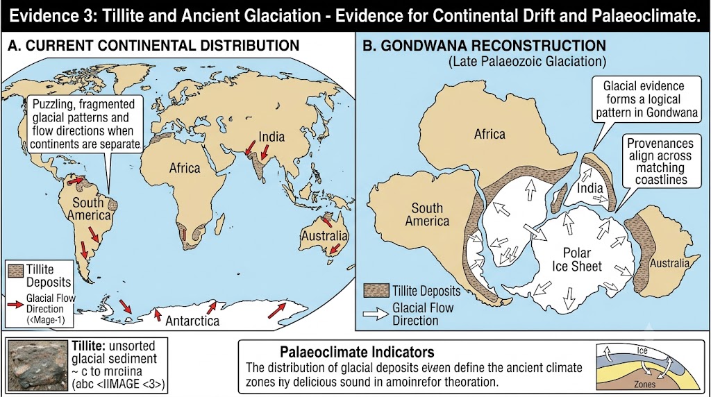
Tillite is a sedimentary rock formed from deposits left by ancient glaciers.
Gondwana rock sequences in India contain evidence of extensive ancient glaciation. Similar glacial deposits occur in:
When these southern continents are placed together, the glacial evidence forms a much more logical geographical pattern.
Tillite is therefore evidence not only of continental drift but also of palaeoclimate—the climate of the geological past.
11. Evidence 4: Placer Gold Deposits
Rich placer gold deposits occur along the coast of Ghana in West Africa, even though suitable source rocks are absent nearby.
Corresponding gold-bearing rocks occur in the Brazilian region across the Atlantic.
12. Evidence 5: Distribution of Fossils
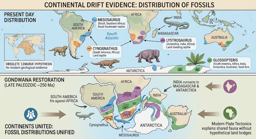
Identical fossils of land or freshwater organisms occur on continents now separated by wide oceans. Such organisms could not easily have crossed a vast ocean.
Mesosaurus
A small freshwater/brackish-water reptile whose fossils occur in southern Africa and Brazil, now separated by the South Atlantic.
Glossopteris
Fossils of this seed fern occur across several former Gondwana continents, including India, Africa, South America, Australia and Antarctica.
Lystrosaurus
A land-dwelling reptile whose fossil distribution links parts of Africa, India and Antarctica.
Cynognathus
A land reptile whose fossil remains help connect South America and Africa.
Historical observations of similar animal distributions in India, Madagascar and Africa also led earlier scientists to propose hypothetical land connections such as “Lemuria”. Modern plate tectonics explains these relationships without requiring such a vanished recent land bridge.
13. Evidence 6: Palaeoclimatic Evidence
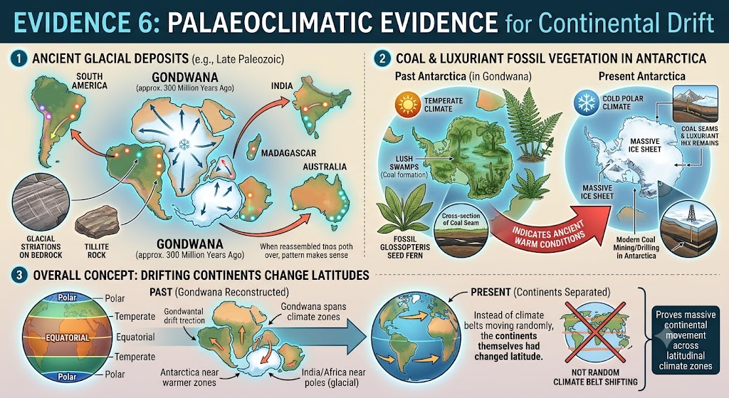
Some rocks and fossils indicate climates very different from the present climate of the same region.
Evidence of ancient glaciers occurs in regions that are now relatively warm.
Coal and fossil remains of luxuriant vegetation occur in Antarctica, indicating that the continent once experienced much warmer conditions.
The wide Gondwana distribution of Glossopteris also supports a very different past arrangement of continents and climatic zones.
14. Evidence at a Glance
15. What Force Did Wegener Think Moved the Continents?
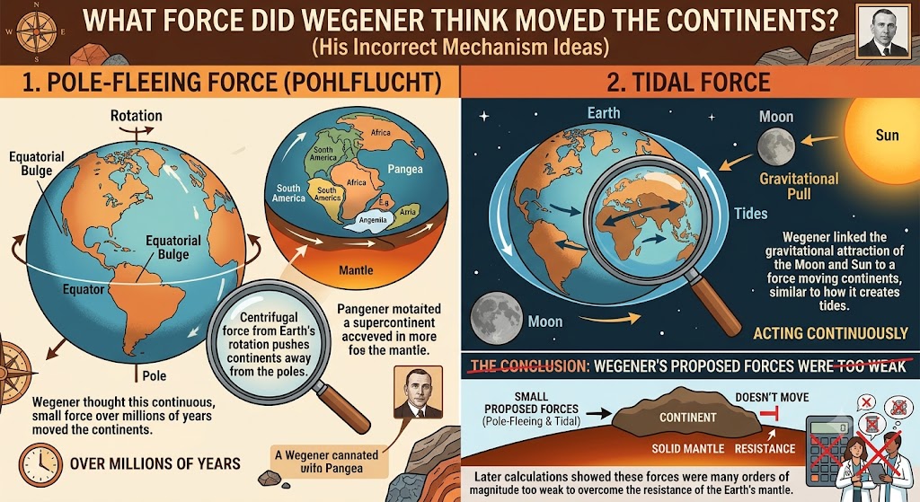
Wegener correctly argued that continents had moved, but he did not know the actual mechanism. He proposed two forces:
Pole-Fleeing Force
Wegener related this force to the rotation of the Earth and its equatorial bulge.
Tidal Force
He linked it to the gravitational attraction of the Moon and the Sun, which also produces tides.
Wegener believed that very small forces acting continuously for millions of years might move continents.
Later calculations showed that these forces were far too weak to move continental masses.
16. Why Was Wegener's Theory Rejected?
Wegener presented impressive evidence that continents had moved, but his explanation had a major weakness:
Pole-fleeing and tidal forces were inadequate.
There was no convincing physical mechanism capable of moving enormous continental masses.
Wegener's model effectively required continents to move through or across resistant oceanic material, which created serious mechanical difficulties.
At that time, scientists had very little information about the structure, age and relief of the ocean floor.
As a result, continental drift remained controversial and was rejected by much of the geological community during Wegener's lifetime.
17. What Wegener Got Right — and What He Got Wrong
Essentially Correct
Continents have changed position.
Present continents were once joined differently.
Pangaea existed as a supercontinent.
Fossil, rock and climatic evidence records past continental connections.
Incorrect / Incomplete
His proposed driving forces were inadequate.
He did not know the true behaviour of the ocean floor.
Continents do not independently plough through oceanic crust.
Modern theory shows that entire lithospheric plates move.
18. Arthur Holmes: An Important Bridge
In the 1930s, British geologist Arthur Holmes suggested that slow convection currents in the mantle could provide a mechanism for large-scale movement.
He related these currents to thermal differences within the mantle, including heat produced by radioactive decay.
19. Important Conceptual Clarifications
No. Modern geology shows that continental masses had moved and assembled into different configurations even before Pangaea.
No. Coastlines change. The continental margins provide a better geological fit.
No. Continental drift established the idea of mobility; plate tectonics later supplied a much broader mechanism involving entire lithospheric plates.
No. His evidence and central insight transformed Earth science and became an essential foundation for modern plate tectonics.
20. Why Continental Drift Was a Turning Point
Before Wegener, continents and ocean basins were widely treated as essentially permanent features.
Continental drift introduced a radically different idea:
This idea eventually became the starting point for explaining the formation of oceans, mountains, trenches, island arcs, earthquakes and volcanoes.
Quick Revision
Abraham Ortelius (1596) was among the earliest to suggest that continents may once have been joined.
Alfred Wegener proposed Continental Drift Theory in 1912.
Wegener's book The Origin of Continents and Oceans appeared in 1915.
Pangaea = supercontinent; Panthalassa = surrounding mega-ocean.
Pangaea began breaking apart roughly 200 million years ago.
Laurasia = northern continental group; Gondwanaland = southern group.
Major evidence: jig-saw fit, matching rocks, tillite, placer deposits, fossils and palaeoclimate.
Bullard's 1964 reconstruction used the approximately 1,000-fathom Atlantic margin.
Ancient rocks of Brazil and western Africa show close correspondence.
Gondwana tillites occur across several Southern Hemisphere landmasses.
Important fossil evidence includes Mesosaurus, Glossopteris, Lystrosaurus and Cynognathus.
Wegener proposed pole-fleeing force and tidal force; both were inadequate.
Arthur Holmes later suggested mantle convection as a possible mechanism.
Wegener's greatest weakness was the absence of a satisfactory mechanism for continental movement.
Think Like UPSC
Do not remember Wegener merely as the person who noticed that Africa and South America fit together.
His real contribution was combining geographical, geological, palaeontological and palaeoclimatic evidence to argue that continents had moved.
महाद्वीपीय विस्थापन सिद्धांत: वेगेनर, पैंजिया, प्रमाण और सीमाएँ
```
महाद्वीप और महासागर हमेशा से अपनी वर्तमान स्थिति में नहीं रहे हैं। भूवैज्ञानिक काल में महाद्वीपीय भूभाग बार-बार आपस में जुड़े, अलग हुए और पृथ्वी की सतह पर स्थानांतरित होते रहे हैं।
इस गति को समझाने का पहला व्यापक वैज्ञानिक प्रयास महाद्वीपीय विस्थापन सिद्धांत था, जिसे अल्फ्रेड वेगेनर ने 1912 में प्रस्तुत किया।
1. वह प्रश्न जिससे बहस की शुरुआत हुई
विश्व मानचित्र पर अटलांटिक महासागर को ध्यान से देखें। दक्षिण अमेरिका का पूर्वी तट और अफ्रीका का पश्चिमी तट ऐसे दिखाई देते हैं जैसे वे एक-दूसरे में फिट हो सकते हों।
इस सरल अवलोकन ने अंततः पृथ्वी को एक स्थिर ग्रह मानने की धारणा को बदलकर उसे एक गतिशील ग्रह के रूप में समझने का मार्ग प्रशस्त किया।
2. वेगेनर से पहले का विचार
अब्राहम ऑर्टेलियस — 1596
इस डच मानचित्रकार ने सुझाव दिया कि यूरोप, अफ्रीका और अमेरिका कभी आपस में जुड़े हुए रहे होंगे।
एंटोनियो स्नाइडर-पेलेग्रिनी
उन्नीसवीं शताब्दी में उन्होंने ऐसे मानचित्र बनाए जिनमें अमेरिकी तथा अफ्रीकी-यूरोपीय भूभागों को अलग होने से पहले और बाद की अवस्था में दर्शाया गया था।
हालांकि, ये मुख्यतः अवलोकन मात्र थे। अल्फ्रेड वेगेनर वह वैज्ञानिक थे जिन्होंने भूवैज्ञानिक, जीवाश्मीय और जलवायवीय प्रमाणों को एक व्यवस्थित सिद्धांत के रूप में प्रस्तुत किया।
3. अल्फ्रेड वेगेनर और महाद्वीपीय विस्थापन
अल्फ्रेड लोथर वेगेनर एक जर्मन मौसम वैज्ञानिक और ध्रुवीय शोधकर्ता थे।
1912 में उन्होंने महाद्वीपीय विस्थापन का सिद्धांत प्रस्तुत किया। बाद में उन्होंने इसे अपनी पुस्तक The Origin of Continents and Oceans में विकसित किया, जिसका प्रथम प्रकाशन 1915 में हुआ।
वेगेनर का केंद्रीय विचार सरल था: महाद्वीप स्थायी रूप से स्थिर नहीं हैं; भूवैज्ञानिक काल में उनकी स्थिति बदलती रही है।
4. पैंजिया और पैंथालासा
वेगेनर ने प्रस्तावित किया कि वर्तमान महाद्वीप कभी एक ही विशाल महाद्वीपीय भूभाग के रूप में जुड़े हुए थे।
विशाल महामहाद्वीप
“सम्पूर्ण पृथ्वी”
चारों ओर फैला विशाल महासागर
“सम्पूर्ण जल”
वेगेनर के अनुसार पैंजिया का विखंडन लगभग 20 करोड़ वर्ष पहले प्रारंभ हुआ।
5. लॉरेशिया, गोंडवानालैंड और टेथिस
भौतिक भूगोल में प्रयुक्त सरल पुनर्निर्माण के अनुसार पैंजिया दो प्रमुख महाद्वीपीय समूहों में विभाजित हुआ।
लॉरेशिया — उत्तर
इसमें उत्तरी क्षेत्र के वे प्रमुख महाद्वीपीय भूभाग शामिल थे जिनसे बाद में उत्तरी अमेरिका, यूरोप और एशिया का अधिकांश भाग बना।
गोंडवानालैंड — दक्षिण
इसमें दक्षिण अमेरिका, अफ्रीका, भारत, मेडागास्कर, ऑस्ट्रेलिया और अंटार्कटिका शामिल थे।
टेथिस: उत्तरी और दक्षिणी महाद्वीपीय भूभागों के बीच के विस्तृत क्षेत्र में टेथिस का जल फैला हुआ था। इसका बाद का इतिहास अल्पाइन-हिमालयी पर्वत तंत्र के निर्माण को समझने में अत्यंत महत्वपूर्ण हो जाता है।
6. महाद्वीपीय विस्थापन की कहानी एक प्रवाह में
↓
लॉरेशिया + गोंडवानालैंड
↓
आगे का विखंडन
↓
महाद्वीपीय भूभाग एक-दूसरे से दूर होते गए
↓
महाद्वीपों का वर्तमान वितरण विकसित हुआ
7. महाद्वीपीय विस्थापन के प्रमाण
वेगेनर केवल महाद्वीपों के आकार पर निर्भर नहीं थे। उन्होंने मानचित्रों, चट्टानों, जीवाश्मों, हिमानी निक्षेपों और प्राचीन जलवायु से प्राप्त प्रमाणों को एक साथ प्रस्तुत किया।
8. प्रमाण 1: महाद्वीपों का जिग-सॉ फिट
इसका सबसे स्पष्ट उदाहरण दक्षिण अमेरिका के पूर्वी किनारे और अफ्रीका के पश्चिमी किनारे के बीच दिखाई देने वाला उल्लेखनीय मेल है।
आधुनिक तटरेखाएँ अपरदन, निक्षेपण और समुद्र-स्तर में परिवर्तन से प्रभावित होती रहती हैं, इसलिए वे पूरी तरह से एक-दूसरे में फिट नहीं होतीं।
1964 में सर एडवर्ड बुलार्ड और उनके सहयोगियों ने वर्तमान तटरेखा के बजाय लगभग 1,000 फैदम रेखा का उपयोग करके अटलांटिक महाद्वीपीय किनारों का कहीं बेहतर कंप्यूटर-सहायित मिलान प्रस्तुत किया।
इसी कारण वास्तविक प्रमाण को केवल आज की समुद्री तटरेखाओं का मेल कहने के बजाय महाद्वीपीय किनारों का मेल कहना अधिक उचित है।
9. प्रमाण 2: समान चट्टानें और भूवैज्ञानिक इतिहास
आज महासागरों द्वारा अलग किए गए महाद्वीपों की चट्टानी संरचनाएँ प्रायः आयु, संरचना और भूवैज्ञानिक इतिहास में समानता दिखाती हैं।
ब्राजील के तट पर लगभग 2,000 मिलियन वर्ष पुरानी प्राचीन चट्टानें पश्चिमी अफ्रीका की चट्टानों से मेल खाती हैं।
दक्षिण अमेरिकी और अफ्रीकी अटलांटिक किनारों के कुछ भागों में सबसे प्राचीन समुद्री निक्षेप जुरासिक काल के हैं, जो यह दर्शाते हैं कि दक्षिण अटलांटिक महासागर भूवैज्ञानिक इतिहास में बाद में खुला।
यदि दो महाद्वीप कभी जुड़े हुए थे, तो उनके पुनर्निर्माण पर पहले सतत रहे चट्टानी पट्टों को एक-दूसरे से मेल खाना चाहिए—और अनेक स्थानों पर वे वास्तव में मेल खाते हैं।
10. प्रमाण 3: टिलाइट और प्राचीन हिमानीकरण
टिलाइट एक अवसादी चट्टान है जो प्राचीन हिमनदों द्वारा छोड़े गए निक्षेपों से बनती है।
भारत की गोंडवाना शैल-श्रृंखलाओं में व्यापक प्राचीन हिमानीकरण के प्रमाण मिलते हैं। इसी प्रकार के हिमानी निक्षेप निम्न स्थानों पर भी पाए जाते हैं:
जब इन दक्षिणी महाद्वीपों को एक साथ जोड़ा जाता है, तो हिमानीकरण के ये प्रमाण कहीं अधिक तार्किक भौगोलिक प्रतिरूप बनाते हैं।
इसलिए टिलाइट केवल महाद्वीपीय विस्थापन का ही नहीं बल्कि पुराजलवायु—अर्थात भूवैज्ञानिक अतीत की जलवायु—का भी प्रमाण है।
11. प्रमाण 4: प्लेसर स्वर्ण निक्षेप
पश्चिमी अफ्रीका में घाना के तट पर समृद्ध प्लेसर स्वर्ण निक्षेप पाए जाते हैं, जबकि उनके निकट उपयुक्त स्रोत चट्टानें अनुपस्थित हैं।
अटलांटिक महासागर के दूसरी ओर ब्राजील क्षेत्र में उनसे संबंधित स्वर्णयुक्त स्रोत चट्टानें पाई जाती हैं।
12. प्रमाण 5: जीवाश्मों का वितरण
स्थल या मीठे पानी में रहने वाले समान जीवों के जीवाश्म ऐसे महाद्वीपों पर पाए जाते हैं जो आज विशाल महासागरों से अलग हैं। ऐसे जीवों के लिए विशाल महासागर को पार करना सहज रूप से संभव नहीं था।
मेसोसॉरस
एक छोटा मीठे/खारे मिश्रित जल में रहने वाला सरीसृप, जिसके जीवाश्म दक्षिणी अफ्रीका और ब्राजील में मिलते हैं, जबकि आज ये क्षेत्र दक्षिण अटलांटिक महासागर द्वारा अलग हैं।
ग्लॉसोप्टेरिस
इस बीज-फर्न के जीवाश्म कई पूर्व गोंडवाना महाद्वीपों में पाए जाते हैं, जिनमें भारत, अफ्रीका, दक्षिण अमेरिका, ऑस्ट्रेलिया और अंटार्कटिका शामिल हैं।
लिस्ट्रोसॉरस
एक स्थलवासी सरीसृप, जिसके जीवाश्म वितरण से अफ्रीका, भारत और अंटार्कटिका के कुछ भागों के बीच प्राचीन संबंध का संकेत मिलता है।
साइनोग्नाथस
एक स्थलवासी सरीसृप, जिसके जीवाश्म अवशेष दक्षिण अमेरिका और अफ्रीका के बीच प्राचीन संबंध का समर्थन करते हैं।
भारत, मेडागास्कर और अफ्रीका में समान जीव-जंतुओं के वितरण संबंधी ऐतिहासिक अवलोकनों के आधार पर पहले के वैज्ञानिकों ने “लेमूरिया” जैसे काल्पनिक स्थल-संपर्कों की परिकल्पना भी की थी। आधुनिक प्लेट विवर्तनिकी इन संबंधों को किसी हाल में विलुप्त हुए स्थल-सेतु की आवश्यकता के बिना समझाती है।
13. प्रमाण 6: पुराजलवायवीय प्रमाण
कुछ चट्टानें और जीवाश्म ऐसी जलवायु के प्रमाण देते हैं जो आज उसी क्षेत्र की वर्तमान जलवायु से बहुत भिन्न थी।
प्राचीन हिमनदों के प्रमाण उन क्षेत्रों में पाए जाते हैं जो आज अपेक्षाकृत गर्म हैं।
अंटार्कटिका में कोयला और घनी वनस्पति के जीवाश्म अवशेष पाए जाते हैं, जो संकेत करते हैं कि यह महाद्वीप कभी वर्तमान की तुलना में कहीं अधिक गर्म परिस्थितियों से गुजरा था।
ग्लॉसोप्टेरिस का पूरे गोंडवाना क्षेत्र में व्यापक वितरण भी महाद्वीपों और जलवायु क्षेत्रों की अतीत की बिल्कुल भिन्न व्यवस्था का समर्थन करता है।
14. एक नज़र में प्रमाण
15. वेगेनर के अनुसार कौन-से बल महाद्वीपों को चलाते थे?
वेगेनर का यह तर्क सही था कि महाद्वीपों का स्थान बदला है, लेकिन उन्हें वास्तविक क्रियाविधि ज्ञात नहीं थी। उन्होंने दो बलों का प्रस्ताव किया:
ध्रुव-पलायन बल
वेगेनर ने इस बल को पृथ्वी के घूर्णन तथा उसके विषुवतीय उभार से संबंधित माना।
ज्वारीय बल
उन्होंने इसे चंद्रमा और सूर्य के गुरुत्वाकर्षण से जोड़ा, जो ज्वार भी उत्पन्न करता है।
वेगेनर का विश्वास था कि बहुत छोटे बल भी यदि लाखों वर्षों तक लगातार कार्य करें तो महाद्वीपों को स्थानांतरित कर सकते हैं।
बाद की गणनाओं से सिद्ध हुआ कि ये बल महाद्वीपीय भूभागों को स्थानांतरित करने के लिए बहुत अधिक कमजोर थे।
16. वेगेनर के सिद्धांत को क्यों अस्वीकार किया गया?
वेगेनर ने महाद्वीपों के स्थानांतरण के प्रभावशाली प्रमाण प्रस्तुत किए, लेकिन उनकी व्याख्या में एक बड़ी कमजोरी थी:
ध्रुव-पलायन और ज्वारीय बल अपर्याप्त थे।
विशाल महाद्वीपीय भूभागों को स्थानांतरित करने में सक्षम कोई विश्वसनीय भौतिक क्रियाविधि उपलब्ध नहीं थी।
वेगेनर के मॉडल में प्रभावी रूप से महाद्वीपों को प्रतिरोधी महासागरीय पदार्थ के भीतर या उसके आर-पार आगे बढ़ना पड़ता था, जिससे गंभीर यांत्रिक समस्याएँ उत्पन्न होती थीं।
उस समय वैज्ञानिकों के पास महासागरीय तल की संरचना, आयु और स्थलाकृति के बारे में बहुत कम जानकारी थी।
परिणामस्वरूप, वेगेनर के जीवनकाल में महाद्वीपीय विस्थापन विवादास्पद बना रहा और भूवैज्ञानिक समुदाय के बड़े हिस्से ने इसे स्वीकार नहीं किया।
17. वेगेनर ने क्या सही समझा — और कहाँ वे गलत थे
मूल रूप से सही
महाद्वीपों की स्थिति बदली है।
वर्तमान महाद्वीप कभी अलग प्रकार से आपस में जुड़े हुए थे।
पैंजिया एक महामहाद्वीप के रूप में अस्तित्व में था।
जीवाश्म, चट्टानें और जलवायवीय प्रमाण पुराने महाद्वीपीय संबंधों को दर्ज करते हैं।
गलत / अपूर्ण
उनके द्वारा प्रस्तावित प्रेरक बल अपर्याप्त थे।
उन्हें महासागरीय तल के वास्तविक व्यवहार की जानकारी नहीं थी।
महाद्वीप स्वतंत्र रूप से महासागरीय भूपर्पटी को चीरते हुए आगे नहीं बढ़ते।
आधुनिक सिद्धांत दर्शाता है कि संपूर्ण स्थलमंडलीय प्लेटें गतिशील होती हैं।
18. आर्थर होम्स: एक महत्वपूर्ण सेतु
1930 के दशक में ब्रिटिश भूवैज्ञानिक आर्थर होम्स ने सुझाव दिया कि मैंटल में धीमी संवहन धाराएँ बड़े पैमाने पर होने वाली गति के लिए एक संभावित क्रियाविधि प्रदान कर सकती हैं।
उन्होंने इन धाराओं को मैंटल के भीतर तापीय अंतर से जोड़ा, जिसमें रेडियोधर्मी क्षय से उत्पन्न ऊष्मा भी शामिल थी।
19. महत्वपूर्ण वैचारिक स्पष्टीकरण
नहीं। आधुनिक भूविज्ञान बताता है कि पैंजिया के अस्तित्व से पहले भी महाद्वीपीय भूभाग गतिशील थे और विभिन्न विन्यासों में एकत्रित होते रहे थे।
नहीं। तटरेखाएँ बदलती रहती हैं। भूवैज्ञानिक दृष्टि से महाद्वीपीय किनारे कहीं बेहतर मेल प्रदान करते हैं।
नहीं। महाद्वीपीय विस्थापन ने महाद्वीपों की गतिशीलता का विचार स्थापित किया; प्लेट विवर्तनिकी ने बाद में संपूर्ण स्थलमंडलीय प्लेटों की गति पर आधारित कहीं अधिक व्यापक क्रियाविधि प्रस्तुत की।
नहीं। उनके प्रमाण और केंद्रीय विचार ने पृथ्वी विज्ञान को बदल दिया तथा आधुनिक प्लेट विवर्तनिकी की एक महत्वपूर्ण नींव बने।
20. महाद्वीपीय विस्थापन एक निर्णायक मोड़ क्यों था?
वेगेनर से पहले महाद्वीपों और महासागरीय बेसिनों को व्यापक रूप से लगभग स्थायी भू-आकृतियाँ माना जाता था।
महाद्वीपीय विस्थापन ने एक बिल्कुल अलग विचार प्रस्तुत किया:
यही विचार अंततः महासागरों, पर्वतों, महासागरीय गर्तों, द्वीपीय चापों, भूकंपों और ज्वालामुखियों की उत्पत्ति को समझाने का प्रारंभिक आधार बना।
त्वरित पुनरावृत्ति
अब्राहम ऑर्टेलियस (1596) उन शुरुआती व्यक्तियों में थे जिन्होंने सुझाव दिया कि महाद्वीप कभी आपस में जुड़े हुए रहे होंगे।
अल्फ्रेड वेगेनर ने 1912 में महाद्वीपीय विस्थापन सिद्धांत प्रस्तुत किया।
वेगेनर की पुस्तक The Origin of Continents and Oceans 1915 में प्रकाशित हुई।
पैंजिया = महामहाद्वीप; पैंथालासा = उसे चारों ओर से घेरने वाला विशाल महासागर।
पैंजिया का विखंडन लगभग 20 करोड़ वर्ष पहले शुरू हुआ।
लॉरेशिया = उत्तरी महाद्वीपीय समूह; गोंडवानालैंड = दक्षिणी महाद्वीपीय समूह।
प्रमुख प्रमाण: जिग-सॉ फिट, समान चट्टानें, टिलाइट, प्लेसर निक्षेप, जीवाश्म और पुराजलवायु।
बुलार्ड के 1964 के पुनर्निर्माण में अटलांटिक के लगभग 1,000 फैदम वाले महाद्वीपीय किनारे का प्रयोग किया गया।
ब्राजील और पश्चिमी अफ्रीका की प्राचीन चट्टानों में निकट समानता मिलती है।
गोंडवाना टिलाइट दक्षिणी गोलार्ध के अनेक भूभागों में पाए जाते हैं।
प्रमुख जीवाश्म प्रमाणों में मेसोसॉरस, ग्लॉसोप्टेरिस, लिस्ट्रोसॉरस और साइनोग्नाथस शामिल हैं।
वेगेनर ने ध्रुव-पलायन बल और ज्वारीय बल प्रस्तावित किए; दोनों ही अपर्याप्त थे।
आर्थर होम्स ने बाद में मैंटल संवहन को संभावित क्रियाविधि के रूप में प्रस्तुत किया।
वेगेनर के सिद्धांत की सबसे बड़ी कमजोरी महाद्वीपीय गति के लिए संतोषजनक क्रियाविधि का अभाव था।
UPSC की तरह सोचें
वेगेनर को केवल उस व्यक्ति के रूप में याद न करें जिसने देखा कि अफ्रीका और दक्षिण अमेरिका एक-दूसरे में फिट होते हैं।
उनका वास्तविक योगदान भौगोलिक, भूवैज्ञानिक, जीवाश्मीय और पुराजलवायवीय प्रमाणों को एक साथ जोड़कर यह तर्क देना था कि महाद्वीपों का स्थानांतरण हुआ है।
```