Plate Tectonic Theory: Lithospheric Plates and Their Movement
Continental drift showed that continents had changed position, while sea-floor spreading showed that the ocean floor also moves.
Plate Tectonic Theory brought these discoveries together into one idea: the Earth's rigid lithosphere is broken into moving plates.
1. From Continental Drift to Plate Tectonics
By the 1960s, several discoveries could no longer be explained separately:
continents had changed their positions,
new oceanic crust formed at mid-ocean ridges,
old oceanic lithosphere disappeared at trenches,
earthquakes and volcanoes occurred mainly in narrow global belts.
Continents are passengers on much larger moving lithospheric plates.
During the 1960s, the work of scientists such as J. Tuzo Wilson, Dan McKenzie, Robert Parker and Jason Morgan helped develop the modern theory of plate tectonics.
2. What Exactly is a Tectonic Plate?
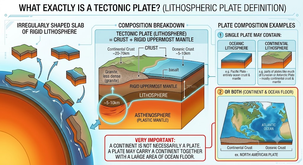
A tectonic plate, also called a lithospheric plate, is a very large, irregularly shaped slab of rigid lithosphere.
A single plate may contain:
Very Important: A continent is not necessarily a plate. A plate may carry a continent together with a large area of ocean floor.
3. Crust and Plate Are Not the Same Thing
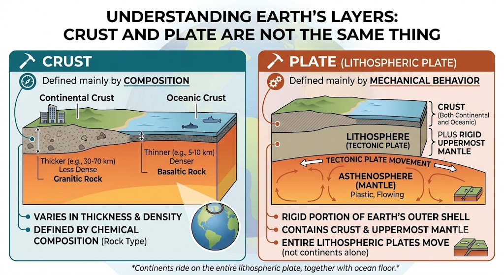
Crust
Defined mainly by composition.
Continental crust and oceanic crust differ in thickness, density and rock composition.
Plate
Defined mainly by mechanical behaviour.
It is a rigid portion of lithosphere containing crust plus uppermost mantle.
4. How Do Plates Behave?
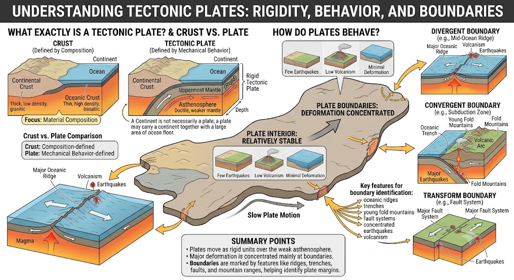
Plates behave as relatively rigid units and move slowly over the weaker mantle beneath them.
Most major deformation does not occur throughout the entire plate. It is concentrated mainly near plate boundaries.
Plate boundaries → deformation, faults, mountains, earthquakes and volcanism
This is why major oceanic ridges, trenches, young fold mountains and fault systems help identify the margins of tectonic plates.
5. Major Tectonic Plates
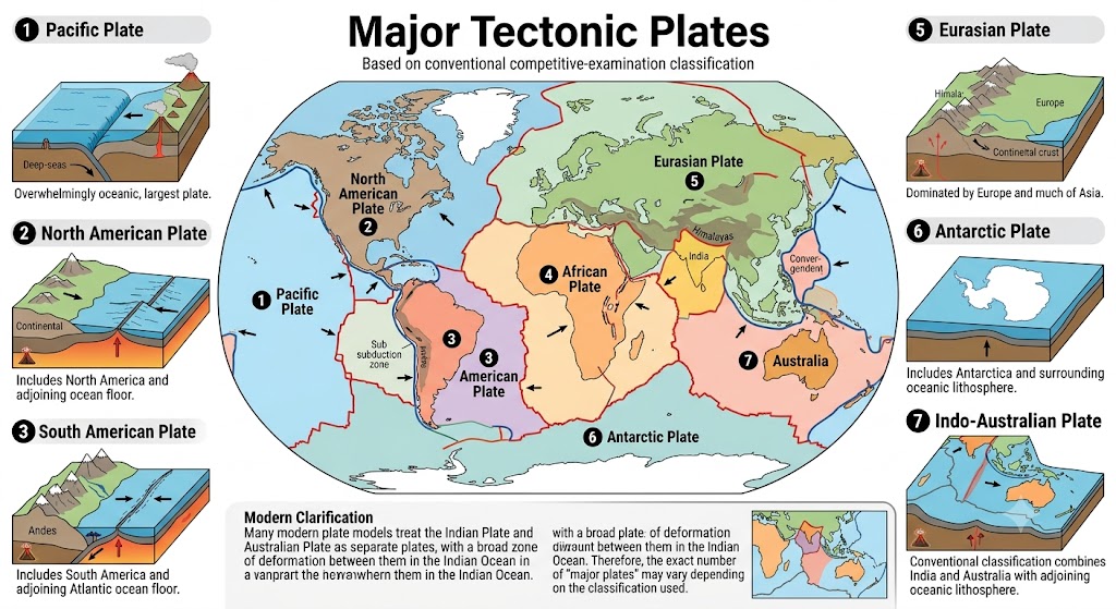
For conventional competitive-examination classification, the lithosphere is commonly divided into seven major plates.
1. Pacific Plate
Largest plate; overwhelmingly oceanic.
2. North American Plate
Includes North America and adjoining ocean floor.
3. South American Plate
Includes South America and adjoining Atlantic ocean floor.
4. African Plate
Includes most of Africa and large adjoining oceanic regions.
5. Eurasian Plate
Dominated by Europe and much of Asia.
6. Antarctic Plate
Includes Antarctica and surrounding oceanic lithosphere.
7. Indo-Australian Plate
Conventional classification combines India and Australia with adjoining oceanic lithosphere.
Modern clarification: Many modern plate models treat the Indian Plate and Australian Plate as separate plates, with a broad zone of deformation between them in the Indian Ocean. Therefore, the exact number of “major plates” may vary depending on the classification used.
6. Why Do We Call Some Plates Continental or Oceanic?
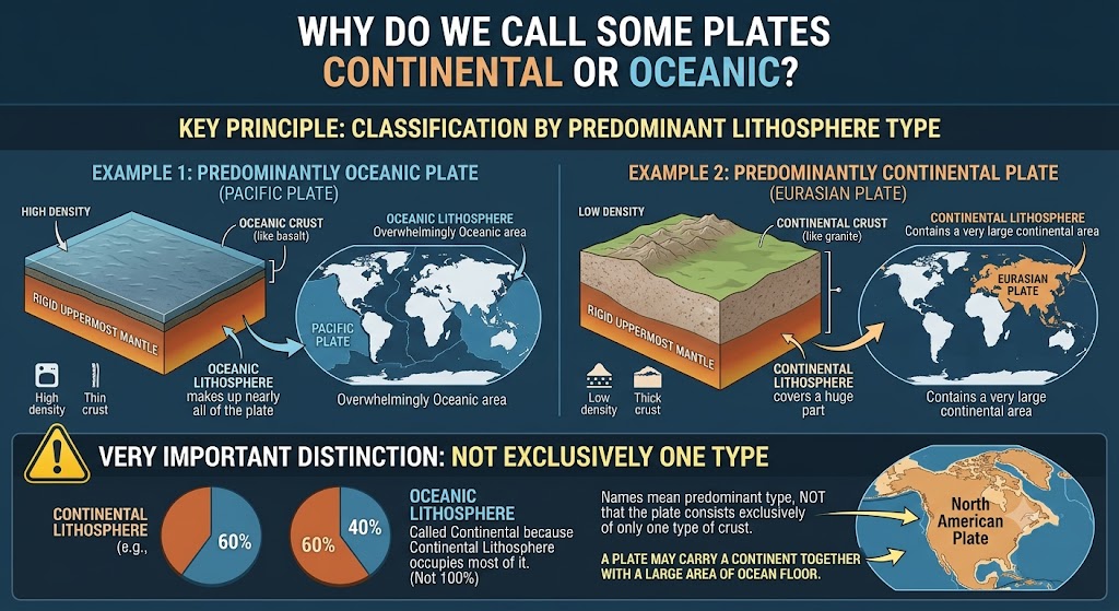
A plate is sometimes called continental or oceanic according to which type of lithosphere occupies most of it.
Pacific Plate
Mainly oceanic → commonly described as an oceanic plate.
Eurasian Plate
Contains a very large continental area → often described as a continental plate.
These names do not mean that the plate consists exclusively of only one type of crust.
7. Important Minor Plates
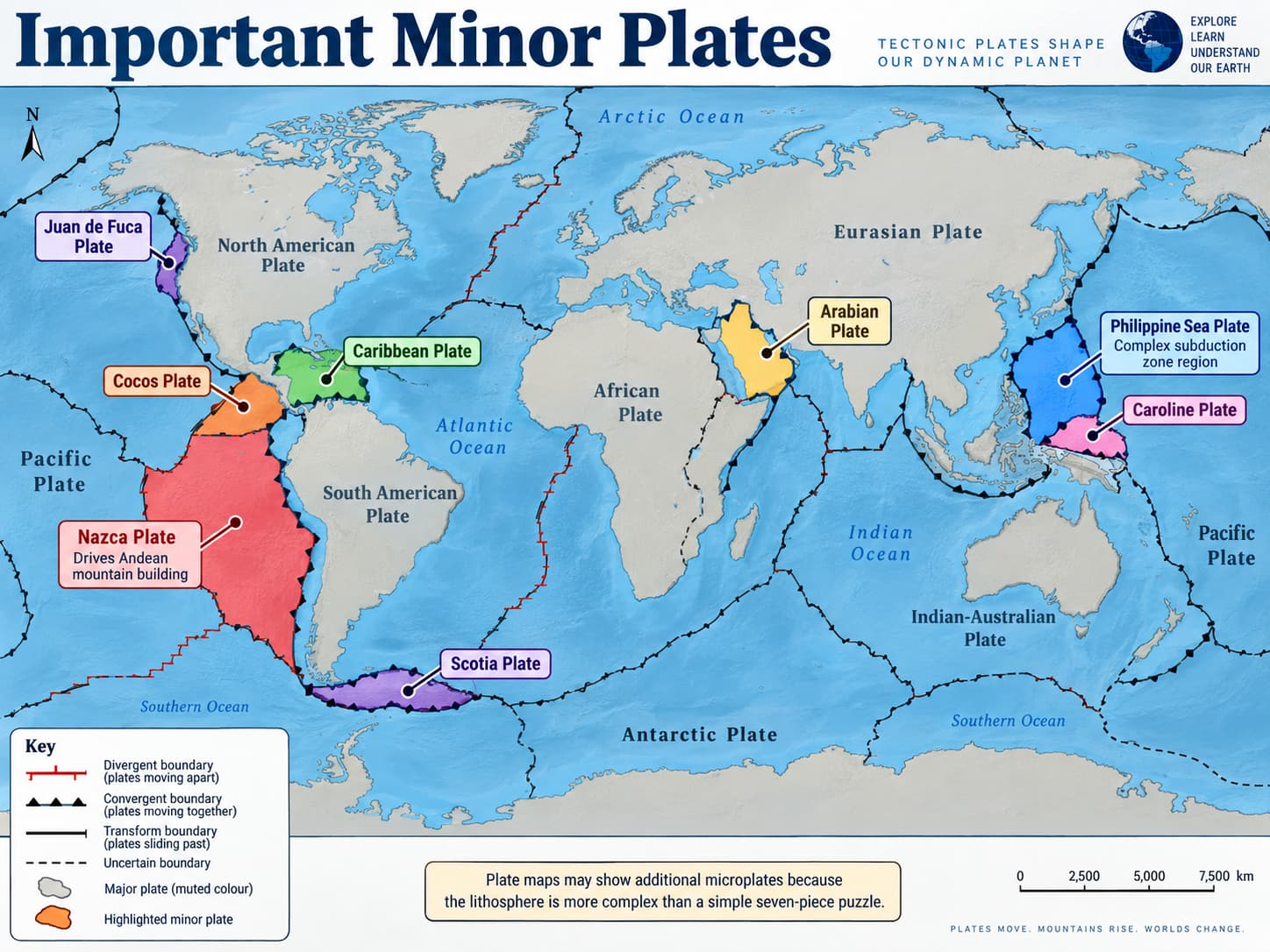
In addition to the major plates, several smaller plates and microplates are tectonically very important.
Plate maps may show additional microplates because the lithosphere is more complex than a simple seven-piece puzzle.
8. Plates Have Always Been Moving
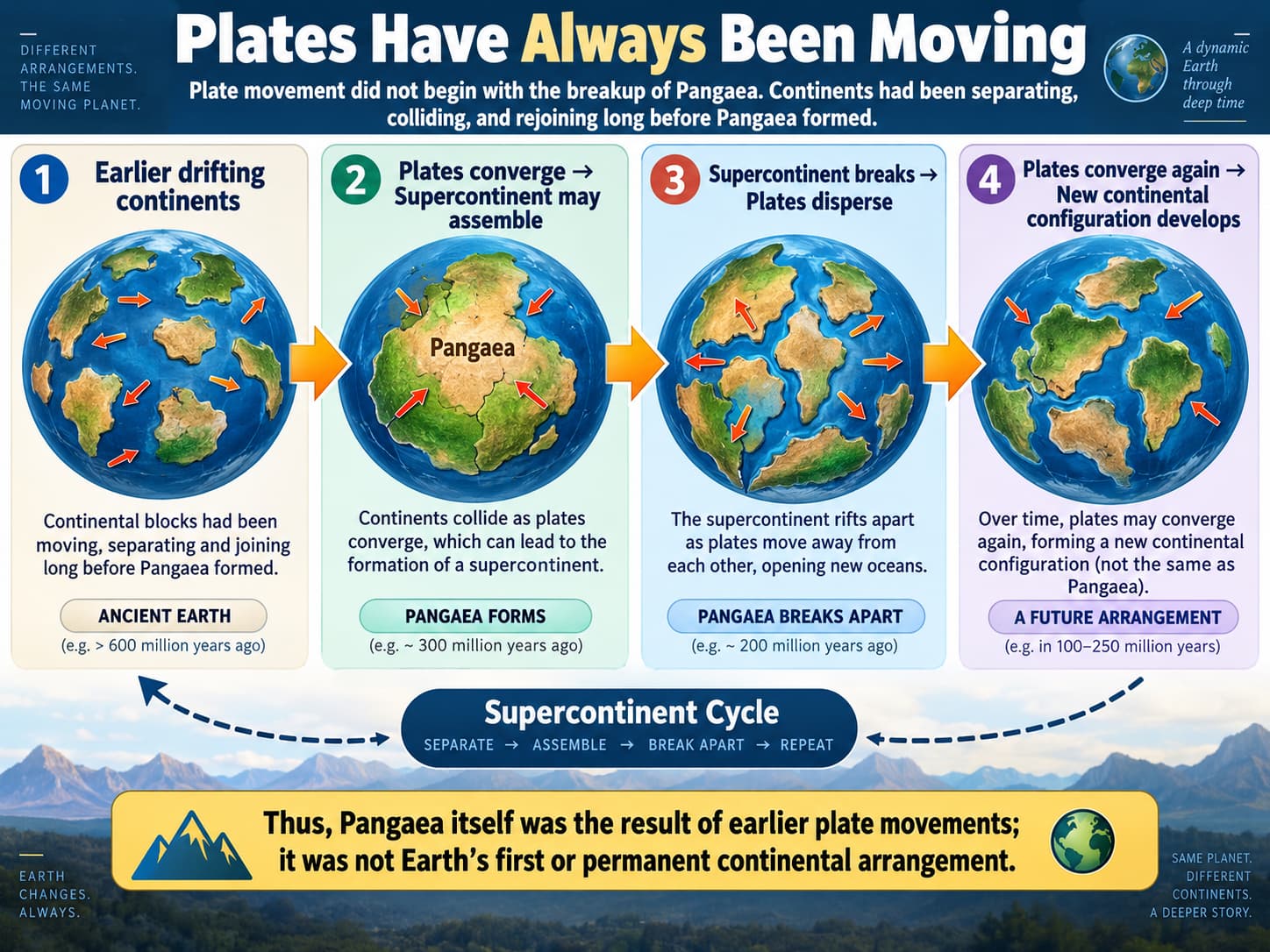
Plate movement did not begin with the breakup of Pangaea.
Continental blocks had been moving, separating and joining long before Pangaea formed.
Supercontinent breaks → Plates disperse
Plates converge again → New continental configuration develops
Thus, Pangaea itself was the result of earlier plate movements; it was not the Earth's first or permanent continental arrangement.
9. How Do We Reconstruct Past Plate Positions?
Scientists combine several types of evidence to reconstruct earlier plate positions:
paleomagnetism preserved in rocks,
magnetic stripes on the ocean floor,
ages of oceanic crust,
matching geological structures and fossils,
modern geodetic measurements.
An important Indian example is the use of palaeomagnetic evidence from rocks of the Nagpur region to help reconstruct the earlier position of Peninsular India.
India's complete journey from Gondwana to Eurasia will be studied separately so that it can be connected properly with Deccan volcanism and Himalayan orogeny.
10. How Fast Do Plates Move?
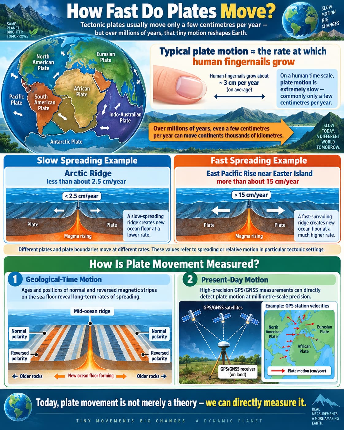
Plate movement is usually very slow on a human time scale—commonly only a few centimetres per year.
Over millions of years, however, even a few centimetres per year can move continents thousands of kilometres.
Slow Spreading Example
Arctic Ridge: textbook value of less than about 2.5 cm/year.
Fast Spreading Example
East Pacific Rise near Easter Island: textbook value of more than about 15 cm/year.
These values refer to spreading/relative movement in particular tectonic settings; different plates and boundaries move at different rates.
11. How Is Plate Movement Measured?
Geological-Time Motion
Ages and positions of normal and reversed magnetic stripes on the sea floor reveal long-term rates of spreading.
Present-Day Motion
High-precision GPS/GNSS measurements can directly detect plate motion at millimetre-scale precision.
12. Why Do Tectonic Plates Move?
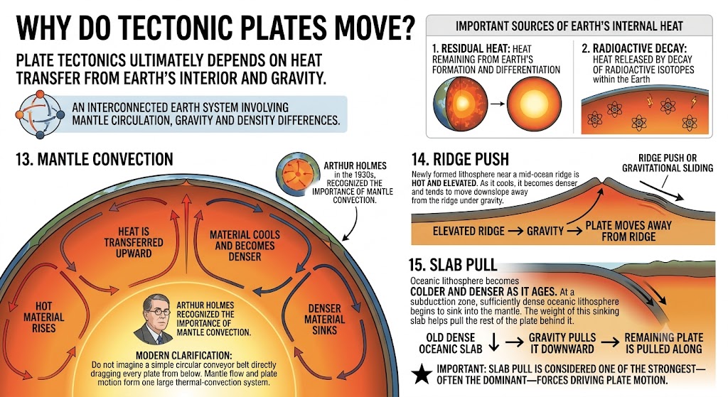
Plate tectonics ultimately depends on the transfer of heat from Earth's interior and on gravity.
Important sources of Earth's internal heat include:
Residual Heat
Heat remaining from Earth's formation and differentiation.
Radioactive Decay
Heat released by decay of radioactive isotopes within the Earth.
There is no single force acting alone. Plate motion results from a connected Earth system involving mantle circulation, gravity and the density differences between young and old lithosphere.
13. Mantle Convection
Hot mantle material can rise slowly, spread, cool and eventually sink again. This large-scale transfer of heat is called mantle convection.
↓
Heat is transferred upward
↓
Material cools and becomes denser
↓
Denser material sinks
Arthur Holmes recognised the importance of mantle convection in the 1930s, long before plate tectonics became widely accepted.
Modern clarification: Do not imagine a simple circular conveyor belt directly dragging every plate from below. Mantle flow and plate motion form one large thermal-convection system, while gravitational forces associated with ridges and sinking slabs are also extremely important.
14. Ridge Push
Newly formed lithosphere near a mid-ocean ridge is hot and elevated.
As it cools, it becomes denser and tends to move downslope away from the ridge under gravity.
This gravitational effect is commonly called ridge push or gravitational sliding.
15. Slab Pull
Oceanic lithosphere becomes colder and denser as it ages.
At a subduction zone, sufficiently dense oceanic lithosphere begins to sink into the mantle.
The weight of this sinking slab helps pull the rest of the plate behind it.
Gravity pulls it downward
↓
Remaining plate is pulled along
Important: In many modern geodynamic models, slab pull is considered one of the strongest—often the dominant—forces driving plate motion.
16. Driving Forces: Put Them Together
Heat + gravity + mantle circulation + density differences work together.
17. Hotspots: Volcanism Away from Plate Boundaries
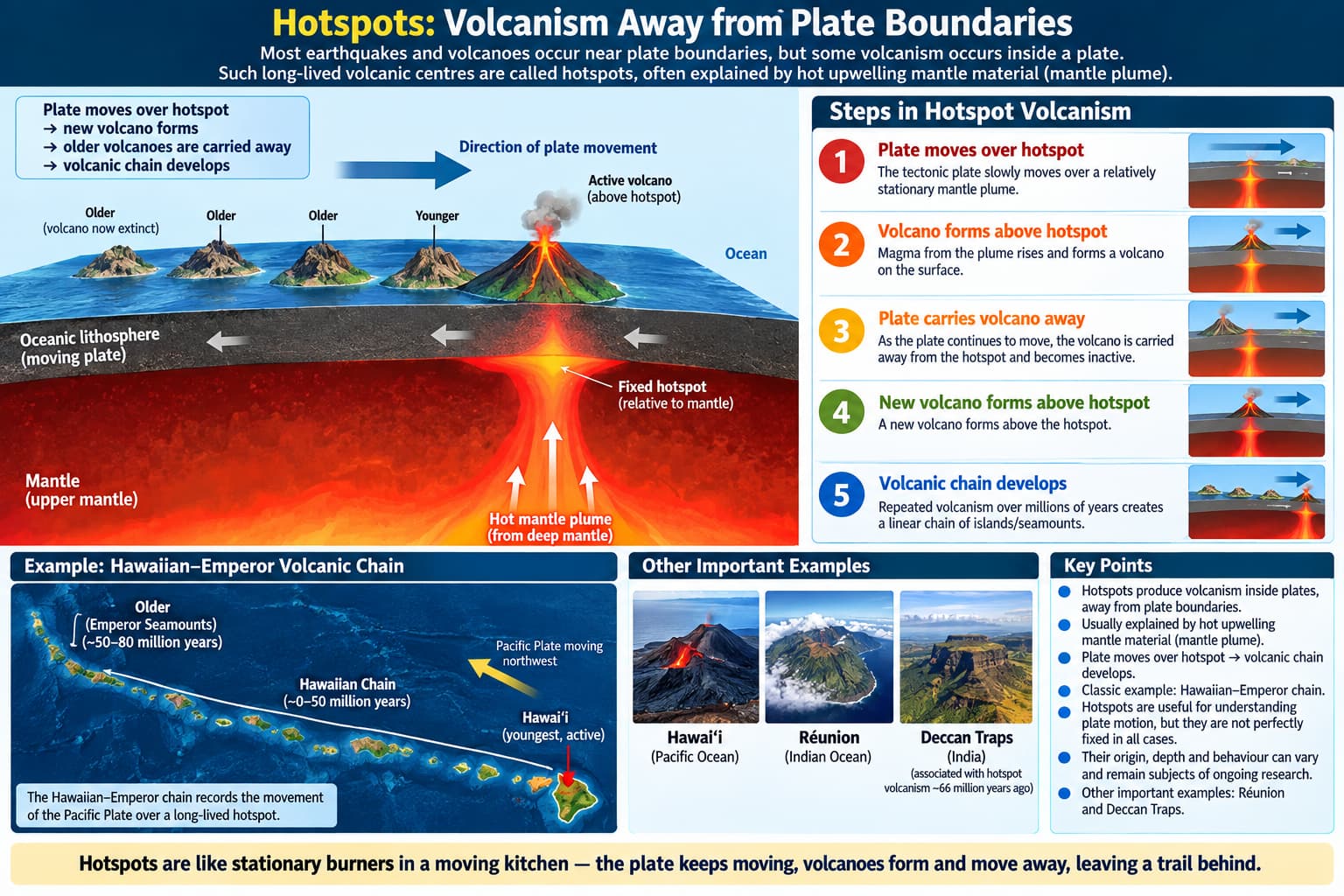
Most earthquakes and volcanoes occur near plate boundaries, but some volcanism occurs inside a plate.
Such long-lived volcanic centres are commonly called hotspots. Many are explained by unusually hot upwelling mantle material, often described as a mantle plume.
↓
Volcano forms above hotspot
↓
Plate carries volcano away
↓
New volcano forms above hotspot
↓
Volcanic chain develops
The classic example is the Hawaiian–Emperor volcanic chain.
Hotspots are useful for understanding plate motion, but they are not perfectly fixed in all cases. Their exact origin and depth can also vary and remain subjects of geodynamic research.
Hotspot/plume volcanism will become especially important later when we study Hawaii, Réunion and the Deccan Traps.
18. Plates Interact at Their Boundaries
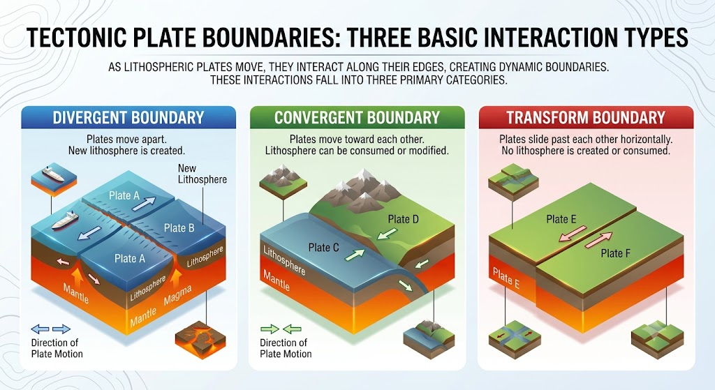
Once plates move, they must interact with neighbouring plates. There are three basic types of interaction:
Divergent
Plates move apart.
Convergent
Plates move toward each other.
Transform
Plates slide past each other.
Their detailed processes, sub-types and associated landforms will be studied in the next post, so they are not repeated here.
19. Why Plate Tectonics is So Important
Plate tectonics provides a single framework for understanding many apparently unrelated features of the Earth.
↓
Oceans Open and Close
↓
Continents Join and Separate
↓
Mountains, Trenches, Rifts and Island Arcs Form
↓
Earthquakes and Volcanoes Concentrate in Tectonic Belts
In the coming posts, we will use this theory to explain the actual present world map rather than treating mountains, islands and volcanoes as isolated facts.
20. Common Confusions to Avoid
Incorrect. A plate may contain both continental and oceanic lithosphere.
Incorrect. Entire lithospheric plates—including their oceanic portions—move.
Incorrect. The mantle is mainly solid but can deform and flow very slowly over geological time.
Oversimplified. Modern plate dynamics involve mantle circulation, slab pull, ridge push and other resisting or assisting forces.
Incorrect. Hotspot volcanism can also occur within plates, as in Hawaii.
Incorrect. Continental blocks had assembled and dispersed before Pangaea as well.
Quick Revision
Plate tectonics developed as a unified theory mainly during the 1960s.
A tectonic plate is a rigid slab of lithosphere.
Plate = crust + rigid uppermost mantle.
A single plate may contain both continental and oceanic lithosphere.
Conventional exam classification recognises seven major plates.
Important minor plates include Nazca, Cocos, Arabian, Philippine Sea and Caroline.
Caribbean, Scotia and Juan de Fuca are also important smaller plates.
Modern models often distinguish the Indian and Australian plates.
Plates have moved throughout geological history and will continue to move.
Pangaea itself formed by earlier convergence of continental masses.
Plate motion is generally measured in centimetres per year.
Long-term motion can be calculated using magnetic stripes; modern motion can be measured directly by GPS/GNSS.
Earth's internal heat comes mainly from residual heat and radioactive decay.
Major controls on plate motion include mantle convection, ridge push and slab pull.
Slab pull is generally considered one of the strongest plate-driving forces.
Hotspots explain important examples of intraplate volcanism.
Think Like UPSC
Consider the following statement: “The Eurasian Plate consists only of continental crust.”
Another common trap: “Mantle convection is the only force responsible for plate movement.”
प्लेट विवर्तनिकी सिद्धांत: स्थलमंडलीय प्लेटें और उनकी गति
महाद्वीपीय विस्थापन ने दिखाया कि महाद्वीपों की स्थिति बदलती रही है, जबकि समुद्र-तल प्रसार ने दिखाया कि समुद्र तल भी गतिशील है।
प्लेट विवर्तनिकी सिद्धांत ने इन खोजों को एक विचार में समाहित किया: पृथ्वी का कठोर स्थलमंडल गतिशील प्लेटों में विभाजित है।
1. महाद्वीपीय विस्थापन से प्लेट विवर्तनिकी तक
1960 के दशक तक कई खोजों को अलग-अलग समझाना संभव नहीं रह गया था:
महाद्वीपों की स्थितियाँ बदलती रही थीं,
मध्य-महासागरीय कटक पर नई महासागरीय भूपर्पटी बनती थी,
महासागरीय खाइयों पर पुराना महासागरीय स्थलमंडल नष्ट हो जाता था,
भूकंप और ज्वालामुखी मुख्यतः संकरे वैश्विक पट्टों में पाए जाते थे।
महाद्वीप, कहीं अधिक बड़ी गतिशील स्थलमंडलीय प्लेटों पर सवार होते हैं।
1960 के दशक में जे. टुज़ो विल्सन, डैन मैकेंज़ी, रॉबर्ट पार्कर और जेसन मॉर्गन जैसे वैज्ञानिकों के कार्य ने प्लेट विवर्तनिकी के आधुनिक सिद्धांत के विकास में सहायता की।
2. वास्तव में विवर्तनिक प्लेट क्या होती है?
एक विवर्तनिक प्लेट, जिसे स्थलमंडलीय प्लेटभी कहा जाता है, कठोर स्थलमंडल का बहुत बड़ा, अनियमित आकार का खंड होती है।
एक ही प्लेट में शामिल हो सकते हैं:
बहुत महत्वपूर्ण: महाद्वीप आवश्यक रूप से प्लेट नहीं होता। एक प्लेट किसी महाद्वीप के साथ-साथ समुद्र तल का एक बड़ा क्षेत्र भी वहन कर सकती है।
3. भूपर्पटी और प्लेट एक ही चीज़ नहीं हैं
भूपर्पटी
मुख्यतः संघटनके आधार पर परिभाषित होती है।
महाद्वीपीय और महासागरीय भूपर्पटी मोटाई, घनत्व और शैल-संघटन में भिन्न होती हैं।
प्लेट
मुख्यतः यांत्रिक व्यवहारके आधार पर परिभाषित होती है।
यह स्थलमंडल का कठोर भाग है, जिसमें भूपर्पटी और ऊपरीतम मैंटल शामिल होते हैं।
4. प्लेटें किस प्रकार व्यवहार करती हैं?
प्लेटें अपेक्षाकृत कठोर इकाइयों की तरह व्यवहार करती हैं और अपने नीचे स्थित अपेक्षाकृत दुर्बल मैंटल पर धीरे-धीरे गतिशील रहती हैं।
अधिकांश प्रमुख विकृति पूरी प्लेट में नहीं होती। यह मुख्यतः प्लेट सीमाओंके निकट केंद्रित रहती है।
प्लेट सीमाएँ → विकृति, भ्रंश, पर्वत, भूकंप और ज्वालामुखीयता
इसी कारण प्रमुख महासागरीय कटक, खाइयाँ, नवीन वलित पर्वत और भ्रंश तंत्र विवर्तनिक प्लेटों की सीमाओं की पहचान करने में सहायता करते हैं।
5. प्रमुख विवर्तनिक प्लेटें
प्रतियोगी परीक्षाओं में प्रचलित पारंपरिक वर्गीकरण के अनुसार स्थलमंडल को सामान्यतः सात प्रमुख प्लेटोंमें विभाजित किया जाता है।
1. प्रशांत प्लेट
सबसे बड़ी प्लेट; लगभग पूरी तरह महासागरीय।
2. उत्तर अमेरिकी प्लेट
इसमें उत्तर अमेरिका और उससे लगा समुद्र तल शामिल है।
3. दक्षिण अमेरिकी प्लेट
इसमें दक्षिण अमेरिका और उससे लगा अटलांटिक महासागरीय तल शामिल है।
4. अफ्रीकी प्लेट
इसमें अफ्रीका का अधिकांश भाग और उससे जुड़े विशाल महासागरीय क्षेत्र शामिल हैं।
5. यूरेशियन प्लेट
इसमें यूरोप और एशिया का बड़ा भाग प्रमुख है।
6. अंटार्कटिक प्लेट
इसमें अंटार्कटिका और उसके आसपास का महासागरीय स्थलमंडल शामिल है।
7. इंडो-ऑस्ट्रेलियाई प्लेट
पारंपरिक वर्गीकरण में भारत और ऑस्ट्रेलिया को उनसे जुड़े महासागरीय स्थलमंडल सहित एक ही प्लेट में रखा जाता है।
आधुनिक स्पष्टीकरण: कई आधुनिक प्लेट मॉडल भारतीय प्लेट और ऑस्ट्रेलियाई प्लेट को अलग-अलग प्लेटेंमानते हैं, जिनके बीच हिंद महासागर में विकृति का एक विस्तृत क्षेत्र है। इसलिए “प्रमुख प्लेटों” की सही संख्या प्रयुक्त वर्गीकरण के अनुसार भिन्न हो सकती है।
6. कुछ प्लेटों को महाद्वीपीय या महासागरीय क्यों कहा जाता है?
किसी प्लेट को कभी-कभी महाद्वीपीय या महासागरीय उसमें किस प्रकार का स्थलमंडल अधिक भाग घेरता है, इसके आधार पर कहा जाता है।
प्रशांत प्लेट
मुख्यतः महासागरीय → सामान्यतः इसे महासागरीय प्लेटकहा जाता है।
यूरेशियन प्लेट
इसमें बहुत बड़ा महाद्वीपीय क्षेत्र है → इसलिए इसे प्रायः महाद्वीपीय प्लेटकहा जाता है।
इन नामों का अर्थ यह नहीं है कि प्लेट केवल एक ही प्रकार की भूपर्पटी से बनी होती है।
7. महत्वपूर्ण लघु प्लेटें
प्रमुख प्लेटों के अतिरिक्त कई छोटी प्लेटें और सूक्ष्म-प्लेटें भी विवर्तनिकी की दृष्टि से बहुत महत्वपूर्ण हैं।
प्लेट मानचित्रों में अतिरिक्त सूक्ष्म-प्लेटें भी दिखाई जा सकती हैं, क्योंकि स्थलमंडल साधारण सात टुकड़ों वाली पहेली से कहीं अधिक जटिल है।
8. प्लेटें हमेशा से गतिशील रही हैं
प्लेटों की गति पैंजिया के विखंडन से शुरू नहीं हुई थी।
पैंजिया के बनने से बहुत पहले से ही महाद्वीपीय खंड गतिशील थे, अलग हो रहे थे और पुनः जुड़ रहे थे।
महाद्वीपीय महासमूह टूटता है → प्लेटें फैल जाती हैं
प्लेटें फिर अभिसरित होती हैं → नई महाद्वीपीय व्यवस्था विकसित होती है
इस प्रकार, पैंजिया स्वयं पहले के प्लेट संचलनों का परिणाम था; यह पृथ्वी की पहली या स्थायी महाद्वीपीय व्यवस्था नहीं थी।
9. हम अतीत की प्लेट स्थितियों का पुनर्निर्माण कैसे करते हैं?
वैज्ञानिक पुरानी प्लेट स्थितियों का पुनर्निर्माण करने के लिए कई प्रकार के प्रमाणों को मिलाकर देखते हैं:
शैलों में संरक्षित पुराचुंबकत्व,
समुद्र तल पर चुंबकीय पट्टियाँ,
महासागरीय भूपर्पटी की आयु,
मेल खाते भूवैज्ञानिक ढाँचे और जीवाश्म,
आधुनिक भू-मापन संबंधी माप।
भारत का एक महत्वपूर्ण उदाहरण है नागपुर क्षेत्र की शैलों से प्राप्त पुराचुंबकीय प्रमाणों का उपयोग, जिनसे प्रायद्वीपीय भारत की पुरानी स्थिति का पुनर्निर्माण करने में सहायता मिलती है।
गोंडवाना से यूरेशिया तक भारत की पूरी यात्रा को अलग से पढ़ा जाएगा, ताकि इसे दक्कन ज्वालामुखीयता और हिमालयी पर्वतनिर्माण से सही प्रकार से जोड़ा जा सके।
10. प्लेटें कितनी तेज़ी से चलती हैं?
मानव समय-मान पर प्लेटों की गति सामान्यतः बहुत धीमी होती है—अक्सर केवल कुछ सेंटीमीटर प्रति वर्ष।
लेकिन लाखों वर्षों में प्रति वर्ष कुछ सेंटीमीटर की गति भी महाद्वीपों को हजारों किलोमीटर दूर ले जा सकती है।
धीमे प्रसार का उदाहरण
आर्कटिक कटक: पाठ्यपुस्तक में दिया गया मान लगभग 2.5 सेमी/वर्ष से कम।
तेज़ प्रसार का उदाहरण
ईस्टर द्वीप के निकट ईस्ट पैसिफिक राइज़: पाठ्यपुस्तक में दिया गया मान लगभग 15 सेमी/वर्ष से अधिक।
ये मान विशेष विवर्तनिक परिस्थितियों में प्रसार/सापेक्ष गति से संबंधित हैं; अलग-अलग प्लेटें और सीमाएँ अलग-अलग दरों से चलती हैं।
11. प्लेटों की गति कैसे मापी जाती है?
भूवैज्ञानिक समय की गति
समुद्र तल पर सामान्य और उल्टी चुंबकीय पट्टियों की आयु और स्थिति से दीर्घकालीन प्रसार दरों का पता चलता है।
वर्तमान काल की गति
उच्च-सटीकता वाले GPS/GNSS मापन मिलीमीटर स्तर की सटीकता से प्लेटों की गति को सीधे दर्ज कर सकते हैं।
12. विवर्तनिक प्लेटें क्यों चलती हैं?
प्लेट विवर्तनिकी अंततः पृथ्वी के आंतरिक भाग की ऊष्मा के स्थानांतरण और गुरुत्वाकर्षणपर निर्भर करती है।
पृथ्वी की आंतरिक ऊष्मा के महत्वपूर्ण स्रोतों में शामिल हैं:
अवशिष्ट ऊष्मा
पृथ्वी के निर्माण और विभेदन से बची हुई ऊष्मा।
रेडियोधर्मी क्षय
पृथ्वी के भीतर रेडियोधर्मी समस्थानिकों के क्षय से निकलने वाली ऊष्मा।
कोई एक अकेला बल कार्य नहीं करता। प्लेटों की गति एक परस्पर जुड़ी पृथ्वी-प्रणाली का परिणाम है, जिसमें मैंटल परिसंचरण, गुरुत्वाकर्षण तथा युवा और पुरानी स्थलमंडलीय सामग्री के घनत्व में अंतर शामिल हैं।
13. मैंटल संवहन
गर्म मैंटल पदार्थ धीरे-धीरे ऊपर उठ सकता है, फैल सकता है, ठंडा हो सकता है और अंततः फिर नीचे धँस सकता है। ऊष्मा के इस बड़े पैमाने के स्थानांतरण को मैंटल संवहनकहा जाता है।
↓
ऊष्मा ऊपर की ओर स्थानांतरित होती है
↓
पदार्थ ठंडा होकर अधिक घना हो जाता है
↓
अधिक घना पदार्थ नीचे धँसता है
आर्थर होम्स ने 1930 के दशक में ही मैंटल संवहन के महत्व को पहचान लिया था, जबकि प्लेट विवर्तनिकी को व्यापक स्वीकृति बहुत बाद में मिली।
आधुनिक स्पष्टीकरण: इसे ऐसा साधारण गोलाकार कन्वेयर बेल्ट न समझें जो नीचे से हर प्लेट को सीधे खींचता हो। मैंटल प्रवाह और प्लेट गति मिलकर एक बड़े तापीय-संवहन तंत्र का हिस्सा बनते हैं, जबकि कटक और नीचे धँसती स्लैब से जुड़े गुरुत्वीय बल भी अत्यंत महत्वपूर्ण हैं।
14. रिज पुश
मध्य-महासागरीय कटक के पास नया बना स्थलमंडल गर्म और ऊँचाहोता है।
ठंडा होने पर यह अधिक घना हो जाता है और गुरुत्वाकर्षण के कारण कटक से दूर ढाल की दिशा में खिसकने लगता है।
इस गुरुत्वीय प्रभाव को सामान्यतः रिज पुश या गुरुत्वीय फिसलन कहा जाता है।
15. स्लैब पुल
महासागरीय स्थलमंडल आयु बढ़ने के साथ अधिक ठंडा और अधिक घनाहो जाता है।
अधोगमन क्षेत्र में पर्याप्त घना महासागरीय स्थलमंडल मैंटल के भीतर धँसना शुरू कर देता है।
इस धँसती स्लैब का भार शेष प्लेट को भी अपने पीछे खींचने में सहायता करता है।
गुरुत्वाकर्षण उसे नीचे खींचता है
↓
बाकी प्लेट भी साथ खिंचती है
महत्वपूर्ण: कई आधुनिक भू-गतिकीय मॉडलों में स्लैब पुल को प्लेट गति चलाने वाले सबसे शक्तिशाली—और अक्सर प्रमुख—बलों में से एक माना जाता है।
16. प्लेट गति के बल: इन्हें एक साथ समझें
ऊष्मा + गुरुत्वाकर्षण + मैंटल परिसंचरण + घनत्व-अंतर मिलकर कार्य करते हैं।
17. हॉटस्पॉट: प्लेट सीमाओं से दूर ज्वालामुखीयता
अधिकांश भूकंप और ज्वालामुखी प्लेट सीमाओं के पास होते हैं, लेकिन कुछ ज्वालामुखीयता प्लेट के भीतरभी होती है।
ऐसे लंबे समय तक सक्रिय रहने वाले ज्वालामुखीय केंद्रों को सामान्यतः हॉटस्पॉटकहा जाता है। इनमें से कई को असामान्य रूप से गर्म ऊपर उठते मैंटल पदार्थ से समझाया जाता है, जिसे प्रायः मैंटल प्लूमकहा जाता है।
↓
हॉटस्पॉट के ऊपर ज्वालामुखी बनता है
↓
प्लेट ज्वालामुखी को दूर ले जाती है
↓
हॉटस्पॉट के ऊपर नया ज्वालामुखी बनता है
↓
ज्वालामुखीय श्रृंखला विकसित होती है
इसका प्रसिद्ध उदाहरण है हवाईयन–एम्परर ज्वालामुखीय श्रृंखला।
हॉटस्पॉट प्लेट गति को समझने में उपयोगी हैं, लेकिन सभी मामलों में वे पूरी तरह स्थिर नहीं होते। उनकी सही उत्पत्ति और गहराई भी अलग-अलग हो सकती है और ये अब भी भू-गतिकीय शोध के विषय हैं।
हॉटस्पॉट/प्लूम ज्वालामुखीयता आगे विशेष रूप से महत्वपूर्ण होगी, जब हम हवाई, रीयूनियन और दक्कन ट्रैप्सका अध्ययन करेंगे।
18. प्लेटें अपनी सीमाओं पर परस्पर क्रिया करती हैं
जब प्लेटें चलती हैं, तो उन्हें पड़ोसी प्लेटों के साथ परस्पर क्रिया करनी ही होती है। इस परस्पर क्रिया के तीन मूल प्रकार हैं:
अपसारी
प्लेटें एक-दूसरे से दूर जाती हैं।
अभिसारी
प्लेटें एक-दूसरे की ओर बढ़ती हैं।
रूपांतर
प्लेटें एक-दूसरे के पास से खिसकती हुई गुजरती हैं।
इनकी विस्तृत प्रक्रियाएँ, उप-प्रकार और संबंधित स्थलरूप अगले पोस्ट में पढ़े जाएंगे, इसलिए यहाँ उन्हें दोहराया नहीं गया है।
19. प्लेट विवर्तनिकी इतनी महत्वपूर्ण क्यों है?
प्लेट विवर्तनिकी पृथ्वी की अनेक ऐसी विशेषताओं को समझने के लिए एक एकीकृत ढाँचा प्रदान करती है जो देखने में एक-दूसरे से असंबंधित लगती हैं।
↓
महासागर खुलते और बंद होते हैं
↓
महाद्वीप जुड़ते और अलग होते हैं
↓
पर्वत, खाइयाँ, रिफ्ट और द्वीपीय चाप बनते हैं
↓
भूकंप और ज्वालामुखी विवर्तनिक पट्टों में केंद्रित होते हैं
आने वाले पोस्टों में हम इस सिद्धांत का उपयोग वर्तमान वास्तविक विश्व मानचित्र को समझाने के लिए करेंगे, न कि पर्वतों, द्वीपों और ज्वालामुखियों को अलग-अलग तथ्य मानकर।
20. सामान्य भ्रम जिनसे बचना चाहिए
गलत। एक प्लेट में महाद्वीपीय और महासागरीय दोनों प्रकार का स्थलमंडल हो सकता है।
गलत। पूरी स्थलमंडलीय प्लेटें—उनके महासागरीय भागों सहित—गतिशील होती हैं।
गलत। मैंटल मुख्यतः ठोस है, लेकिन भूवैज्ञानिक समय में यह बहुत धीरे-धीरे विकृत होकर प्रवाहित हो सकता है।
यह अत्यधिक सरलीकरण है। आधुनिक प्लेट गतिकी में मैंटल परिसंचरण, स्लैब पुल, रिज पुश तथा अन्य सहायक या प्रतिरोधी बल शामिल होते हैं।
गलत। हवाई की तरह हॉटस्पॉट ज्वालामुखीयता प्लेटों के भीतर भी हो सकती है।
गलत। पैंजिया से पहले भी महाद्वीपीय खंड जुड़ते और अलग होते रहे थे।
त्वरित पुनरावृत्ति
प्लेट विवर्तनिकी मुख्यतः 1960 के दशकमें एक एकीकृत सिद्धांत के रूप में विकसित हुई।
विवर्तनिक प्लेट स्थलमंडलका एक कठोर खंड होती है।
प्लेट = भूपर्पटी + कठोर ऊपरीतम मैंटल।
एक ही प्लेट में महाद्वीपीय और महासागरीय दोनों प्रकार का स्थलमंडल हो सकता है।
पारंपरिक परीक्षा-वर्गीकरण में सात प्रमुख प्लेटोंको मान्यता दी जाती है।
महत्वपूर्ण लघु प्लेटों में नाज़्का, कोकोस, अरब, फिलिपीन सागर और कैरोलीनशामिल हैं।
कैरेबियन, स्कोटिया और जुआन डी फूका भी महत्वपूर्ण छोटी प्लेटें हैं।
आधुनिक मॉडल अक्सर भारतीय और ऑस्ट्रेलियाई प्लेटोंको अलग-अलग मानते हैं।
प्लेटें पूरे भूवैज्ञानिक इतिहास में चलती रही हैं और आगे भी चलती रहेंगी।
पैंजिया स्वयं पहले के महाद्वीपीय पिंडों के अभिसरण से बना था।
प्लेट गति को सामान्यतः सेंटीमीटर प्रति वर्षमें मापा जाता है।
दीर्घकालीन गति की गणना चुंबकीय पट्टियोंसे की जा सकती है; आधुनिक गति को सीधे GPS/GNSSसे मापा जा सकता है।
पृथ्वी की आंतरिक ऊष्मा मुख्यतः अवशिष्ट ऊष्मा और रेडियोधर्मी क्षयसे आती है।
प्लेट गति को नियंत्रित करने वाले प्रमुख कारकों में मैंटल संवहन, रिज पुश और स्लैब पुलशामिल हैं।
स्लैब पुल को सामान्यतः प्लेट गति चलाने वाले सबसे शक्तिशाली बलों में से एक माना जाता है।
हॉटस्पॉट अंतःप्लेट ज्वालामुखीयताके महत्वपूर्ण उदाहरणों को समझाते हैं।
UPSC की तरह सोचें
निम्नलिखित कथन पर विचार कीजिए: “यूरेशियन प्लेट केवल महाद्वीपीय भूपर्पटी से बनी है।”
एक और सामान्य भ्रम: “प्लेटों की गति के लिए केवल मैंटल संवहन ही जिम्मेदार है।”